
 Explore Worlds
 Find Life
 Defend Earth


The Martian Craters Asimov and Danielson

Written by
Ken Edgett
Senior Research Scientist, Malin Space Science Systems
May 27, 2009
id: 00001965 pubdate: 2009-05-27 09:41:45
My two favorite craters were recently given official names by the International Astronomical Union (IAU). One was named for the author, Isaac Asimov (1920 - 1992), the other for G. Edward Danielson, Jr. (1939?2005), the instrument manager and co-investigator for the Mars Orbiter Camera (MOC) which revolutionized our views of Mars when it operated on MGS between 1997 and 2006.
Oh? ok--before I go on--Yes, it is true, all of my guest blog entries for The Planetary Society this week will be about Mars. Recognize that I'm quite interested in the rest of the Solar System, but what's on my mind this week--a year after the Phoenix landing and with my own (billable to contracts) work focused right now on MRO and MSL--is Mars. Oh--and NASA announced this morning the name for the Mars Science Laboratory (MSL) rover: Curiosity (see http://www.nasa.gov/mission_pages/msl/msl-20090527.html).
So, back to my favorite craters:
Asimov Crater was named this month (on 4 May) by the IAU. It has a diameter of about 84 kilometers (about 52 miles) and is located in Noachis Terra at 47.0° S, 355.1° W (or, 46.7° S, 4.9° E, if you prefer the coordinate system that all the cool kids are using today?but which is not the same as the coordinate system that was in use for the past few centuries). The crater, Danielson, was named on 12 February 2009. It's diameter is about 67 kilometers (about 42 miles) and it is located in western Arabia Terra at 8.0° N, 7.0° W (or 7.8° N, 352.9° E). Danielson is about 580 kilometers (about 360 miles) north-northwest of where the Mars Exploration Rover (MER), Opportunity, is currently operating.
NASA / JPL / MSSS
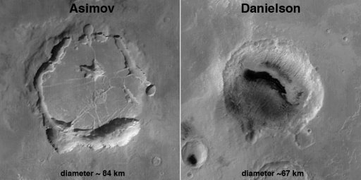
Asimov and Danielson Craters
Asimov Crater is located in Noachis Terra at 47.0° S, 355.1° W; Danielson is in western Arabia Terra at 8.0° N, 7.0° W. Both craters were named by the IAU this year. Note that Asimov is largely filled with material; large pits mark the interface between the ancient crater walls and the material that filled the crater. Although not obvious at the scale of the images presented here, the darkest materials in Danielson Crater are windblown sand dunes. The Asimov picture is from Mars Global Surveyor (MGS) Mars Orbiter Camera (MOC) red wide angle camera image M01-01232; the Danielson picture is also from the MOC red wide angle camera, image M01-00847. These pictures were taken during the MOC Geodesy Campaign ten years ago in May 1999. The images were map-projected by personnel at Malin Space Science Systems.For a crater on Mars to be named after a person, it must have a diameter greater than or equal to 60 kilometers (about 37 miles). The IAU rule for naming craters of diameters 60 km and larger on Mars are that they are to be named for persons deceased at least 3 years who contributed to the study or Mars or writers who contributed "to the lore of Mars" (IAU planetary nomenclature rules can be accessed here: http://planetarynames.wr.usgs.gov/). To approve naming a feature on Mars, the proposer(s) must show evidence that the feature needs a name--for example, if a scientific paper has been published in which the nameless feature is discussed at length, then a good case can be made to name that feature. (Frankly, I fear that the number of craters in the greater than or equal to 60 km size range that don't already have names is dwindling fast. Will the IAU have to lower the diameter range to 50, 40, or 30 kilometers to accommodate desires to name craters for people in the future?)
So, why are Asimov and Danielson my favorites?
Let's start with Asimov, named for the author of the 1952 short story, "The Martian Way," among others. Until it was given a name a few weeks ago, my colleague/employer, Mike Malin, and I referred to it as the "Noachis Pit Crater". We talked about it all the time, at least once a month, for the past decade--because it fascinates us. Asimov Crater has been almost completely filled with stuff--layers of who-knows-what--rocks, sand, and dust. Deep pits have developed at the interface between the buried crater wall and the material that filled Asimov. How this happened, I do no not know. It is one of the myriad and profound mysteries of Mars, as are all of the large craters that have been filled and buried, all over the planet. What I do know is that these pit walls show some spectacular things. Two of my favorite features on the entire planet are found in and on the walls of these deep pits.
The first really cool thing in Asimov Crater was initially seen at high resolution by the Mars Global Surveyor (MGS) Mars Orbiter Camera (MOC) on 2 January 2000. The picture (below) shows a sequence of layers at and near the top of the wall of one of the deep pits, near the crater's northwest rim. I use this picture all the time to illustrate an important finding of the MOC investigation--the bedrock of Mars is generally layered, and the layers exhibit different resistances to erosion. Regardless of how the erosion took place (in most cases we don't know all of the processes that expose and erode rock on Mars), some layers are tough enough to resist weathering and erosion better than other others. Those most resistant to erosion protrude, those that are less resistant to erosion are recessed. In this particular case, one layer (or group of layers) has recessed so far under overhanging, more-resistant rock layers that it cannot be seen. Essentially, there is a tremendous overhang here, like one might find at prehistoric rock shelters (sometimes with cliff dwellings within) on Earth. Indeed, the space beneath this overhang is great enough that you could stand upright and walk some distance inside!
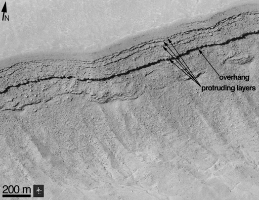
Credit: NASA / JPL / MSSS
Layer Resistance To Erosion and An Overhang in Asimov Crater
This MGS MOC image shows layers exposed on the upper walls of one of the deep pits of Asimov Crater. The smooth area at the top of the image is outside the depression and the terrain slopes toward the lower right. Some layers on the upper slope protrude, indicating that they are more resistant to erosion than the rest of the layers exposed at this location. Other layers are recessed?one of them is recessed so far that it cannot be seen because of the shadow cast by the overhang (formed of a protruding, erosion-resistant layer) above it. That overhang is large enough that a person could walk under it. The protruding layers consist of rock hard enough that, as it breaks down, it forms boulders that in some places have tumbled down the slope. The airplane next to the scale bar is shown just for fun. I don't recall what type of passenger jet it is, but I used to show this airplane for scale when describing this layer outcrop in public talks back in the 2000?2002 timeframe. This is a sub-frame of MOC image M11-00268, located near 47.1° S, 355.9° W.The difference in layer resistance to erosion tells us that the composition of these materials is not uniform. The material filling Asimov Crater was built up over some extended period of unknown duration, and the stuff that filled the crater consisted of sediments?and perhaps ash falls or even lava flows?of physical properties that, with each successive layer (or group of layers), changed over time. The materials may also have had different responses to groundwater percolating through the rock, resulting in layers having different resistances to erosion because of differences in how sediment or ash grains were cemented together. An equally interesting, though mysterious, issue is that of the very large boulders seen in some of these layers. Are these actually boulders? Were the boulders part of the sediment deposited in Asimov Crater, or are they the products of the more recent weathering and erosion of the layered rocks exposed in the pit wall? No one knows (yet).
My other favorite place in Asimov Crater (and, honestly, I've got more than two), is shown in the MGS MOC image below. This area was also imaged recently (March 2009)--at the request of the MRO CTX team--by the Mars Reconnaissance Orbiter (MRO) HiRISE at a higher spatial resolution and better signal-to-noise ratio (ahhhhhh, the differences between space camera technologies at the cutting edge of 1987 (MOC) and 2002 (HiRISE)!) in image ESP_012411_1320. This area shows a portion of one of the many networked channel/gully systems that exist on the walls of the deep pits of Asimov (hmmm--"The Deep Pits of Asimov"--that might make a cool short story title). In this case, a channel descends down a slope and appears to have diverted around boulders and split and re-joined several times. Such behavior is difficult to explain if the channel was not carved by a fluid that has the physical properties of liquid water (i.e., one could speculate that it was tomato juice, but tomato juice is mostly water). Whether this and other gullies in Asimov were caused by running water is not known, but I find the Asimov gullies to be particularly compelling.
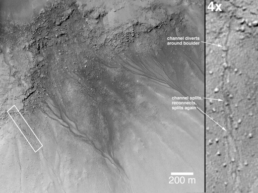
NASA / JPL / MSSS
Cascading Channel in Asimov
Some of the coolest martian mid-latitude gullies occur on the walls of the deep pits of Asimov. This location, imaged by MGS MOC on 5 February 2000, is my favorite. On the left is a portion of MOC image M12-00595, located near 47.8° S, 354.8° W. The terrain slopes from the upper left (northwest) toward the lower right (southeast). Several groups of stream channels coalesce downslope to form larger channels. What was the source of fluid that carved these channels? Groundwater? The fluid properties of the material are nicely illustrated by the "cascading gully channel" in the area covered by the white box. On the right is a 4x blow-up of the channel in the white box. Here, the channel-forming fluid ran down the slope (toward the bottom of the 4x sub-frame)--as it did so, it intersected and diverted around boulders, and it split and reconnected several times. While I've been using this image for nearly a decade to tell people about channels and gullies on Mars, there is now a brand new image, taken by the MRO HiRISE, which you can examine yourself: ESP_012411_1320.Now, to Danielson Crater. This one is important for understanding Mars and the concept that the upper crust of Mars contains many filled and buried impact craters of sizes ranging from meters to over a hundred kilometers. In some places, formerly filled and buried craters--and fluvial (stream) channels and valleys, for that matter--have been returned to the surface by tectonic and erosive forces. Danielson was certainly filled?or nearly so?and may well have also been completely buried.
MGS MOC images revealed that the interior of Danielson has hundreds of layers (or packages of layers too fine to be resolved by MOC or HiRISE) of repeated thickness and erosional expression. Unlike the layers in the deep pits of Asimov, the layers of rock that once filled (and, now, partially fill) Danielson are composed of a more uniform material?one layer erodes like the others, none is particularly more resistant to erosion than the others above it or below it. The anaglyph picture below shows some of the layers in Danielson as they appear to the MRO Context Camera (CTX) in stereo (3-d glasses with red left eye and blue right required).
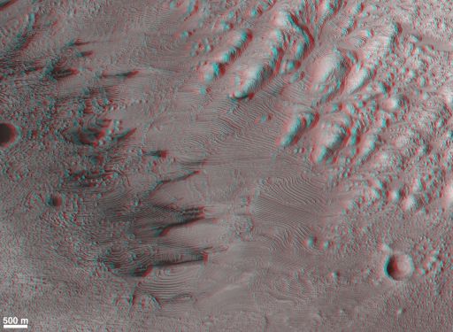
NASA / JPL / MSSS
Layered Rocks in Danielson Crater
This stereo anaglyph (red left eye, blue right eye) composed of MRO Context Camera (CTX) images shows some of the hundreds of layers of repeated thickness and erosional expression that occur in Danielson Crater. The layers toward the upper right of the figure dip steeply toward the lower left because they were deposited over the lower slopes of the crater wall. This is a composite of CTX images P04_002733_1881_XI_08N006W and P05_002878_1882_XI_08N006W, acquired in February and March 2007, respectively. North is up. The map-projection and anaglyph production were done by MRO CTX staff at Malin Space Science Systems.The layers in Danielson are nearly flat-lying out at the center of the crater, but the layers that overlie the lower crater walls are dipping toward the basin interior, in conformity with the crater wall slopes. The entire crater might have once been completely filled with this layered material. Indeed, the region in which Danielson occurs has hundreds of meters of nearly flat-lying, layered rock--including the bedrock being explored by the Mars Exploration Rover, Opportunity, on nearby Meridiani Planum. Given the topography of the region (see figure below), the nearly flat-lying nature of the bedrock, and the presence of a pedestal crater beneath which there are layers of flat-lying rock that stand about 700 meters (about 2300 feet) above the rim of Danielson Crater, it is possible that Danielson was once completely buried, as nearby (and similar-sized) Vernal Crater is still partly buried today.
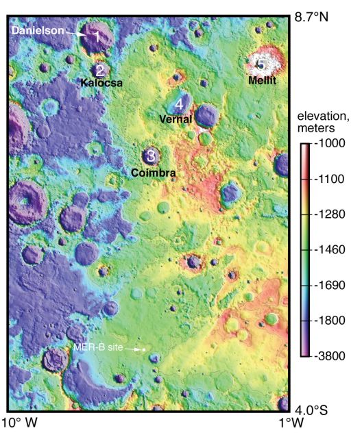
NASA / JPL / MSSS
Danielson Crater Might Have Been Buried
Danielson Crater (#1, above) may have once been buried beneath 600 - 700 meters (roughly 2000 - 2300 feet) of layered rock. This figure is a topographic map constructed at Malin Space Science Systems from Mars Global Surveyor (MGS) Mars Orbiter Laser Altimeter (MOLA) observations acquired in 1999?2001. Near the bottom center is the "MER-B site," the landing site of the rover, Opportunity. Five craters are numbered 1?5 and labeled according to names given to them by the IAU in 2008 and 2009. The bedrock in this region is nearly flat-lying, thus the topography gives some clues as to what layers of bedrock are higher than others. It turns out that the rocks being examined by Opportunity are roughly 600 meters above the rim of Danielson. If those rocks used to extend all the way to Danielson, then the crater was buried. However, the rover site is pretty far away--how can we know that those rocks were once more extensive? It turns out that Mellit Crater (#5) is the key. The ejecta blanket of Mellit helped keep several hundred meters of layered rock beneath it from being eroded away. Today, Mellit seems to sit atop a pedestal. The rocks preserved beneath Mellit's ejecta are at about the same elevation as the rocks at the MER-B site. And Mellit Crater was formed by a random impact, meaning that the rock into which Mellit formed was once much more extensive across the region. Indeed, to the immediate left (west) of Mellit is an arc which is a portion of the rim of a crater that is still mostly buried beneath the rock that comprises the pedestal beneath Mellit's ejecta blanket.No one knows for sure what sort of depositional setting is recorded in the layered rocks in Danielson Crater. There are only two basic types of environment that it could have been: subaerial or subaqueous. Subaerial means "beneath air" and subaqueous means "beneath water". In other words, sediment deposited on dry land after transport by wind, or sediment deposited in water (or similar liquid), after transport by water (or similar liquid), wind, or both. If the setting was subaqueous, then Danielson Crater hosted a lake or?yikes!?was at the bottom of a sea.
Both Asimov and Danielson craters present some intriguing mysteries. What are the layered materials, how were they deposited, and in what environments were they deposited? Are some of the layers made up of ejecta from other craters? Is there Hellas or Argyre ejecta in the layers filling Asimov, and would that explain the layers that seem to be bouldery? In each crater, the environments recorded by the layered materials might have changed over time, with the oldest rocks at the bottom of the layered stack, and the youngest at the top. How were the layered materials altered after they were emplaced? Was groundwater involved, as was the case for the rocks examined by the MER-B rover, Opportunity? How were the rocks later returned to the surface of Mars? If Danielson was once buried, how did it get exhumed? How did the rock break apart and get removed from the crater? And just what the heck formed the deep pits of Asimov? Further, what formed the gullies in Asimov, and what would we find if we could walk into the cave formed by that huge overhang on the northwest wall?
It gives me chills when I think about it.
Protect Our Shared Future
You help us defend humanity and prevent asteroid impacts. Donate now to become a Planetary Defender!
Donate