
 Explore Worlds
 Find Life
 Defend Earth


AGU: Titan: Volcanically active world, or "Callisto with weather?"
Written by
Emily Lakdawalla
December 17, 2008
There was much more to Monday's Titan sessions at the American Geophysical Union meeting than the one surprising fact I posted about on Monday. I was struck by something that one of the Cassini spectroscopists, Tom McCord, said as he opened his talk: that even though Cassini has now completed its primary mission at the Saturn system, which included dozens of Titan flybys over four years, and has now gone on to an extended mission, "the science is the least mature of any [extended] mission I've ever worked on." It's not for lack of effort; it's just that Titan is fiendishly difficult to study. Here's the main reason:

NASA / JPL / SSI
Titan's atmosphere
On June 29, 2007, Cassini sailed into Titan's shadow and captured this dramatic view of the moon as it occulted the Sun. Sunlight scatters through the moon's tall atmosphere all around the globe -- a picture of "all the sunsets and sunrises taking place on Titan at once." Titan's north polar "hood" is visible at the upper left.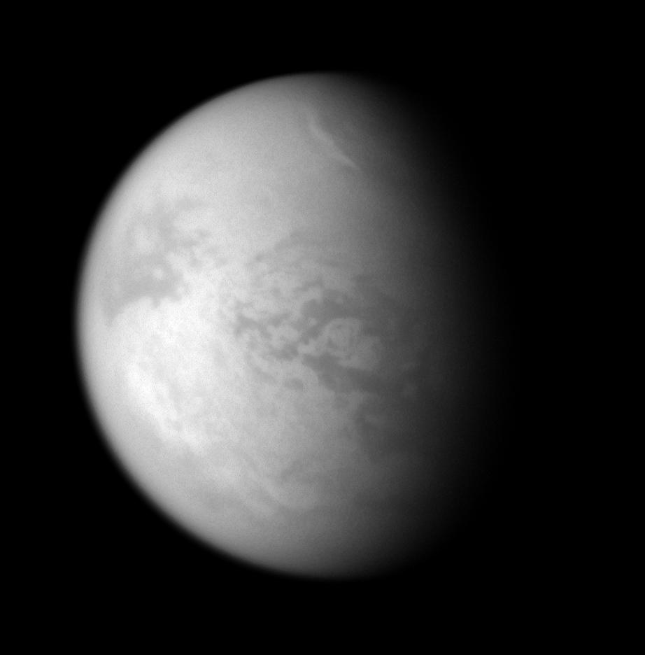
NASA / JPL / SSI
Polar cloud on Titan
Cassini's cameras captured this view of Titan using a filter sensitive to a wavelength of light at which methane gas is transparent. That allows Cassini to see right to Titan's surface in most locations. However, near the north pole, there is a bright streak, a cloud that is most likely made of droplets of methane liquid. Cassini took the photo on January 20, 2008.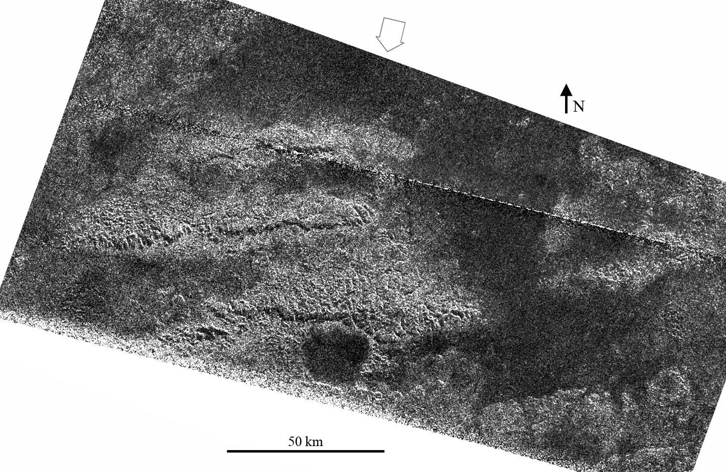
NASA / JPL
Parallel ridges on Titan
Cassini's radar instrument captured this view of three parallel ridges on Titan during its May 12, 2008 flyby. The ridges show up within the equatorial rough region called Xanadu.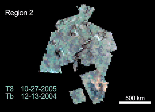
NASA / JPL / UA
Changes on Titan
Three images taken by Cassini's Visual and Infrared Mapping Spectrometer of the same region of Titan show the spectral properties of the surface changing with time. The images were taken during flybys in October 2005, January 2006, and March 2006. The VIMS team interprets these changes to result from cryovolcanism on Titan, but other Titan scientists are not convinced.- What is the source of the methane for the hydrologic [that is, methanologic] cycle?
Titan has methane in its atmosphere, which should quickly be destroyed by solar radiation. So it's got to be replenished somehow. Is cryovolcanism responsible? Or something else? - Where has all the ethane gone?
Where there's methane, there should be ethane, but there isn't much in the atmosphere or on the surface, though it's been detected in one southern lake. - Did a significant "dry" period precede the current epoch?
In other words, are we seeing Titan at an unusually "wet" period in its climatic evolution, or is its current state "normal"? - What imposes the N-S asymmetry in the lakes?
I'll talk more about this below -- there are more lakes in the north than in the south, and it's not clear why. - How deep/extensive are the lakes and what do they hold?
- Is there active cryovolcanism or geysering on Titan? Has there been significant cryovolcanism in the past?
This is an area of particularly active debate. - What is the origin of Titan's mountains?
Are they a sign of internal geologic activity, or not? - Is the primary degradation process fluvial erosion or burial?
Titan's surface has few obvious craters, so something must be erasing them. Are they being eroded or buried?
NASA / JPL
Radar images of areas on Titan observed to change in VIMS images
"Region 1" and "Region 2" are two locations on Titan at which the Visual and Infrared Mapping Spectrometer team has observed changes in the properties of Titan's surface with time. Both are within the Xanadu bright region. Region 1 is just north of the feature named Hotei Arcus and is centered on 28 degrees south latitude by 78 degrees west longitude. The region is about 400 kilometers across. Region 2 is on the western part of Xanadu and is centered on 7 degrees south latitude by 135 degrees west longitude. This region is about 900 kilometers (560 miles) across. In both cases, north is up, and features as small as 300-500 meters can be resolved.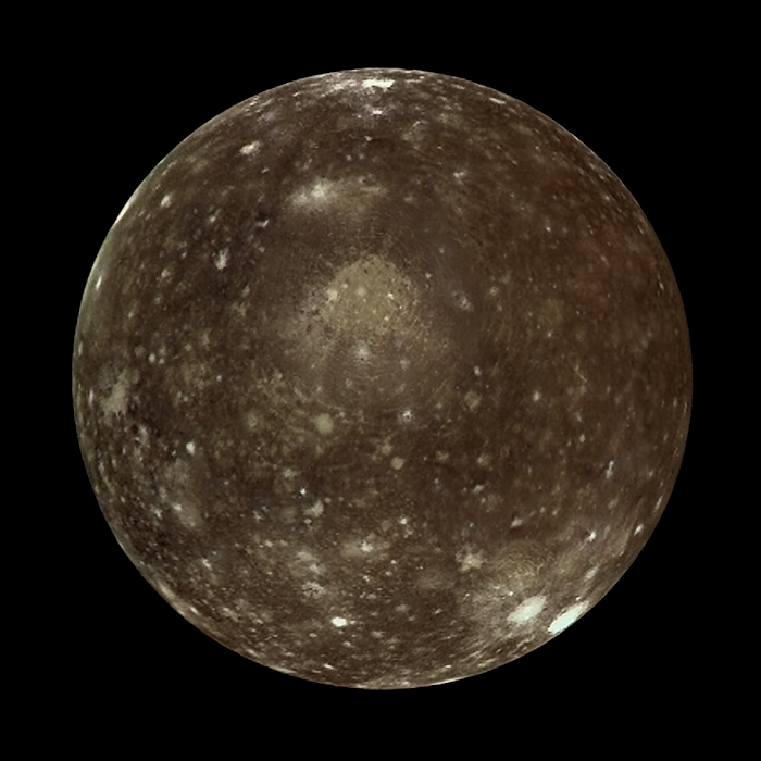
NASA / JPL / Ted Stryk
Callisto in color
Galileo captured this global view of Callisto on its 11th orbit of Jupiter, on November 5, 1997. The filters used for this image cover a broader range of the spectrum than human eyes can see. Galileo was 687,000 kilometers from Callisto when it took this image, at a phase angle of just 1°. Image scale is 6.9 kilometers per pixel. The image was reconstructed from the original data by Ted Stryk. About 10% of the right side of the disk was marred by data dropouts; Stryk reconstructed missing data from images taken through other filters.Jeff pointed out that "The only unambiguously identified features on Titan are exogenic -- fluvial, aeolian, and impact. There are no unambiguously identified features that are endogenic -- tectonic or volcanic." That is, we have very strong evidence that the surface is shaped by processes that result from the atmosphere, things like rain and wind. But so far the jury's out on whether there are internal processes going on. To be fair, Jeff pointed out, it may just be that the data isn't good enough yet. He asserted that despite the accomplishments of Cassini's four years at Saturn, "the state of imaging on Titan is similar to state of understanding of Mars after Mariner 6 and 7." Imaging is similar in extent and resolution; after Mariner 6 and 7, the jury was out on whether anything besides cratering had shaped Mars' surface.
Still, Jeff said, "When you look at features on Galilean satellites that are of similar size, they don't look very much like Titanian features -- even on Callisto." He compared images of large craters on the Galilean moons to the largest ones observed on Titan. The Galilean moons' craters were flat and degraded, a result of relaxation of a relatively mobile icy crust. By contrast, Titan's biggest craters have much steeper topography. "This implies Titan's lithosphere is stiffer than the Galileans'. In fact, the only similar-sized and -shaped crater features are on Dione and Tethys."
On Titan, Jeff said, the parallel ridges that I showed in the RADAR image above have been interpreted to be evidence of tectonic forces breaking the surface and tilting blocks of crust. On Callisto, parallel ridges and scarps are interpreted to be a part of multi-ring impact features. Could the parallel ridges and sub-circular features that make up the rough terrain, but low topography, in the Xanadu region be the fluvially eroded remnant of heavily cratered terrain like we see on Callisto? Both Titan and Callisto first formed way out in the outer accretion disks of their respective planets. Is Titan also pretty much dead in its interior?
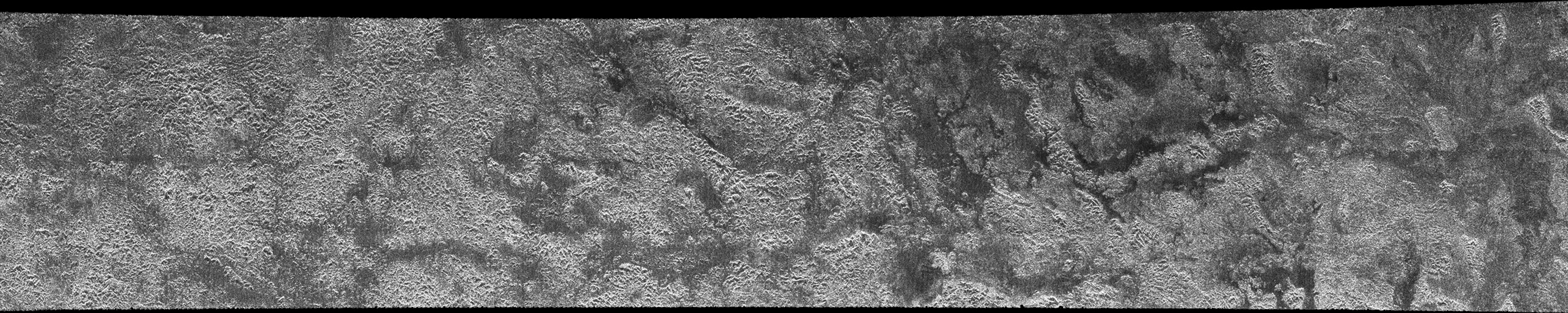
NASA / JPL
Cassini RADAR swath on Titan, flyby T13, April 30, 2006 (center right section)
his strip across Xanadu is from Cassini's RADAR instrument, in a swath captured on the T13 flyby on April 30, 2006.Finally, let me talk about the lakes. There were several talks that focused on the distribution of the lakes on Titan. In brief, there are lots in the north, and there are very much fewer in the south.
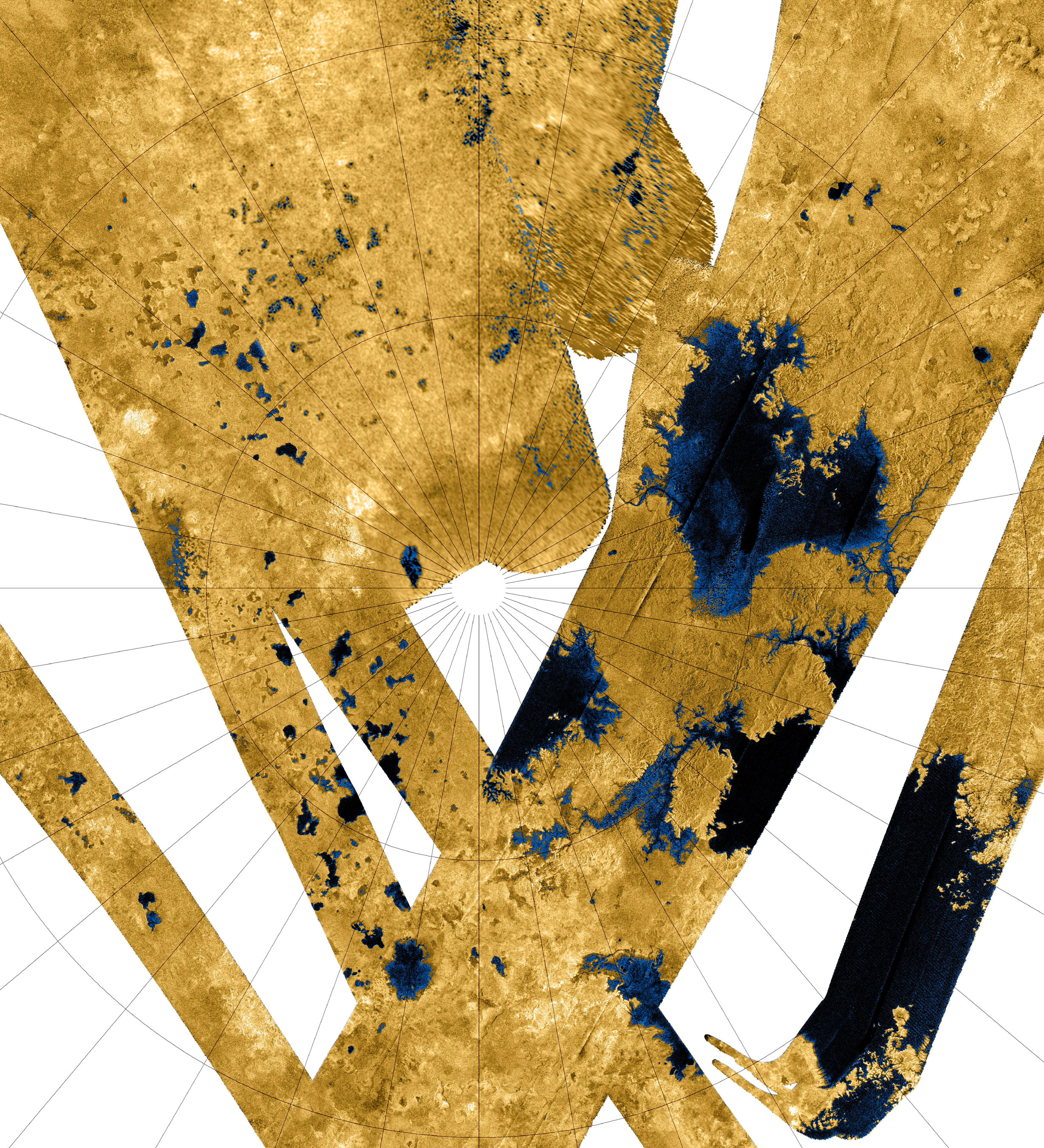
NASA / JPL
Cassini RADAR view of Titan's north pole, October 2007
This mosaic is composed of all synthetic-aperture-radar maps of Titan's polar regions acquired by Cassini to date. It has been cropped and reduced in size by 50% from an even larger mosaic available on NASA's Planetary Photojournal. Approximately 60 percent of Titan's northern polar region (poleward of 60 degrees north latitude) has been mapped as of October 2007, and of this area, about 14% appears to be covered with hydrocarbon lakes. The radar images are grayscale; they have been colored here with a color map that applies blue colors to the materials that are darkest to the RADAR instrument, and yellow colors to the materials that are brightest. This color scheme highlights the apparent lakes, but also shows that many lake-like features are not as dark as other lakes, and that darker channels appear to run down the interiors of less dark lakes.However, further investigation has produced some observations that make this seasonal interpretation problematic. In addition to the "wet" lakes in the north, there's lots of dry ones too. In his presentation, Alex Hayes showed maps of the distribution of both wet and dry lakes -- features that have the shape and some of the properties of the dark, wet lakes but are not dark. He said that three different methods used to derive the topography of the putative dry lakes have shown that they are indeed the locally lowest areas of topography, so it's quite reasonable to argue that these are places that were once filled with liquid, but aren't anymore. Here's the kicker: there are almost no dry lake beds in the south. If there are no dry lakes, then the hypothesis that the methane moves back and forth from north to south doesn't seem to hold up; there's no evidence of places in the south that should be filled by all that northern methane.
If the difference between north and south doesn't result from seasonal changes, what's its origin, then? Oded Aharonson took up the problem from there. First, just to be thorough, he showed that the asymmetry really does exist -- that there are definitely many more lakes in the north than in the south, that it's not an artifact of the spotty coverage of Cassini data. The next hypothesis he considered is that the asymmetry results from an asymmetry in topography; that there are more lakes in the north because the elevation of Titan's north polar regions is lower than the south polar regions. This isn't nutty and "it may be right," Aharonsen said. There is some evidence for it; and there's precedent, too -- it's the state of things on Mars. Next Aharonsen considered the seasonal-change hypothesis, and the problem of the lack of dry lakes in the south. That fact falsifies the seasonal-change hypothesis, he said. "You may be able to transport liquid from pole to pole, but how do you transport the hole in the ground?" This question brought chuckles from the audience.
Finally, Aharonsen came up with what he described as a slightly "crazy" hypothesis, but one that couldn't be eliminated: that the asymmetry does actually result from differences in seasons at the poles -- that summers in the north just aren't the same as summers in the south. Again, like Mars, Saturn has a pretty significant axial tilt, and it lines up with the characteristics of Saturn's elliptical orbit in such a way that the southern summers are significantly shorter and more intense than their northern counterparts. This asymmetry, Aharonsen said, could potentially result in the northern pole being wet and the southern pole being dry. But, he pointed out, "Saturn's orbital parameters are time-dependent." The seasons don't always line up with Saturn's distance from the Sun in the same way. "Every several tens of thousands of years, the situation is exactly reversed to what it is today." So, if this hypothesis is the correct explanation, then the situation must reverse every few tens of thousands of years -- the north pole would become the dry pole, and the south pole the wet one. What about the missing holes in the ground near the south pole? Aharonsen pointed out that of all the craters observed on Titan, none have been found in polar regions. Maybe the landscape at the poles gets substantially resurfaced every few tens of thousands of years as the climate shifts. Aharonsen pointed out that exactly this has been happening on Earth over the last few tens of thousands of years, as ice ages come and go and polar glaciers reshape the landscape. I agree with him that it sounds slightly crazy -- but just plausible enough to be worth investigation.
These studies will be helped by improved RADAR imaging over the south pole -- to date, the coverage is much better in the north than in the south. As winter comes to the south pole and the cameras can't be used to take images there anymore, close south polar approaches by Cassini will increasingly be given over to the RADAR team for imaging, so that situation will improve over the next two years. In fact, improvement starts soon: Alex Hayes mentioned in his presentation that Cassini will be delivering a Christmas present to the team in the form of the first-ever altimetric profile across a lake region. On December 24, the RADAR instrument will take a topographic profile across the southern pole, a profile that will go right across Ontario Lacus, the one large lake that's been spotted down there. This will be the first time that the topography will have been profiled across any of Titan's lakes.
NASA / JPL
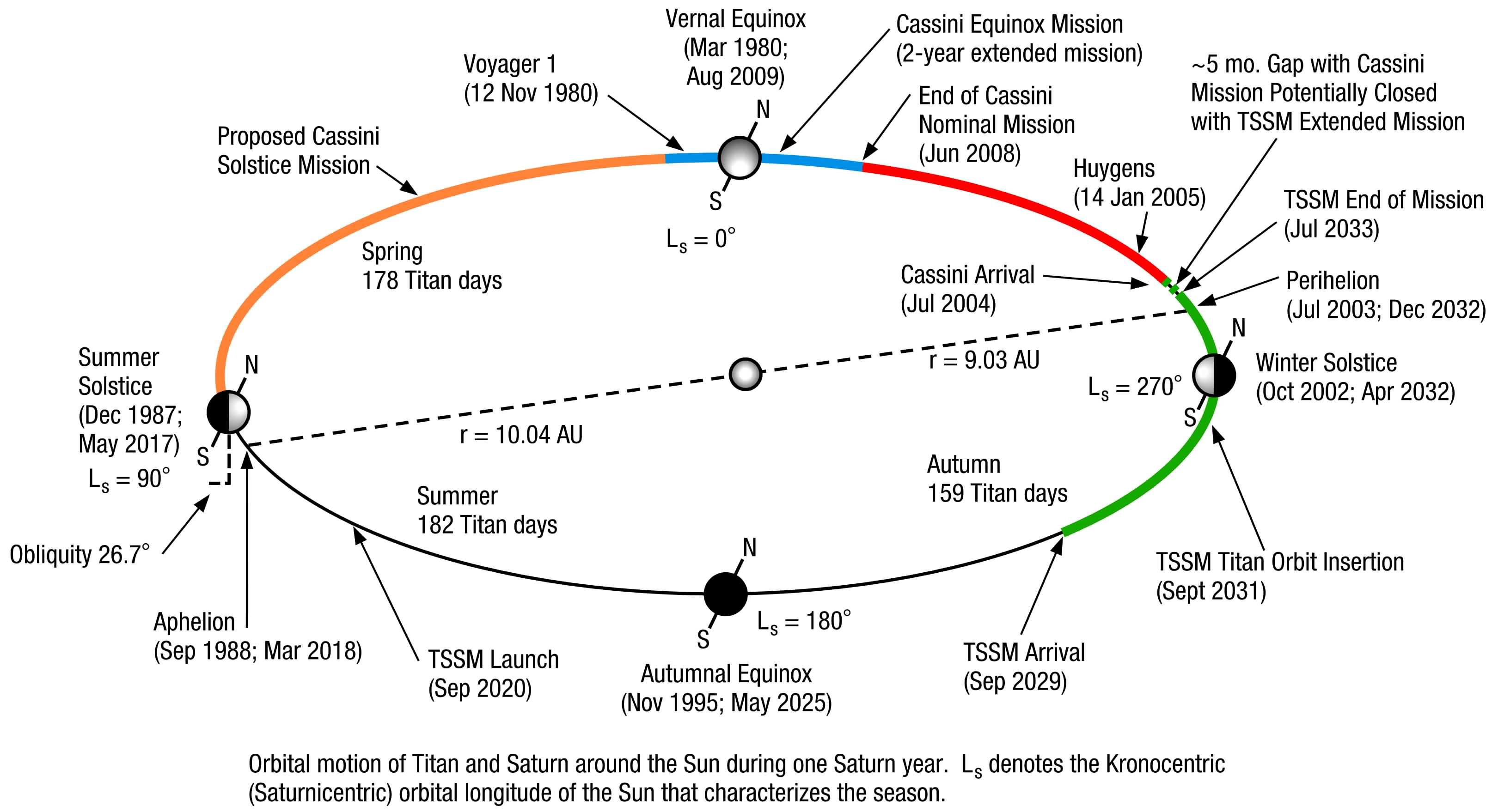
Saturn's orbit and seasons, and past and future missions
Saturn has an axial tilt and an elliptical orbit that gives it Mars-like seasons: each 29.7-Earth-year Saturn "year" contains a spring, summer, fall, and winter in each hemisphere, but the southern summer is shorter and more intense than the northern summer. Cassini's primary mission occured entirely during the southern summer (red segment of orbit). The extended mission will see Saturn through the northern vernal equinox (blue segment), which is the same part of the season in which the two Voyager flybys took place. A possible second mission extension might see Cassini at Saturn throughout the northern spring. A proposed future Titan-Saturn System Mission (TSSM) would arrive in 2029, in late southern spring.Protect Our Shared Future
You help us defend humanity and prevent asteroid impacts. Donate now to become a Planetary Defender!
Donate