See other posts from July 2009
Why Titan is so exciting
Posted by Elizabeth "Zibi" Turtle
2009/07/15 05:07 CDT
Topics:
by Zibi Turtle
Zibi Turtle is a research scientist in the Planetary Exploration group at Johns Hopkins University's Applied Physics Lab. She is an associate of Cassini's imaging team and member of the Lunar Reconnaissance Orbiter Camera team. Her research interests include impact cratering and planetary geology, e.g., lake formation on Titan, crater formation and modification, and mountain building on volcanic Io. When not sitting in front of a computer, she enjoys racing with the Baltimore Rowing Club, taiko, and playing with her nieces.
Just over five years ago, on 30 June 2004, the Cassini orbiter and the Huygens probe it was delivering to Titan went into orbit around Saturn and began detailed exploration of the Saturnian system. Over this time more and more of the surface of Saturn's moon Titan has been covered by the suite of complementary instruments, and as we learn more Titan becomes increasingly intriguing.

NASA / JPL / Space Science Institute
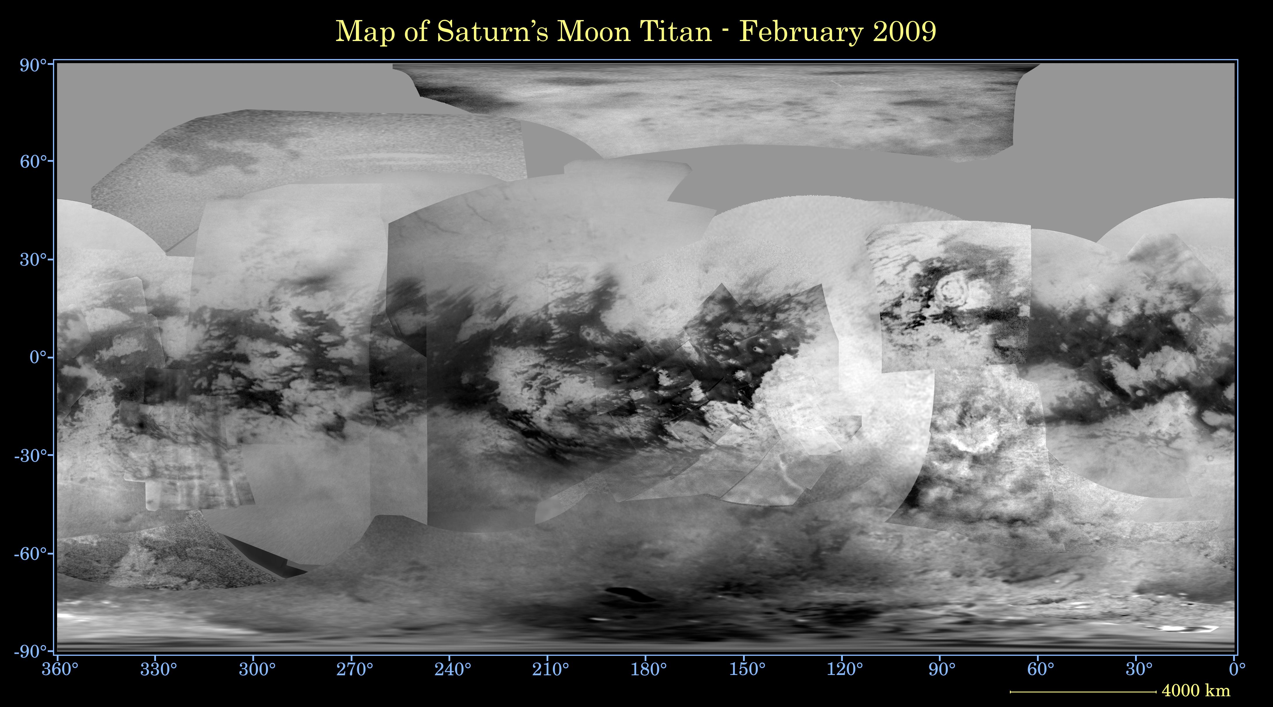
Map of Titan
Map of Titan's surface created from images acquired by Cassini's Imaging Science Subsystem (ISS) through February 2009 at a wavelength of 938 nm.
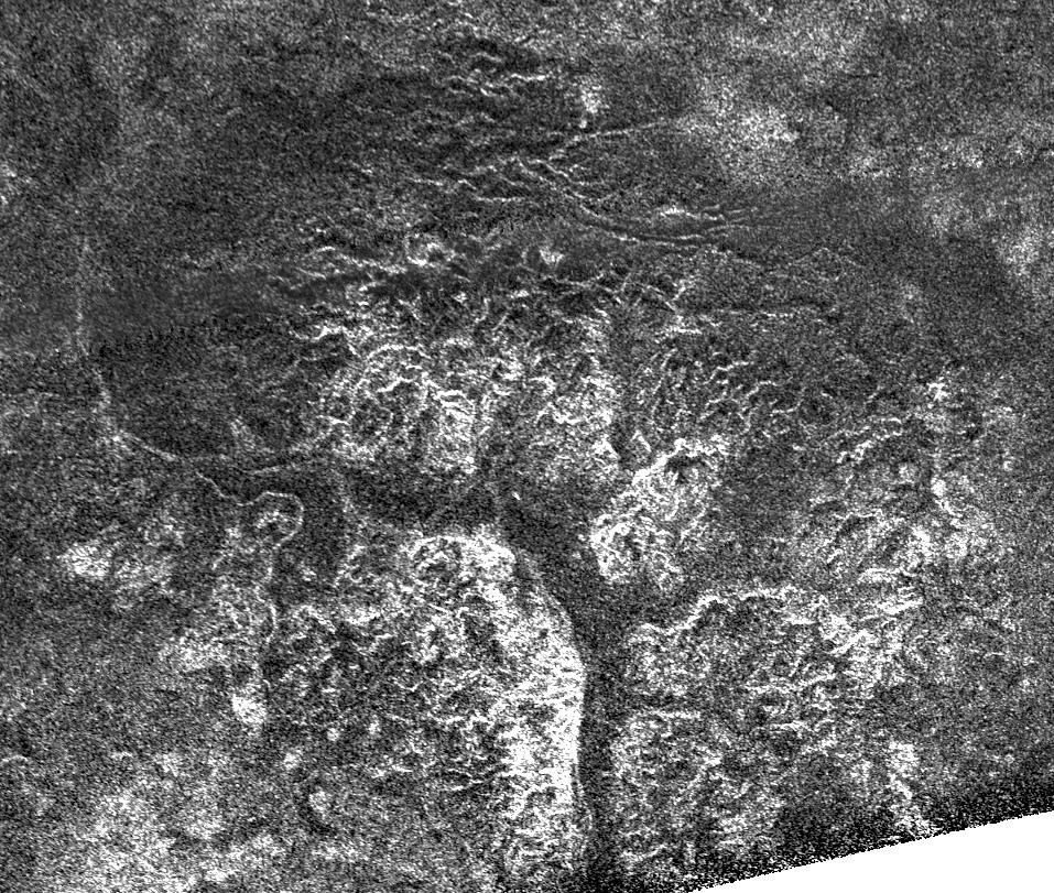
The materials are exotic: methane plays the role of water on Earth, the bedrock is composed of water-ice rather than silicate rocks, the sand-sized particles that form the dunes are complex hydrocarbon particulates, and cryovolcanism would erupt liquid water possibly mixed with ammonia. Nonetheless, thanks to Titan's unique thick atmosphere, many of the processes that shape its surface are very familiar: rainfall, the erosion of river valleys by liquid flowing on the surface, and the accumulation thereof into lakes and seas; dune formation by Titan's winds; and possibly cryovolcanism.
Valleys, lakes and seas:
NASA / JPL
Southern Canyons of Titan
Cassini synthetic aperture radar (SAR) image of an intricate system of valleys carved by rivers of liquid methane.
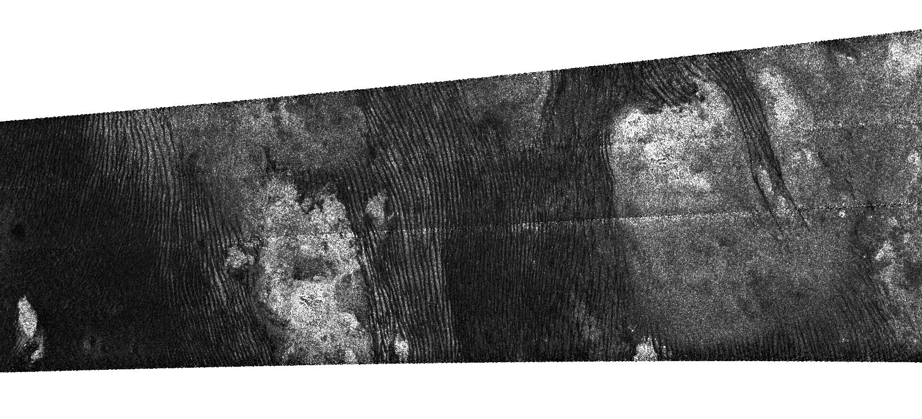
Dunes:
NASA / JPL
Titan's Dunes
SAR image of dark longitudinal dunes that have formed around higher-standing bright areas.
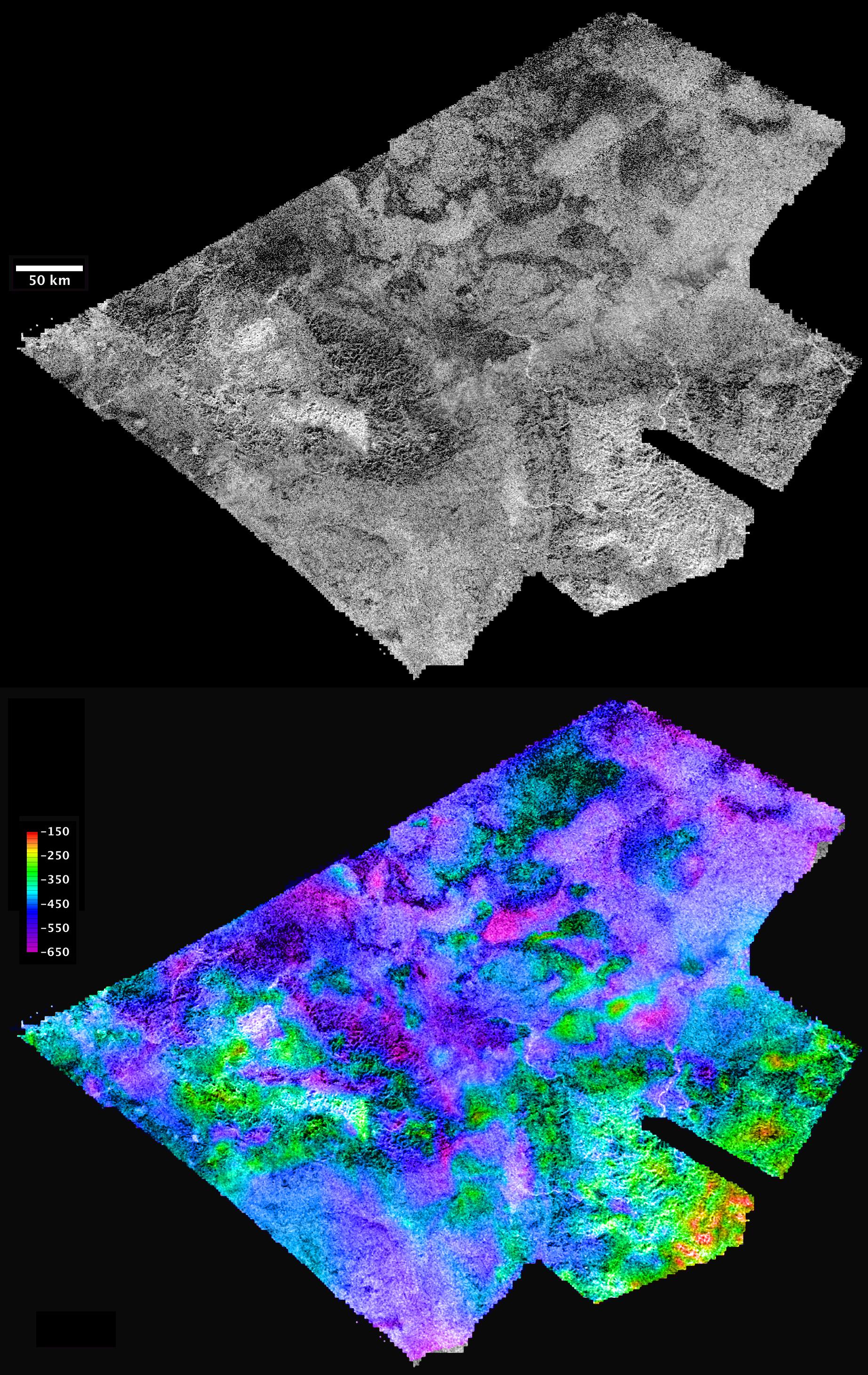
Cryovolcanism:
NASA / JPL / USGS
Hotei Arcus, Titan
SAR image and topography from a stereo-pair of SAR images acquired by Cassini's RADAR instrument of Hotei Arcus, an area that is hypothesized to have been the site of cryovolcanic eruptions.
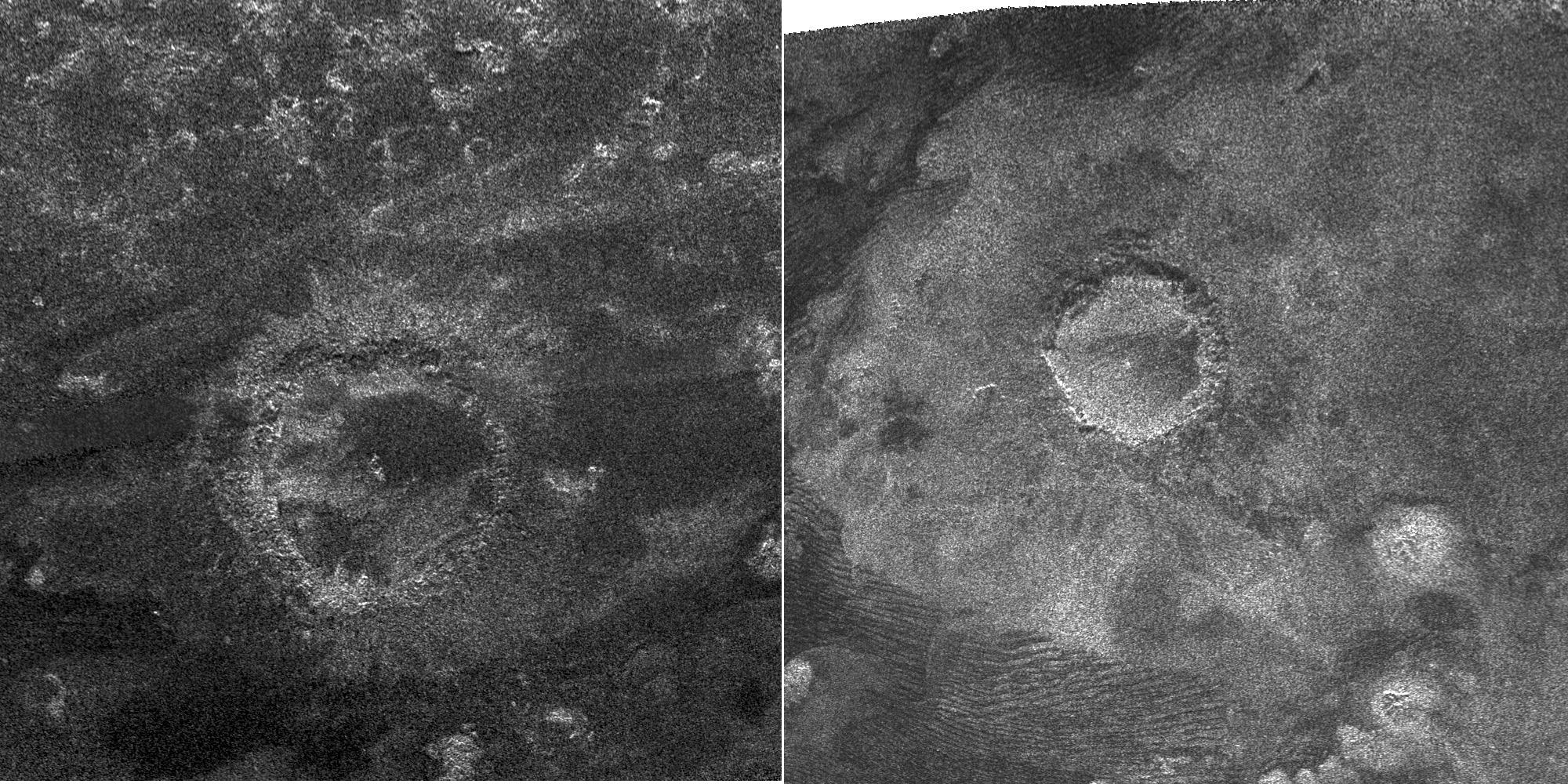
Impact craters and tectonic features, which are generally quite common on other icy satellites, have been harder to identify on Titan, likely, as on Earth, a result of modification by erosional processes.

NASA / JPL
Titan's Impact Craters
SAR images of impact craters, 112 km (left) and 80 km (right) in diameter.
On Earth, which has similar complexity in terms of geologic processes overprinting one another, we usually have the luxury of being able to explore geological structures of unknown origin in person. Even in cases where structures are not directly accessible, e.g. the Chicxulub crater buried deep within Mexico's Yucatan Peninsula, we can acquire samples via drilling and structural information through techniques such as seismic surveys. On Titan by comparison, for now at least, we are much more restricted: the Huygens probe revealed Titan's surface in great detail at a single location, and Titan's atmosphere not only obscures the surface but also limits the altitudes of Cassini's closest approaches to just under a thousand kilometers. Unraveling Titan's complicated geologic history is quite a challenge, but it is precisely this complexity that makes the exploration of Titan so exciting.

Our Curiosity Knows No Bounds!
Become a member of The Planetary Society and together we will create the future of space exploration.
Join Us
Pretty pictures and awe-inspiring science.
See More
Comments:
Leave a Comment:
You must be logged in to submit a comment. Log in now.