
 Explore Worlds
 Find Life
 Defend Earth


A.J.S. Rayl • Mar 05, 2014
Mars Exploration Rovers Update: Opportunity Cruises Through Winter Solstice, Into Year 11
Sols 3564 - 3590
The Mars Exploration Rover mission put its 10th anniversary in the rear view mirror in February and roved on into its 11th year of surface operations at Endeavour Crater. After finishing her inspection of a mysterious "jelly doughnut" rock, Opportunity checked out other outcrops in Cook Haven, continued the exploration of Cook Haven, just off Murray Ridge in the Solander Point section of the crater's rim, and cruised through the depths of winter with the Martian wind beneath her winglets.
Mars Exploration Rover
NASA / JPL-Caltech / Maas Digital
"We're looking toward celebrating the next 10 years now," said John Callas, MER project manager, of the Jet Propulsion Laboratory (JPL), home to all NASA's Mars rovers. Although he chuckled a little when he said that, other people on the mission have said the same thing, and Mars seemed aligned with the notion, at least for now.
Throughout February, a steam of wind blew a little dust off the rover's solar arrays nearly every sol or Martian day and Opportunity’s ability to take in more sunlight power for energy steadily improved. "We’ve never seen anything like this before," said Bill Nelson, chief of MER engineering. "Normally, a dust cleaning is a one or two day event and we get a jump in power. Here we've seen a continuous rise over weeks. Instead of dust building up a little bit every sol, dust has been blown off the array a little bit every sol and the power has gotten a little better and a little better and a little better."
The robot field geologist was able to rove right through the winter solstice in Mars’ southern hemisphere, where Endeavour Crater is, and come out the other side raring to go. Just five sols after the solstice, which came and went on February 14th, the solar powered robot woke up by Sun power alone, something it had never before been able to do during the bottom of a Martian winter.
Opportunity and her team, meanwhile, successfully homed in on the original location of Pinnacle Island, the mystery “jelly doughnut” rock that made the news in January. It had been just up slope from where it first appeared to the team, along with other rocks, in a place where the rover had driven. The team is all but certain that the rover knocked the rock out of place with one of its wheels.
Then, in checking out the immediate area, Opportunity found similar rocks that contained minerals indicating the past presence of near-neutral water. Although these were just early findings and among the first targets on Murray Ridge, they bolstered the idea that the near-neutral past water, that was found at Cape York last year – water much like the water we would drink on Earth – was probably all around this place billions of years ago.
“It was another good month on Mars,” summed up Matt Golombek, MER project scientist and senior research scientist at JPL. "And we have work to go."
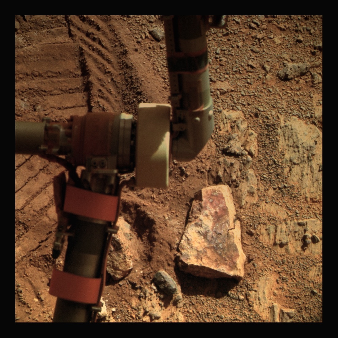
As January dawned at Endeavour Crater, Opportunity was still investigating Pinnacle Island, the now infamous Martian rock that looks like a "jelly doughnut," as Steve Squyres, MER principal investigator of Cornell University, described it. It is as bizarre a rock as this mission has come across and it caused a stir when it appeared in an image Opportunity took on January 8th in a location where it had not been just four sols or Martian days earlier.
Just 4 centimeters (about 1.5 inches) wide, the white-rimmed rock with a deep red-center seemed to have suddenly appeared out of nowhere. It was obvious it had been broken open somehow. "If you're a geologist out in the field, you carry a hammer to break up rocks and get at the un-weathered surface, because that's how you can identify the minerals," said Golombek. "At Pinnacle Island, by accident, we had a broken-off surface, which is incredibly illuminating to geologists."
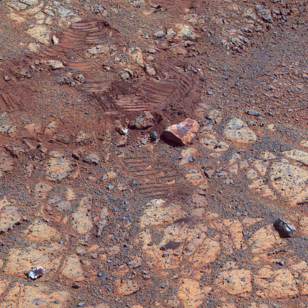
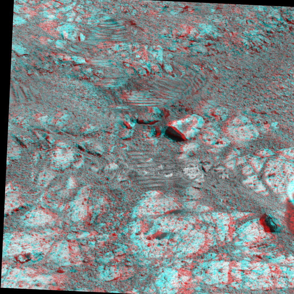
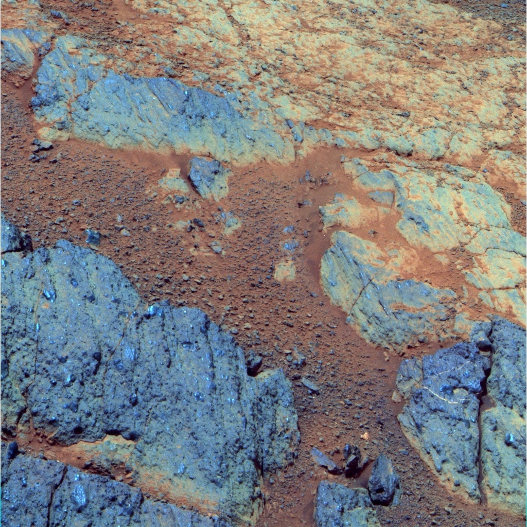
Where Pinnacle once was
These images – shown here in false color and in 3D – show the mysterious "jelly doughnut" rock, Pinnacle Island (in lower left corner) and the location where the MER team is now convinced it had been before suddenly appearing in January in a place it had not been just days before. Opportunity took this image on her Sol 3567 (Feb. 4, 2014) with the panoramic camera (Pancam), after backing away from Pinnacle Island. Just uphill (up and to the right in the image) is Stuart Island, which has a similar dark-red center and white edge. This is the area, where the rocks and tracks are, that Pinnacle Island was before the rover drove over it in early January and "tiddly-winked" it to its current location. The rover's solar panels had blocked this view while it was studying Pinnacle Island. The stereo version, second image, appears in 3D when viewed through red-blue glasses (red lens on the left). For scale, Pinnacle Island is about 1 meter (3 feet) from Stuart Island.NASA / JPL-Caltech / Cornell / ASU
The timing of Pinnacle Island's sudden appearance was impeccable and, one might say, spirited, popping up when it did right in the midst of the MER 10th anniversary presentations and celebrations. And from the data Opportunity collected and sent home, the MER scientists found that Pinnacle Island is extremely high in manganese, magnesium, and sulfur, indicating the action of water. "To our knowledge, this pretty much requires water to have concentrated those minerals in this kind of a way. It points directly to a water-processed rock," Golombek told the MER Update.
But when that water was there, they can’t yet say. "This may have happened just beneath the surface relatively recently, or it may have happened deeper below ground longer ago and then, by serendipity, erosion stripped away material above it and made it accessible to our wheels," said Ray Arvidson, MER deputy principal investigator of Washington University St. Louis.
Too strange to let be, the MER team decided to have Opportunity look for where Pinnacle Island came from and to see how much more of the story they might be able to unravel. Even on Mars rocks don't just appear, to our knowledge anyway, and nearby outcrops would no doubt hold clues.
On Sol 3567 (February 4, 2014), the robot field geologist backed away from Pinnacle Island. It took a short drive or "bump" of 2.7 meters (about 9 feet), to the southeast, and a new target dubbed Green Island.
The MER team members have come up with various naming themes throughout the mission and the targets in Cook Haven are named for places Captain Cook sailed by during his voyages of discovery in the late 1700s.
From the images Opportunity took after that drive and sent home, the MER team quickly concluded that Pinnacle Island is a piece of a larger rock that was broken and moved – or "tiddly-winked by the rover’s wheel,” as Squyres suggested in January. In the new images, they could see the original piece of rock struck by the wheel, slightly uphill from where Pinnacle Island came to rest.
"Once we moved Opportunity a short distance, after inspecting Pinnacle Island, we could see directly uphill an overturned rock that has the same unusual appearance," said Arvidson. The rover had, actually, driven right over it. "We can see the track. That's where Pinnacle Island came from."
"We saw the break and the rock where it came from and there were several other rocks next to it that looked similar – Stuart Island was one," added Golombek.
The MER team decided to Send Opportunity there next. But for the rest of the first week of February, the rover focused on Green Island, taking some 13-filter Panoramic Camera (Pancam) images and other pictures with her Navigation camera (Navcam). On Sol 3569 (February 6, 2014), she used her Rock Abrasion Tool (RAT) to brush a spot on Green Island. Then, as usual, followed the brush with now routine pictures and chemical analysis. First, the rover took out the Microscopic Imager (MI) to snap a series of pictures for a mosaic, and then placed the Alpha Particle X-ray Spectrometer (APXS) on the target to determine the rock's chemical make-up.
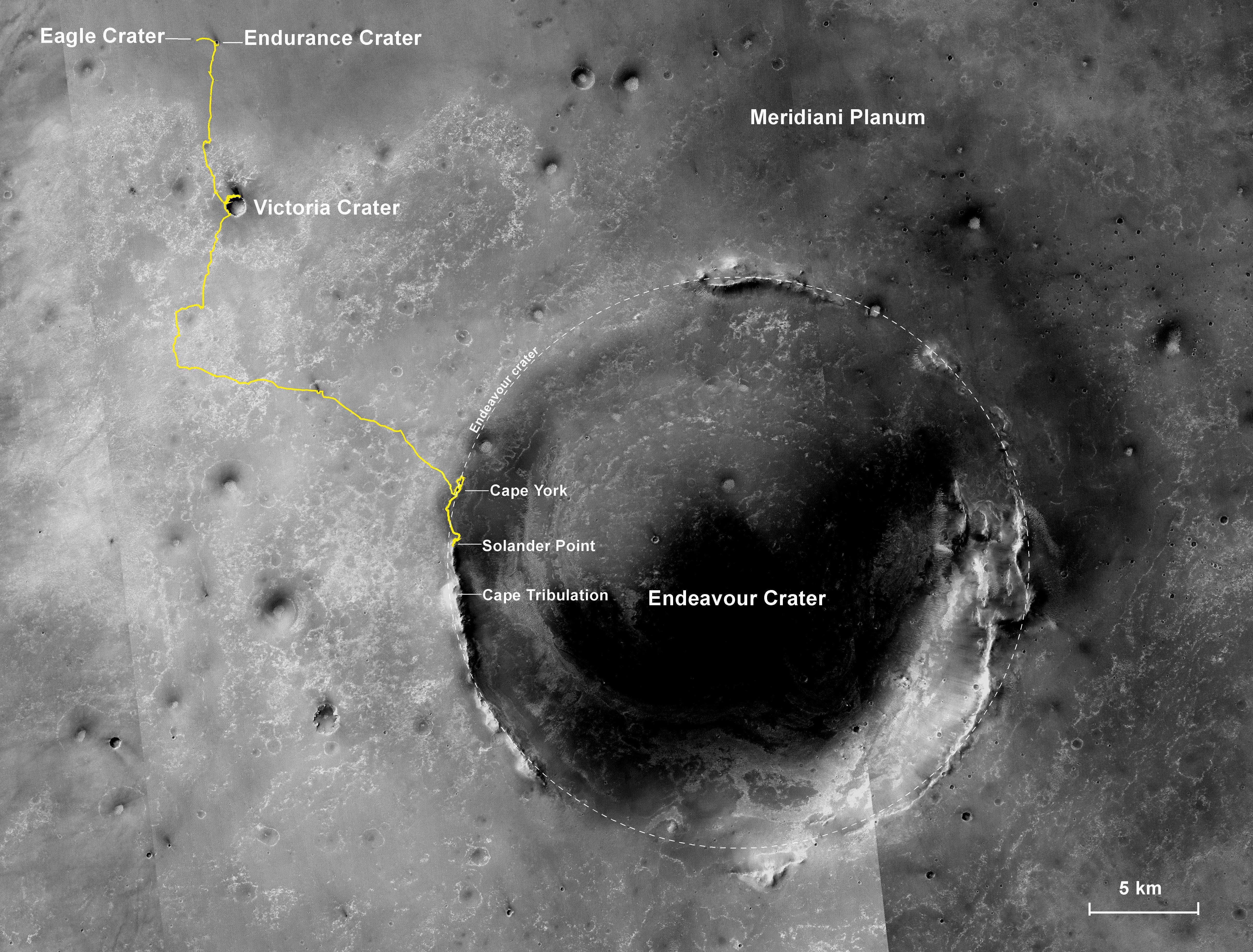
The adventure so far
The gold line on this image shows Opportunity's route from the landing site, in upper left, to the area it is currently investigating on the western rim of Endeavour Crater, Murray Ridge along the Solander Point segment. The base image for the map is a mosaic of images taken by the Context Camera on MRO, built and operated by Malin Space Science Systems. This traverse map was made by Larry Crumpler, a MER science team member, at the New Mexico Museum of Natural History & Science, Albuquerque. If all goes as planned, Opportunity will depart for Cape Tribulation in the spring.NASA / JPL-Caltech / MSSS / NMMNHS
As the second week of the month began, Opportunity gathered a final 13-filter Pancam image of the brushed spot on Green Island, then departed. Backing uphill for about 3 meters (9.8 feet) on its Sol 3571 (February 8, 2014), the rover stopped in a position where it could access Stuart Island, a rock that "looks kind of like a pork chop," Callas said. the robot field geologist began its up-close investigation of Stuart Island on Sol 3573 (February 10, 2014), with a MI mosaic and APXS placement for an overnight integration. During the next two sols, she repeated this procedure on target spots just off-set from the original target spot.
The data indicate that Stuart Island is similar in composition to Pinnacle Island, as the scientists expected. Even so, since they are “kind of on their own” and not in place or in strata, the MER scientists can't conclude much more about them, said Golombek. "We can't really put Pinnacle Island into context other than the fact that many of the rocks that we've seen indicate, similarly, water was involved in their formation," he said. "So we're seeing more evidence for this watery early environment."
More signs of water is, of course, welcome news. But it's not really that surprising since the rover is roaming around ancient Noachian terrain in this rim section of the crater. Scientists have long known that Endeavour Crater was formed during the Noachian Period, an early phase of Mars' evolution, some 3.7 to 4.1 billion years ago, when the Red Planet was warmer and wetter, and a more neutral pH water flowed across the surface and filled craters, forming lakes – unlike the salty sea for which Opportunity found evidence in 2004 on much younger terrain. It was a time when Mars was believed to have been more like Earth.
"Virtually all of the rocks on Murray Ridge and Cape York are Noachian to our knowledge," said Golombek. "It is plausible there could be younger [events] that have gone on [to impact the rocks and outcrops on the rim segments], but we don't have information to support that,” he added. “The rim is poking up and Endeavour is clearly a Noachian crater. These rocks appear older and are sticking up from underneath the younger sulfates that formed in acid rich waters, so that pretty much requires this stuff [on top] to be of that early period."
The water on Mars that planetary scientists now generally believe was once plentiful enough "affected many areas" around the planet and "produced the clays that we discovered in Whitewater Lake and are seen in the near infrared spectra from many other locations in the ancient Highlands of Mars," said Golombek. And the quality of water that flowed way back then is meaningful and significant. "The presumption here is that the earliest history of aqueous activity on Mars was neutral pH and thus, by extension, much more favorable to the origin of life than – battery acid," as Golombek laid it out.
Stuart Island
The wheel track beside Stuart Island helps tell the story: Opportunity drove over this small rock pile in early January and one of the rocks cracked apart. One of the pieces, Pinnacle Island, was knocked downhill, ostensibly by the rover's wheel. The robot field geologist took this image with the Pancam and author and planetary outreach educator and MER poet Stuart Atkinson, a member of UnmannedSpaceFlight.com, processed it here in rich Martian technicolor. No relationship between the 'Stuarts' here, though the human Stuart certainly wouldn't mind if there was. For more of Atkinson's work, please see his The Road to Endeavour blog at: http://roadtoendeavour.wordpress.com/NASA / JPL-Caltech / Cornell / ASU
Certainly one can argue that we know now that there is life that can survive, even thrive in battery acid-like conditions on Earth. "But why would you emerge from there when you have a Petri dish next door?" asked Golombek.
As Opportunity worked her way up Murray Ridge during the last couple of months, heading for Cook Haven, she saw lots of breccias. The MER scientists think they are similar to the breccias found at Cape York, which they hypothesize were hurled up by whatever hit the surface and created the crater, a strata they call Shoemaker Formation. And “by inference,” the scientists think the breccias on Murray Ridge are, therefore, “related to the impact that formed Endeavour in the first place,” said Golombek.
The Whitewater Lake layer, which held the clay minerals on Matijevic Hill at Cape York, and which is the oldest known rock strata the rover has found on the mission, is thought to be from before the impact, perhaps from the earliest part of the Noachian Period.
“But how Pinnacle Island or Stuart Island over here in the Solander Point section of the crater's rim relate to what Opportunity found on Matijevic Hill is “not clear,” said Golombek, “because we haven't had a really nice clean outcrop to look at the overall textures and form of the rock to try and compare it. This could be a little window of breccias or it could be Whitewater Lake. We just don't know yet.”
Opportunity will soon make her way up the boulder-studded rise “at the edge of what makes Cook Haven this little basin," as Golombek described it. “The hope is as we make our way up that hill we will start seeing more rocks that will make this clear,” he said.
The MER team christened that rise the McClure-Beverlin Escarpment, in honor of engineers Charles "Jack" Beverlin and Bill B. McClure, the first recipients of the NASA Medal of Exceptional Bravery. On February 14, 1969, the launch vehicle carrying Mariner 6 began losing pressure fast and was starting to crumple on the launch pad. A faulty switch had opened the main valves on the Atlas stage releasing the pressure that supported the Atlas structure, according to a NASA account of the incident.
At risk of the 12-story rocket collapsing on top of them, McClure and Beverlin, NASA contractors from General Dynamics, started pressurizing pumps and saved the structure from further collapse. The Mariner 6 spacecraft was removed, put on another Atlas/Centaur, and launched on schedule.
"Our team working on Opportunity's continuing mission of exploration and discovery realizes how indebted we are to the work of people who made the early missions to Mars possible, and in particular to the heroics of Bill McClure and Jack Beverlin," said rover team member James Rice, of the Planetary Science Institute, in Tucson. "We felt this was really a fitting tribute to these brave men.”
Whitewater Lake rocks
This false color image, which Opportunity took with her Pancam back in 2012, shows a few of the light-toned, flat Whitewater Lake-like rocks that Opportunity saw all around Matijevic Hill in 2012-2013. The blue areas are the surface splotches that distinguished these rocks, which the team found to be harboring evidence for the ancient clay minerals that the mission hoped to find. The Whitewater Lake rocks represent the oldest rock unit any rover has ever uncovered on Mars.NASA / JPL-Caltech / Cornell / ASU
As winter raged in the northern hemisphere of Earth, knocking out electricity, battering buildings, and freezing folks around the planet, up on Mars, the winter was rather mild, even turned into something of a ho-hum for Opportunity. The winter solstice in the southern hemisphere of Mars, where Endeavour Crater is located, came and went February 14th, the rover's 3,577th day of exploration, and the robot field geologist didn’t seem to even notice.
In addition to the temperate winter, Opportunity has been lily-pad hopping, parking on north-facing slopes, arrays angled skyward, and basking in the winter Sun at every stop. For this time of year, the rover was power positive plus and as it headed into the very depths of the Martian winter, its energy levels were increasing.
Opportunity had gotten a dust cleaning in January and cleaning events continued as February took hold. The day after the solstice, the rover was taking in 60% of the sunlight fuel hitting her arrays and producing more than 385 watt-hours of power, plenty enough energy to rove on. “It's still cold. It's still dark on Mars, but we just have cleaner solar arrays that make things better, giving the rover the ability to produce more power," Callas said.
All that energy may have made Opportunity a little giddy. The robot suffered two amnesia events back to back on Sols 3576 and 3577 (February 13 and 14, 2014), Callas reported. Actually, this is a familiar issue with which the rover engineers have experience managing. It’s caused by corruption in the rover’s Flash memory, something Spirit suffered in previous years, just as many of us have suffered with our computers and smart devices here on Earth.
Basically, the corruption causes the rover to shut down and that erases anything in Flash, which is a non-volatile computer storage medium designed to be electrically erased and reprogrammed. The MER software engineers were able to fix Spirit’s issue by reformatting the Flash. However, as reported in previous MER Updates, the problem has to become almost permanent before reformatting will work. That’s because if the corrupted section happens to function normally during the reformatting, the corruption will not be fixed. “As long as these amnesia events remain intermittent, then we live with them," said Nelson.
With a relatively simple workaround however, the science is saved during these bouts of amnesia, although some engineering telemetry does get erased. "We have our amnesia detector on the rover which catches these and we plan for a second readout of the APXS data, which it's saved in the APXS, and recover the science," Callas explained.
Interestingly, Opportunity’s amnesia events have only occurred during late evening wake-ups, after the rover has been dozing while the APXS is analyzing or integrated on a target. “Usually, we'll let the APXS run until about 11:30 at night local time, and then we wake up the rover and turn the instrument off, then shut down [the rover] and go into a DeepSleep,” said Nelson. “It's on that wake-up, roughly around 11:30 when we've had these amnesia events." Temperature may or may not be a cause or the cause. "We don't know," he said.
While Opportunity had an amnesia event just back in January of this year, on Sol 3551 (January 19, 2014), prior that it had been more than a year since she lost her short-term memory. “We’ve only had seven or eight of these amnesia events to date with this rover,” said Nelson. That means the rover may continue to suffer these amnesia events from time to time, for a good long time, before reformatting makes any sense.
The rover engineers do have some concern about other incidents on Opportunity involving the Flash memory system that Spirit didn’t experience. "These were Flash memory induced resets, essentially power cycling events," said Nelson. "We still don't have a good clue as to what the cause of those were, but we haven't seen one in more than a year, and at the moment, we're just grateful we're not experiencing them.”
Other than those annoying little memory lapses, this veteran rover is "otherwise in good health," said Callas.
NASA / JPL-Caltech / Cornell / ASU
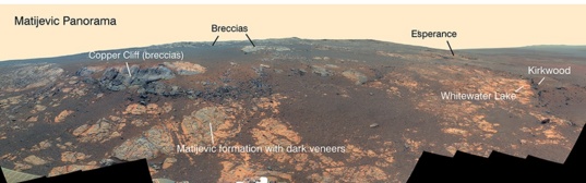
Noachian time travel at Matijevic Hill
Opportunity used her Pancam to capture this false-color panorama of the Matijevic Hill area on the Cape York segment of the western rim of Endeavour Crater. Some of the outcrops that the rover examined are labeled. The breccias are jumbled rocks amalgamated together, interpreted at this site as material tossed by the impact that excavated the crater during the Noachian Period some 4 billion years ago. The component images for this scene were taken during the interval Nov. 19, 2012, through Dec. 3, 2012.Opportunity continued her investigation of Stuart Island without missing a beat and by Sol 3578 (February 15, 2014), her work there was done. The robot field geologist stowed the IDD, backed up, turned slightly and bumped forward toward Anchor Point, a soils target, a short 1.6 meter drive plan that ended with the rover’s right front wheel on an adjacent, fractured rock nicknamed Sledge Island. The rover then “made two 90-degree turns of the right front wheel only” and crushed and separated the fragments, said Nelson.
“We call it Sledge Island, although some people call it Sledgehammer Island because we deliberately drove over it and shattered it,” noted Callas.
“The point was to try again to get a fresh surface with Sledge," said Golombek. After succeeding, Opportunity hunkered down over the broken rock and took extreme close-up pictures with its MI of the freshest surface it could see and followed up with a series measurements with the APXS to see if it was like Pinnacle Island and Stuart Island.
Power rich as she was for this time of year, Opportunity was facing a future as bright as it possibly could be – and it just kept getting better as February progressed – as if the mission's lucky star was shining down the whole month. The winds continued to blow over the rover, sol after sol, gently removing a little more dust with each pass.
On Sol 3582 (February 19, 2014), just five sols after the winter solstice, Opportunity woke up on her own solar power, establishing an impressive record for all future solar-powered rovers on Mars. "Historically, we have considered the arrival of spring to be when we get our solar array wake-ups, but we're getting them now, so we're kind of thinking we're done with winter already – even though this is not really a seasonal effect," said Callas
"This has been, in a sense, a short winter for us," agreed Nelson. The continual dusting throughout February resulted in Opportunity getting higher performance from her solar array than the previous two winters – "and that,” said Nelson, "is pretty exciting."
Once Opportunity finished her inspection of Sledge Island, on Sol 3585, (February 22, 2014) she rotated her right front wheel a couple more times to further crush and break up the rock pieces, putting just 0.32 of a meter on her odometer. The rover then backed up to take some more images and APXS analyses.
On Sol 3589 (February 26, 2014), Opportunity drove back to Stuart Island to crush it, using her left front wheel this time. Then she drove toward a little ledge of outcrop called Cross Sound, logging a total of 4.37 meters by the time she came to a stop in front of the target.
The MER scientists were drawn to Cook Haven because of the signature of clay minerals detected by the Compact Reconnaissance Imaging Spectrometer for Mars (CRISM) onboard the Mars Reconnaissance Orbiter, and mapped to that specific location by Arvidson, a co-investigator for CRISM, who had also created a mineral map that led the team to Matijevic Hill back in August 2012. Opportunity has now spent a couple of months checking out rocks and outcrops in the Murray Ridge area, but the scientists still have a lot of work to do.
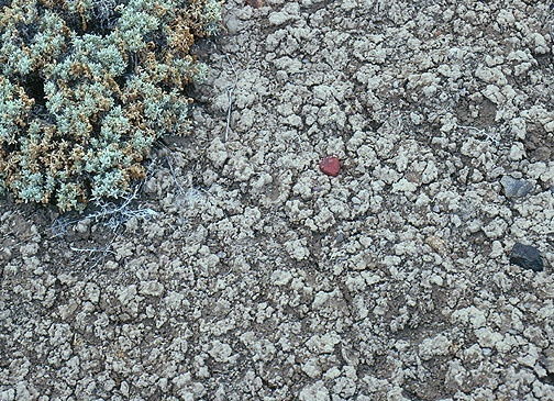
Smectite on Earth
Opportunity is on the hunt for the clay mineral smectite on Matijevic Hill and the story behind how it formed. One theory is that it is the end result of an impact that produced an enormous amount of heat and steam, which then transformed some of the ejecta to clay. Time and more investigation will tell. Meanwhile, this is a close up image of the crinkly, cracked surface typical of a soil rich in smectite clay on Earth.University of Pittsburgh / Norris W. Jones
Opportunity has not yet come across anything that immediately resembles the Whitewater Lake unit found over at Cape York – the flat light-toned rocks that featured distinctive surface splotches. Those rocks, representing the oldest rock unit, the oldest geologic time any Mars rover has explored, turned out to be harboring the clays. But, so far, on Murray Ridge and at Cook Haven, "we really haven't have a good look yet at a lot of exposed rock yet," Golombek said.
Chalk that up to the required balance between engineering and science demanded by the winter. “We made it up through the breccias at Murray Ridge and we’ve been concerned being on north-facing slopes, so we’ve gone to the first rock we’ve come to,” Golombek said. “We just haven't had a chance to look at a lot of exposure yet.”
That noted, it looks like these rocks “may be strata that may in some way be layered," Golombek said. "At first blush, that would suggest something like Whitewater Lake or a sedimentary environment. Now that's not verified, but that's the point, to go and see. If [these outcrops represent] the clay carrier, then we want to figure out the environment in which those clays formed. Were they carried in the water to there or were they alteration products in place? That's the grit of the geology we're trying to figure out. By going up the slope and looking at more rocks in this area, we hope to try and figure out what those strata are and more specifically what the environment was.”
As February began to fade, Opportunity finished her examination of Sledge Island and was starting “to wander up the hill," said Golombek at month’s end. Driving up the McLure-Beverlin Escarpment, the rover will be on the lookout for "broader outcrops that will give us the textures and fabrics that will tell us more about what those deposits are," said Golombek.
Martian "jelly doughnuts" aside, the notorious Martian winds were blowing on to be the big news of February 2014. From the beginning of the month to the end, Opportunity's power just kept getting better. "It's the first time in the mission that we've seen a gradual and continuous increase in our dust factor on the rover," said Nelson. "An increase is a good thing – that's the percentage of the sunlight gets through and as the number gets bigger, that means the more sunlight gets through.”
Why Opportunity has been experiencing this ongoing dusting is anybody's guess right now. "We seem to be in some kind of a wind channel," said Nelson. "We’re thinking it’s some combination of the rover’s position on the crest, on the edge of the crater, and the way the winds are blowing or circulating through Endeavour."
The windy winter weather seems highly unusual compared to Opportunity’s past Martian winters when winds were scarce. "It may be this windy all the time here," suggested Nelson. "But that's pure speculation. All I can tell you is the result we see: the rover is continuing to generate more and more power every sol and we've seen our power increase significantly, by around 100 watt-hours more of energy just in February."
As March blows in, it's fair to say that no one on the team had any issues whatsoever with the newly discovered Martian winds of winter at Murray Ridge. Opportunity is currently producing an estimated 472 watt-hours – a little less than half its full capability.
NASA / JPL-Caltech / Cornell / ASU
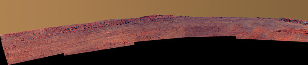
McClure-Beverlin Escarpment
Once the robot field geologist completes her check out of the McClure-Beverlin Escarpment, the plan remains the same: Opportunity will drive on to an area about 580 meters further to the south that glows bright with clay minerals in the orbital CRISM data and the mineral map produced by Arvidson. And it won't be too long before the team directs the rover even further south, Golombek said, to Cape Tribulation where CRISM data indicate the mother lode of smectite awaits Opportunity.
In other MER news, the mission will go through its biannual Senior Review at NASA Headquarters in March. Basically, all active missions routinely go through this procedure, wherein each mission team submits an extended mission proposal outlining the science it expects to be able to do during the next two years for its proposed budget. specially selected committees then review the proposals and, depending on budget limitations, either grant them or end the mission. This will be MER's 9th mission extension proposal.
Beyond MER's public appeal and the global star status both Opportunity and Spirit have achieved, Opportunity is not only still highly active but is uncovering some of the most important discoveries of the entire mission. And, it's the only rover exploring the really ancient Noachian terrain, the key time in Mars' history, the time when Mars was warmer and wetter, the time everyone wants to know about and what happened. We'll let you know what happened in the next MER Update.
Let’s Go Beyond The Horizon
Every success in space exploration is the result of the community of space enthusiasts, like you, who believe it is important. You can help usher in the next great era of space exploration with your gift today.
Donate Today