
 Explore Worlds
 Find Life
 Defend Earth


A.J.S. Rayl • Feb 06, 2013
Mars Exploration Rover Update: Opportunity Quietly Completes 9 Years Uncovering More Evidence of Water
Sols 3178 - 3208
Mars Exploration Rover
NASA / JPL-Caltech / Maas Digital
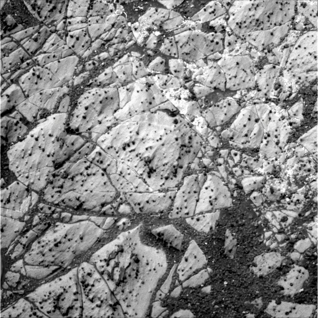
With its robot nose to the Martian grindstone, Opportunity completed its ninth year of working on Mars in January, making another significant science discovery in tiny white veins on Matijevic Hill as the Mars Exploration Rover (MER) mission rolled on into Year 10.
"The big news of the month are the veins - they're calcium sulfate," Steve Squyres, MER principal investigator, of Cornell University, told the MER Update. "The thing that's incredibly cool here is you have these little, thin calcium sulfate veins that clearly show water flowing through cracks in the ground here." As findings go, he added, "this is a big one."
The small veins are in the same flat, light-toned Whitewater Lake rock unit that is harboring the clay minerals Opportunity came to find at Endeavour Crater. With help from a visible infrared spectrometer called the Compact Reconnaissance Imaging Spectrometer for Mars (CRISM) onboard the Mars Reconnaissance Orbiter (MRO), the rover team successfully ground-truthed the presence of those clay minerals, grabbing that scientific brass ring in December.
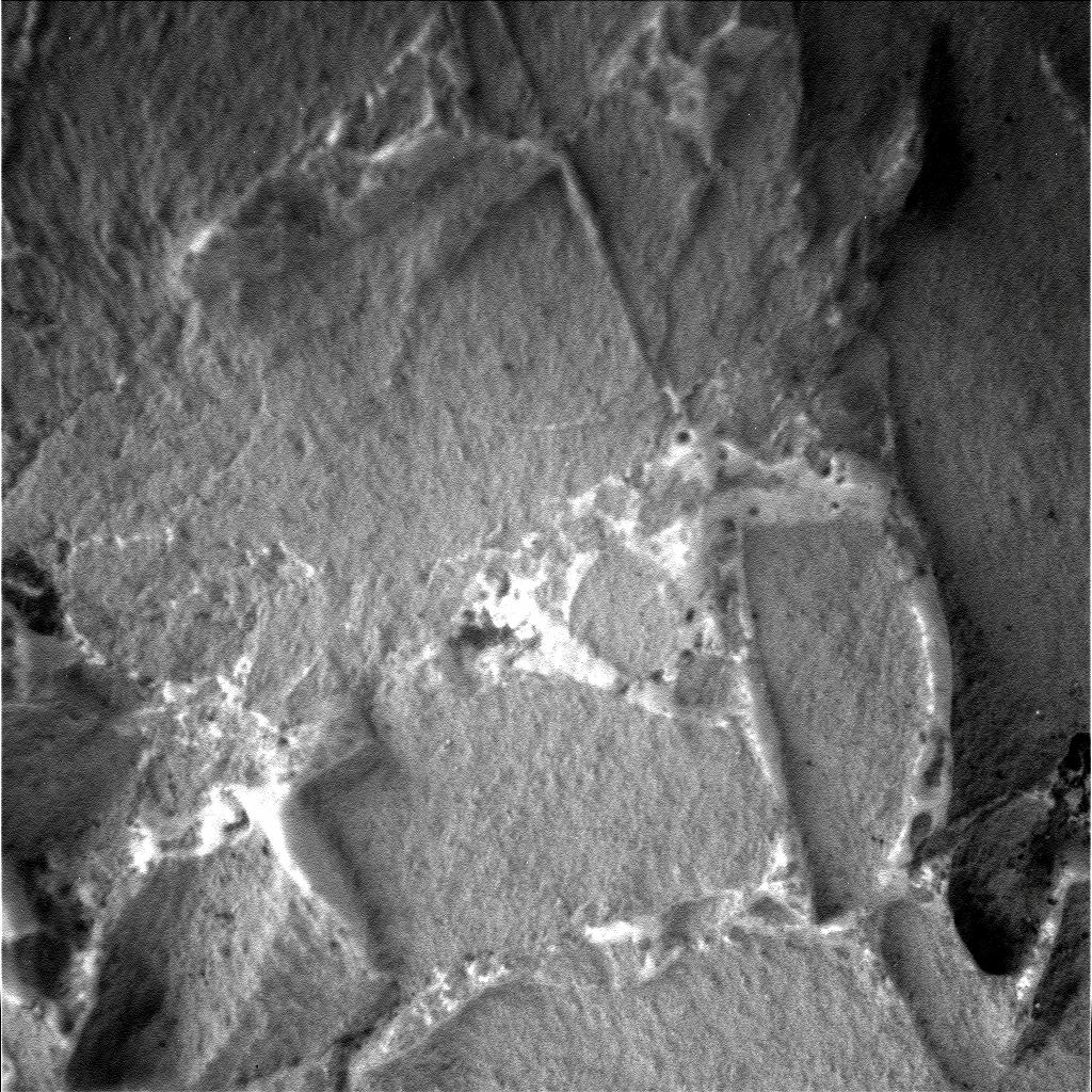
Where water once flowed
Opportunity took this close-up picture of the tiny veins running through the Whitewater Lake outcrop with her Microscopic Imager. Later data collected by the rover released that the veins are calcium sulfate. "It could be gypsum and it could be something else," said Squyres. "Our suspicion is that it's probably gypsum, but the calcium sulfate finding is solid. This is a big one."NASA / JPL-Caltech
Opportunity is, it seems, finding signs of past water everywhere around Endeavour Crater. From the looks of things, all of these minerals may have formed in a wet, low-acidic environment during Mars early history, a much more life-friendly environment than any of the past water environments the rover has found.
The rover has encountered veins at Endeavour before. Not long after arriving at the 22-kilometer (14 mile) diameter hole in the ground, it found a large vein running through the ground, in the outer area or apron of the crater rim called the Bench. Homestake, as it was called, turned out to be gypsum, a mineral that only forms in water. And it was the rover's first major "slam dunk" evidence of flowing water at the big crater, as Squyres had defined it then.
"But these are different than the big veins like Homestake," said Squyres. "They are found in a different material and are potentially a different age. They could be older than Homestake. We don't know that for sure, but the geometry and the setting are different," he said.
Nevertheless, Squyres and Ray Arvidson, MER deputy principal investigator, of Washington University St. Louis, both suspect that these tiny veins, like the much bigger Homestake, probably are made up of gypsum. If they are gypsum like Homestake, it would indicate the water environment was "pretty extensive," according to Arvidson. However, both scientists cautioned that the study of these veins is still a work in progress. Neverthless, "the calcium sulfate finding is solid," said Squyres.
The other big news of the month is, of course, Opportunity's 9th anniversary of roving and exploring Mars. Nine years into a 90-day mission is really something to write home about. But to be nine years into a 90-day mission and still conducting extraordinary science and uncovering what could turn out to be one of, if not the biggest water stories on the mission is, well ... nothing less than amazing. Certainly, it's testament to what's possible when people go above and beyond to achieve something and, perhaps, the stars align from time to time.
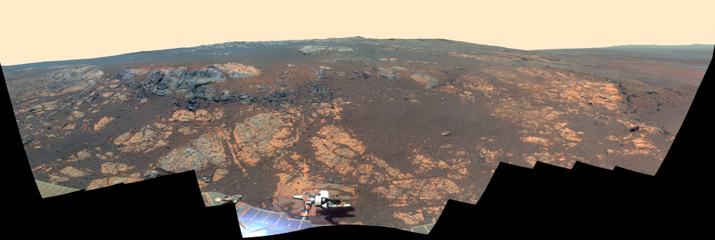
NASA / JPL-Caltech / Cornell / ASU
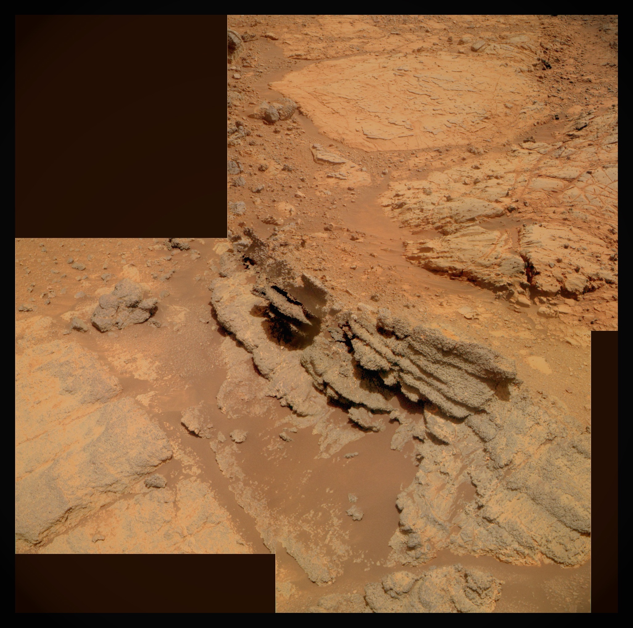
Matijevic Pan
As Opportunity neared her 9th anniversary of landing on Mars on January 24, 2013, the rover was working in the Matijevic Hill area seen in this panorama. Named for JPL's Jake Matijevic, who was one of the creators of Spirit and Opportunity, the hill is an area within the Cape York segment of Endeavour's rim. The rover ground-truthed the presence of clay minerals detected from orbit here last month in a unit of rock the team calls Whitewater Lake. This view is centered northwestward, toward the crest of Cape York and extends more than 210 degrees from left to right. It encompasses most of the terrain traversed by Opportunity during a "walkabout" in October and November 2012 to scout which features to spend time examine more in-depth. Two of the features investigated at Matijevic Hill are Copper Cliff, the dark outcrop in the left center of the image, and Whitewater Lake, the bright outcrop on the far right. Opportunity took the component images for this mosaic with her stereo panoramic camera (Pancam) from her Sol 3137 (Nov. 19, 2012) through her Sol 3150 (Dec. 3, 2012). The view is presented in false color to make differences between materials easier to see.Spirit and Opportunity's original assignments were to survive and work for three months and drive 600 meters (less than one quarter of a mile) between the two of them. Charged by NASA to "Follow the Water," the MERs primary science objective was to find evidence for past water environments. Both robot field geologists did just that during their primary missions: Opportunity wound up roving across the floor of an ancient salty sea; Spirit found evidence for water rising up from underground and circulating through surface rocks in a once volcanically active Gusev Crater.
More than the rovers' longevity is the science they have returned home. "I have said this before but what's most important is not how long Spirit and Opportunity lasted or even driven, but how much exploration and scientific discovery they have accomplished," offered John Callas, MER project manager at the Jet Propulsion Laboratory (JPL), where all the American rovers have been "born."
Spirit at Troy from above
In this picture of Home Plate, taken by the HiRISE camera onboard the Mars Reconnaissance Orbiter, you can easily see the stark white figure that is Spirit to the left (west) of the geologic formation in this image enhanced by Stuart Atkinson. Look carefully and you can actually see a bright trailing leading to Spirit, the result of the broken right front wheel being dragged through the dirt, churning up brighter material beneath. See Atkinson's On the Road to Endeavour.NASA / JPL-Caltech / UA / enhancement by S. Atkinson
Spirit always had the tougher road to hoe, because Gusev Crater is more rugged and the climate harsher than at Meridiani Planum. Throughout the years, both MERs showed unbelievable mettle as they were granted one extension after another after another to continue their respective expeditions on opposite sides of the Red Planet.
"Spirit explored just as we would have, seeing a distant hill, climbing it, and showing us the vista from the summit," said Squyres, for the record, then. "What's most remarkable to me about Spirit's mission is just how extensive her accomplishments became. What we initially conceived as a fairly simple geologic experiment on Mars ultimately turned into humanity's first real overland expedition across another planet. And it is Spirit's Sol 12 - the day of getting all six wheels in the dirt - that will forever be Squyres highest high.
Spirit, the first to launch and land, was the first to die. The rover had become "mobility challenged," as Arvidson put it, in a sandy pit formed by the edge of a shallow, Martian dirt-filled crater. "We were making progress but we ran out of time because winter came upon us and we didn't have enough energy," said Callas. For him, as for many of the engineers and especially the rover drivers at JPL, the day they had to stop driving Spirit, stop the extricating that was "the lowest low."
After a communique on March 22, 2010 that showed its power had dropped below 100 watt-hours, Spirit then slipped, ostensibly, into low-power or hibernation mode. It never phoned home again. More than a year later, after some 1300 commands beamed up through the Deep Space Network X-band, and the ultra-high frequency (UHF) relay communications systems with Mars Odyssey and Mars Reconnaissance Orbiter, each an attempt to elicit a response, NASA and JPL officials decided to conclude the official recovery effort May 25, 2011.
Spirit logged a total of 7.73 kilometers (4.8 miles), more than 12 times the goal set for the mission and crossed a rocky plain to reach the distant Columbia Hills. It returned more than 124,000 images and became the first robot to summit a hill on another planet. The rover displayed almost human determination and perseverance when it kept on truckin' long after its right-front wheel locked and became immobile in 2006, and then found one of the mission's greatest scientific treasures, near pure silica, because of having to drag that lame wheel.
NASA / JPL / Cornell / Glen Nagle
Spirit at Troy
Spirit looks a little like a golf-cart here on the shoulder of Home Plate, the circular plateau in the center of the image. In this artist's rendition, the rover's position, mired in the sands of Ulysses at Troy, on the western side of Home Plate, is fairly accurate. The panorama is real and was taken by the rover on her Sol 743 in 2005, as she descended from Husband Hill toward Home Plate. Enlarge and look closely, the rover is in the valley to its right.The end of Spirit's mission seemed almost to inspire Opportunity to charge ahead. Less than three months later, the surviving twin, having driven across the plains of Meridiani to successively larger craters for access to material naturally exposed from deeper, older layers of Martian history, finally completed a three-year quest and a 21.5-kilometer (13.35-mile) journey from Victoria Crater to reach the 22-kilometer (14-mile) diameter crater the team dubbed Endeavour.
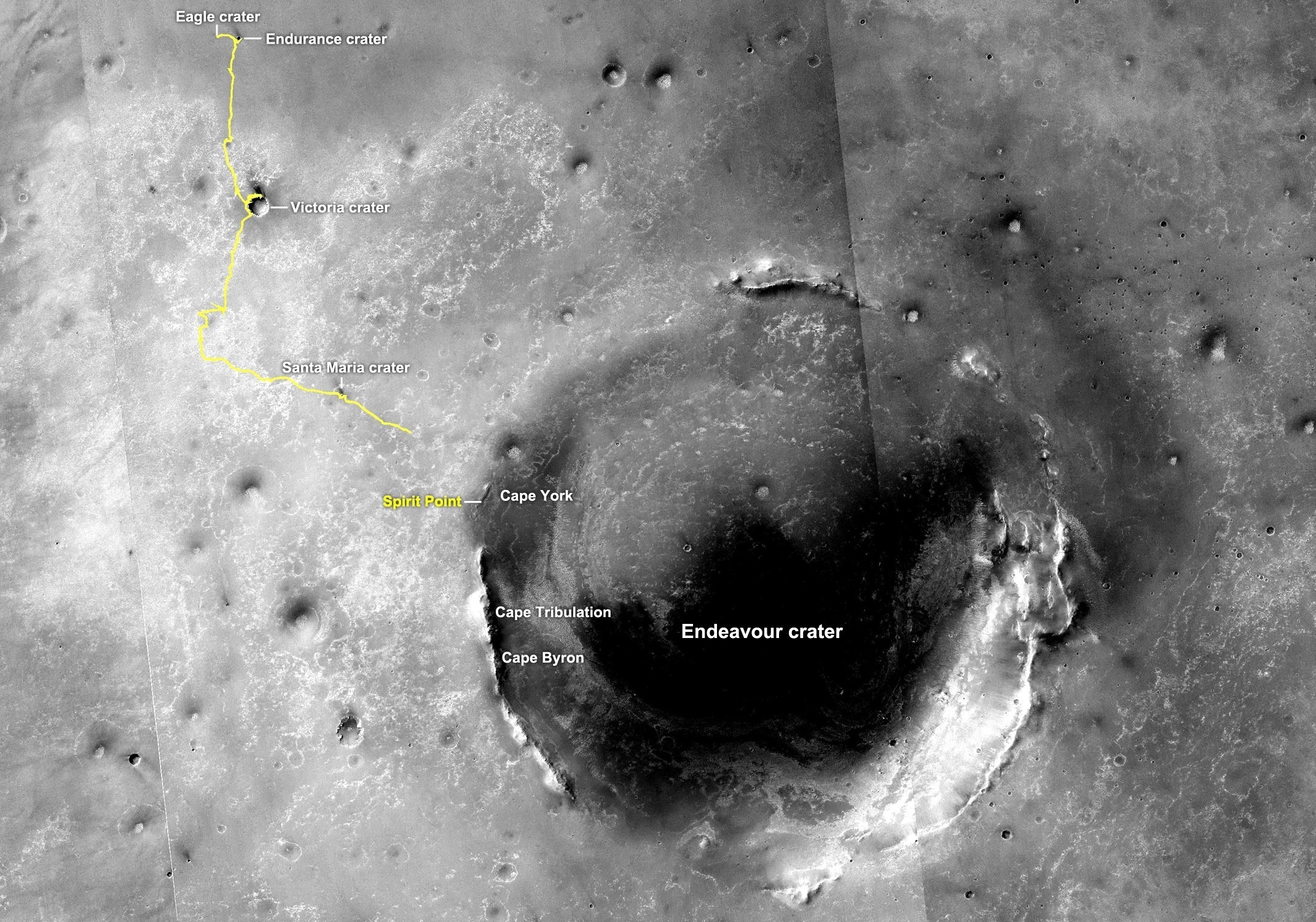
From Eagle to Endeavour
This image of Endeavour Crater was taken by the Malin Space Science Systems' Context Camera onboard the Mars Reconnaissance Orbiter (MRO). The yellow line on this map shows the route Opportunity took from Eagle Crater, where the robot field geologist landed in January 2004 (at the upper left end of the track) to a point about 3.5 kilometers (2.2 miles) away from the rim of Endeavour Crater. The rover arrived at the rim of 22-kilometer (14-mile) diameter hole in the ground in August 2011, after a three- year journey from Victoria Crater. The rover entered by way of Spirit Point, an area named after her twin "sister," which stopped communicating in March 2010.NASA /JPL-Caltech / MSSS
It was an impossible dream of a destination when the rover landed back in January 2004, but on August 9, 2011, Opportunity pulled up to the big crater's western rim through an area christened Spirit Point. It has been there working on the rim ever since.
Despite confronting a couple of operational issues this past month, "Opportunity is doing very well," reported JPL's Bill Nelson, chief of rover engineering.
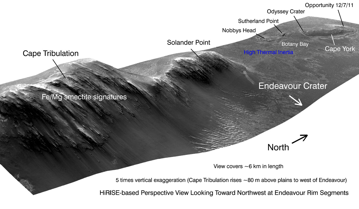
Since late last August, Opportunity has been exploring Matijevic Hill, a slight, 3-meter rise along the inboard edge of the Cape York segment of Endeavour's rim, which overlooks the deep bowl. The mission began, for all intents and purposes, anew. "Reaching Endeavour really has given us the equivalent of a second landing site for Opportunity," said Squyres.
Following the ground-truthing last December of the clay minerals - first detected several years ago by an infrared spectrometer known as CRISM onboard the Mars Reconnaissance Orbiter (MRO) and the scientific brass ring the rover came to Endeavour to grab - Opportunity put in a highly productive first month of the New Year and looks to have found more evidence for water that was likely more neutral to alkaline and thus much more hospitable to life and the formation of life.
When 2013 rang in, the rover was at a distinctive, bench-like outcrop called Copper Cliff conducting a series of in-situ or close-up science investigations on an area the team called Vermilion. It was finishing up its examination of sections just off-set from each other, using its Microscopic Imager (MI) and its alpha particle X-ray spectrometer (APXS), to collect data the scientists will use to determine its texture, geologic context, and chemical composition. Opportunity's mineral detecting instruments are no longer working, so the scientists are relegated to inferring many of their hypotheses.
After finishing its APXS integration of Vermilion Cliffs 2 on its Sol 3179-3181 (January 2-4, 2013), Opportunity departed Copper Cliff and drove approximately 13 meters (43 feet) toward the original Whitewater Lake rock it investigated back in September to further analyze up close the light-toned veins that run through the bedrock.
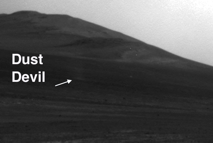
A dusty, devilish first at Endeavour
Jim Rich, MER co-investigator, of NASA Goddard Space Flight Center, initially noticed "a slightly lighter vertical shaft" in the Navcam above, in the upper left hand corner, in the area just below the hill. He routinely goes over every image line by line but this time he had a hunch. It paid off. Opportunity had caught a passing dust devil with her front hazard camera. This is the rover's first "captured" dust devil at Endeavour Crater and only the rover's second in the entire mission.NASA / JPL-Caltech
Here it is...
This image shows the section of the above image blown up, with an arrow pointing to the little devil, courtesy Jim Rice, who routinely examines all the rover's images, including the Navcams, Pancams, and MIs, in addition to the Hazcams. He since suggested that the rover go on dust devil watch once in a while. But so far none of the little devils have been observed other than the one the rover and then Rice spotted on Sol 3182 (Jan. 5, 2013).NASA / JPL-Caltech / labeled by J. Rice
Although there are lots of Whitewater Lake rocks around the rover, the science team decided to have Opportunity return to the original Whitewater Lake rock because they had studied that rock. "What we were after by going back is the portion of the outcrop that had varying concentrations of these small white veins to put the APXS down on, to kind of back-out their composition," said Arvidson.
As it drove to Whitewater Lake on Sol 3182 (January 5, 2013) Opportunity spotted a dust devil in the images, but no one would know until Jim Rice, MER co-investigator, of NASA Goddard Space Flight Center, analyzed the data.
"I initially noticed a slightly lighter vertical shaft that caught my eye in the Navcam," said Rice. "In the original version, it was pretty tough to see, but I examine all of our images - Hazcams, MIs, Navcams, and Pancams - from the rovers very carefully, and scan over them, line by line," he added.
When Rice zoomed in that lighter vertical shaft, his hunch was confirmed. "It was a dust devil," he said.
"We really don't see many dust devils at Meridiani, so it's a pretty rare event," said Squyres. In fact, while Spirit captured a good number of dust devils with her cameras, this is only the second dust devil Opportunity has seen and the first one seen at Endeavour Crater. As a result, the rover would be assigned to dust devil watch later in the month.
The following sol, 3183 (January 6, 2013), Opportunity had a brief bout of "amnesia," similar, the MER ops team thinks, to the bouts Spirit suffered in 2009. The engineers immediately zeroed in on corruption in the Flash file system, used by the rover for non-volatile telemetry storage, as the probable cause. "We suspect there is a sector that controls a block that is becoming corrupted," confirmed Callas.
Interestingly, when they looked back through the record, the MER ops engineers found that there have been four amnesia events over a 100-sol period, on Sols 3082 (September 24, 2012), 3161 (December 15, 2012), 3178 (January 1, 2013), and 3183, and none since then, Callas informed. "We didn't notice at first because they were relatively benign and they all happened lat at night when the rover wakes up to turn off the APXS and [effectively shut down to] go into Deep Sleep, or what we call mini-DeepSleep, because it doesn't DeepSleep all night, just half the night," he elaborated.
Although Opportunity's amnesia events can cause a loss of some data, they are not a health and safety concern, Callas said. The good news is it can be fixed. The bad news is: Not now.
"The fix is to reformat the Flash and that's what we did on Spirit, but the problem is it's intermittent," added Nelson. "So, if at the time you do the reformatting that troublesome sector is working just fine, then even after reformatting it will continue to fail because the software didn't read it as bad," he explained.
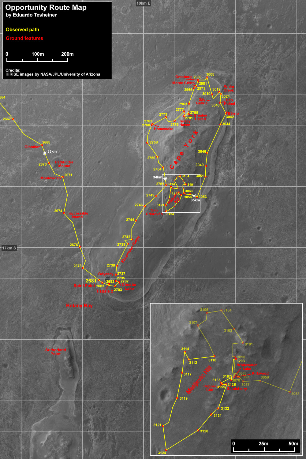
Opportunity route around Cape York
This route map shows Opportunity's travels up to its Sol 3135 (Nov. 17, 2012), and the rover's approximate current location on Matijevich Hill, a rise on the inboard side of the Cape York segment of Endeavour Crater's western rim. This image was produced by Eduardo Tesheiner, of UnmannedSpaceflight.com, who created it from images taken by cameras onboard the Mars Reconnaissance Orbiter.NASA / JPL / UA / E. Tesheiner
Meanwhile, the engineers also decided they would send a command to instruct the rover's Flash to use a separate bit of non-volatile memory called EEPROM (Electrically Erasable Programmable Read-Only Memory) to flag these events - since the rover doesn't remember them happening.
Opportunity spent a Martin day taking care of routine tasks, like taking the Tau, measurement of atmospheric opacity, and re-charging on Sol 3184 before driving into the second week of the month.
On Sol 3185 (January 8, 2013), Opportunity logged a short 2.6-meter (8.5-foot) drive to get closer to the intended light-toned vein targets on the original Whitewater Lake rock. Two sols later, the rover bumped a little more than 1 meter to position itself before the vein targets in the area of the flat, light-toned bedrock the team dubbed Ortiz.
Two sols later, 3189 (January 12, 2013), Opportunity was busily gathering data on the veins in this area where varying concentrations appear, taking the requisite series of pictures with her MI for a mosaic and APXS integrations to determine the chemical composition. Just as the rover had done at Vermilion on Copper Cliff, it began a series of measurements on Whitewater Lake's Ortiz area, in sections just off-set from one another.
That same sol, the MER team implemented the detection diagnostic command for the rover's Flash file system to flag the occurrence of any future amnesia events. "This is like the character with amnesia in a Hollywood movie writing notes to himself," said Callas.
From here on out, when the engineers see a flag in EEPROM they will know what to do to retrieve the data. "The late-night wake-ups to turn off the APXS are the only ones we've seen the amnesia events on to date," Nelson said, "and we have a way of working around it for the time being." Essentially, the workaround involves downloading the data from the APXS instrument, which also stores the data it collects, before that instrument is used again. "That will protect our APXS data, which is about the only thing that we're doing on these late-night wake-ups," he said.
Opportunity has been fine since though. No amnesia events have occurred since Sol 3183 (January 6, 2013), "and the rover remains in good health," assured Callas.
Opportunity continued her in-depth examination of the tiny white veins on Whitewater Lake throughout the middle of January, collecting the pictures for MI mosaics and APXS data on sections labeled Ortiz2, Ortiz3, and Ortiz2-b.
"We made a number of measurements in four places on this place on Whitewater Lake we call Ortiz, places of high concentrations of veins and low concentrations of veins with the APXS, all of it supported with MI images to show what the concentration of veins was, so we knew what we were looking at with the APXS," Squyres explained.
Kirkwood - Whitewater Lake
Opportunity took the images for this rich photograph of her September 2012 worksites. In the middle of the picture, you can see a part of the layered, sinuous-shaped outcrop the team dubbed Kirkwood. Just behind it, in the top part of the image is the fainter, circular, "slabby" flatter rock called Whitewater Lake, which the MER scientists concluded is part of a larger unit and the bearer of the phyllosilicate or smectite clay mineral signature detected by the Compact Reconnaissance Imaging Spectrometer for Mars (CRISM) onboard the Mars Reconnaissance Orbiter.NASA / JPL-Caltech / Cornell / ASU / S. Atkinson
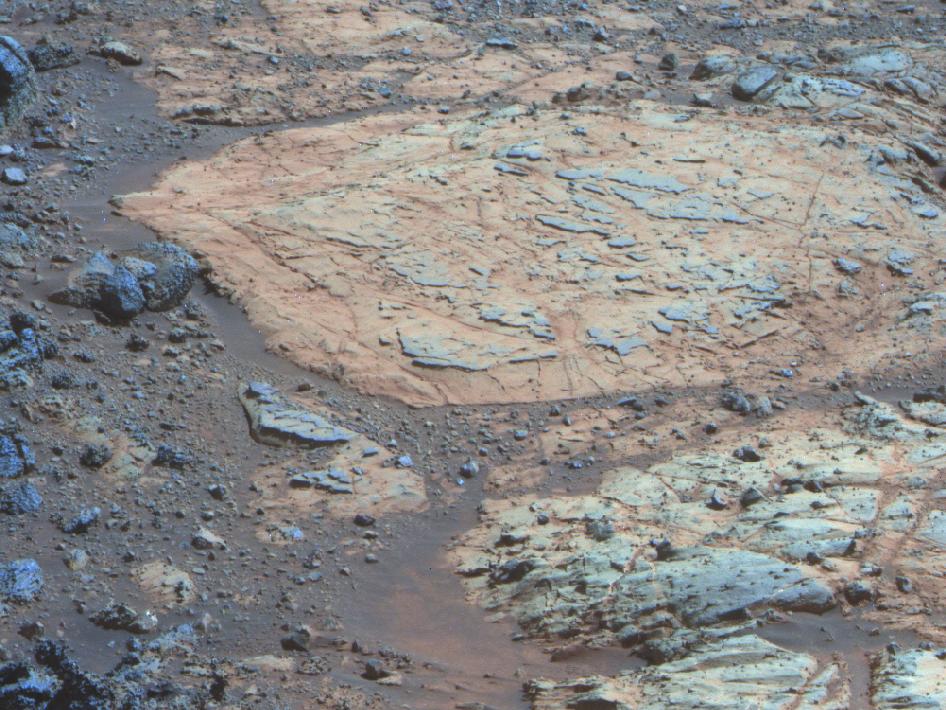
The original Whitewater Lake
Whitewater Lake is the large flat rock in the top half of the image. From left to right it is 0.8 meter (about 30 inches) across. The dark blue nubby rock to the lower left is Kirkwood, which bears non-hematite mystery spherules Steve Squyres dubbed newberries. The rocks to the lower right look like breccias, a type of rock containing jumbled fragments cemented together. They resemble other rocks in the area classed as the Shoemaker formation, hypothesized to hold deposits of material ejected when an impact excavated Endeavour Crater billions of years ago.NASA / JPL / Cornell / ASU
The robot field geologist also kept close camera "eye" on the Tau, which hovered around a hazy 1.0 all month, and on Sol 3194, it took two Taus, one with the Navcam and one with the Pancam, so the engineers and scientists could get an idea of how much dust was on the optics of the instruments.
"When the Tau goes up, you get more atmospheric heating because dust is absorbing the sunlight so the atmosphere gets warmer and so when it's warmer, you have more energy to drive wind events," explained Callas. "It's not surprising that you would have some wind gusts associated with elevated Tau because the atmosphere is warmer. That may then, in turn, lead to cleaning off the arrays."
And that's what happened, just before the New Year began, and again on Sol 3195 (January 18, 2013). Both dust-gusters cleared some of the accumulated coating on Opportunity's solar arrays, enabling the rover to slightly increase its energy production to around 540 watt-hours, more than half its full capability. "It's moving in the right direction," Callas said.
At the same time however, the Tau or amount of dust in the atmosphere that is rising will eventually rain back down. It's a cycle - up and down. "It's kind of like trying to clean your house with a leaf blower instead of a vacuum cleaner," said Callas. "All the stuff gets blown into the air and comes back down redistributed."
The question then becomes how much will land on Opportunity's solar arrays and how long will it be before the Martian winds blow it off again. For now, all is okay. "We're getting to the time of year when the atmospheric opacity is changeable," said Squyres. "The Tau values start to jump around this time of year. We hope they don't jump too high. We've seen this before, and a Tau of 1 is okay. We're doing okay with that. We'll continue to get regular weather reports and if there's a storm coming we usually get advance notice."
While Opportunity worked in a dust devil watch on Sol 3196 (January 19, 2013) along with the other routine tasks and the white vein study, the rover didn't capture any of "the little devils," reported Rice.
On Sol 3197 (January 20, 2013), Opportunity was preparing to brush the vein surface target with her Rock Abrasion Tool (RAT), when another stall in the Joint 2 elevation shoulder joint of her instrument deployment device (IDD) or robotic arm occurred. "It's similar to the stalls we've had before with this joint," said Callas.
And, as with the other stalls, this one happened during a very slow upward movement of the arm. The leading theory remains the same: with such slow motion of the arm against gravity, the joint motor does not have sufficient momentum to overcome the magnetic detents within the joint actuator. "That's because the IDD also has low torque," said Nelson. "The rotor is being caught by the magnetic detents. That's our leading theory. We're continuing to investigate this and we'll see where the investigation leads us."
"Because of the age of the rover, we are naturally concerned," added Callas. "But so far there is nothing that looks like there is any degradation."
While Opportunity continued her examination of Whitewater Lake's tiny veins, MER team members gathered on January 22nd and 23rd for its annual meeting at Caltech to discuss, among other things, how to finish the Matijevic Hill campaign, even as they were beginning to analyze the "excellent" data, as Arvidson defined it, that Opportunity returned from the Whitewater Lake veins to find the "big news" of the month.
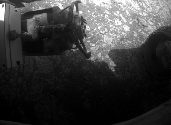
A good looking RAT
Opportunity took this picture of her Rock Abrasion Tool, affectionately known as the RAT on her Sol 3205 (Jan. 28, 2013). "The RAT bit still looks good," said Gale Paulsen, a systems engineer at Honeybee Robotics, which manufactured the instrument.NASA / JPL-Caltech
"What we see in the APXS data is the calcium and sulfur go up and down together," Squyres elaborated. "When you're on a lot of veins they go up and not a lot of veins they go down. The veins are calcium sulfate. Now calcium sulfate comes in different hydration states. So it could be gypsum and could be something else."
The best way for the MER scientists to determine whether or not these small veins are made up of gypsum is by looking at long wavelength Pancam filters for the sign of hydration in the near-infrared spectrum. "That's what we did at Homestake," said Squyres. And that's what they did at Ortiz.
"We've taken data, and just have not sent the result yet," Squyres said last Friday.
"If it is gypsum - I'm not saying it is because we're still analyzing the data - but [given that] we found what we think are gypsum veins out on the Bench, and now may be seeing them further uphill in the really ancient materials, would indicate this water environment was pretty extensive and led to a particular kind of mineral, calcium sulfate," said Arvidson. "And it would seem to be adding to the story in terms of repeated modification of the terrain by rising groundwater events."
If the veins do turn out to be gypsum and the water was extensive here, does that mean Opportunity is once again traversing the bed of what was once a sea or lake of some sort?
"We don't know yet, but personally I think it's more rising groundwater, because what's exposed at the surface today, because of erosion, was probably subsurface when this happened," Arvidson said. "I think it's telling us another piece of information about the history of aqueous deposition and the conditions that led to the formation of gypsum versus these polyhydrated sulfates like epsomite [a hydrous magnesium sulfate mineral] and the monohydrated sulfate like the mineral like kieserite, which are much higher up in the stratigraphic section" and which Opportunity found and studied earlier during its mission."
NASA / JPL-Caltech / Cornell / ASU / S. Atkinson
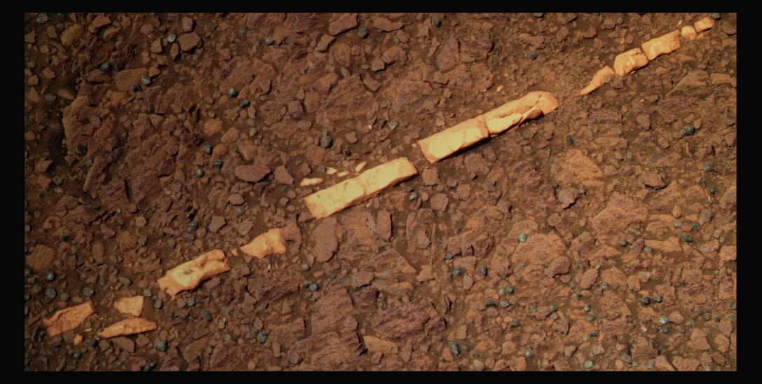
Homestake
This image of Homestake, which Opportunity took with her Pancam back in December 2011, was processed here by Stuart Atkinson. It shows the "sparkly bits" that Ray Arvidson, MER deputy principal investigator, talked about in past MER Updates. The scientists found that Homestake is rich with gypsum, a sure sign of past water in this area of Mars. Click here for more of Atkinson's work.So when Opportunity's 9th anniversary came along on January 24th, the rover was in the midst of inspecting the tiny white veins and returning another significant scientific water discovery. Despite the fact that the rover has now been operating on Mars 36 times longer than originally planned, the milestone came and went and the world barely seemed to notice or perhaps it was otherwise focused.
In part, that's because the Manti Te'o-Lennay Kekua / sweetheart-dies-of-cancer hoax was claiming every spare news minute and then some. In part, it's because the number '9' is "not one of those good round numbers," as several rover officials rationalized. And in part it's because the new baby on the Martian block, Curiosity, is now the media darling. But in the most objective sense, it's likely because working rovers on Mars just isn't so unusual anymore.
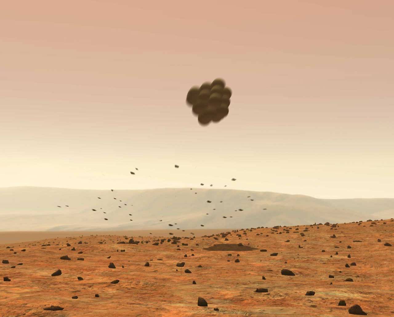
Bouncing on Mars
There were more than a few people who thought: You're kidding. But on Jan. 3, 2004, after Spirit bounced for what seemed an excruciating 16 minutes, Rob Manning, then the entry, descent and landing system manager for MER announced: "We're on Mars!"NASA / JPL-Caltech
Nine years ago, it was a different world. Facebook didn't exist. Neither did Twitter, social media, the iPad or the solar-powered, Waste Allocation Load Lifter - Earth class robot, known and loved as Wall-E. There were plenty of people, even at NASA centers, who snickered at the prospects of Spirit and Opportunity bouncing safely down on Mars, though they would likely not admit it now. Mars had come to be known as "the death planet" for spacecraft. Only 1 in 3 ever made it, and most of those were orbiters, not landers - and landing on Mars is another challenge altogether.
Moreover, for the first time in planetary exploration history, the public was invited along - with an almost all access backstage pass - via the Internet. "They are emissaries not just of NASA or the United States, but of the planet Earth," Squyres said then. Whatever was going to happen was going to happen in front of the entire world. To say the pressure was on MER would be an understatement.
As Spirit defied the odds and Mars, Earthlings around the world embraced the robot field geologist. Within 72 hours of its landing, more than one billion people from around the world jammed the NASA/JPL websites and their mirror sites, setting an Internet record. Without so much as one Tweet-up. Hundreds of millions more jumped online as the mission continued.
Twelve days after it's landing, Spirit rolled on the Martian surface, and put all six of its titanium wheels in the Martian dirt. "To this day the highest high of the entire mission was Sol 12 when we finally had a healthy rover on Mars with 6 wheels in the dirt," said Squyres. "That was the culmination of 16 years of my life, to get to that moment. That was and will I think remain the highest high."

Six wheels in the dirt
On Spirit's Sol 12, the rover rolled off its lander and put all six wheels into the Martian dirt for the first time. It was, for Steve Squyres, MER principal investigator, the moment. "To this day the highest high of the entire mission was Sol 12 when we finally had a healthy rover on Mars with 6 wheels in the dirt. Getting to that moment was the culmination of 16 years of my life." The picture above is one of the postcards Spirit sent home on Sol 12.NASA / JPL
Opportunity's magical expedition began with a landing no one in a gazillion years could have planned, scoring "the world's first 300-million-mile, interplanetary hole-in-one," as Squyres described it then. It had rolled to a landing right inside the backyard-sized Eagle Crater in the Meridiani Plains.
When Opportunity opened her "eyes," she was staring into the first bedrock seen on Mars, something that shook the bleary-eyed scientists and made more than a few journalists believe she had found remnants of a previous civilization. When the dust settled, the clues for past water were right there before her. For Arvidson, "landing in Eagle Crater in a hole-in-one with outcrop 5 meters away that formed in water environment " was the number one moment.
No one back in those halcyon days of rovers on Mars ever even in the wildest of dreams could imagine where Spirit and Opportunity would take the world. Back on January 25, 2004, Squyres was in "awe," as he put it. "I keep thinking this can't possibly get any better and it just does."
On hearing that bit of history 'replayed' now, Squyres can't help but laugh, and laugh some more. "I would have loved to have sat down with that guy - with 9 years ago me -and told him about Matijevic Hill. It'd be like: 'Dude, you better sit down. You're just not going to believe this,'" he chuckled.
Opportunity, the rover who loves to rove, meanwhile, has always just kept roving on. Of the twin, this one was "Little Miss Perfect," said Jake Matijevic years ago. As readers of the MER Update know well, Jake was systems engineer at JPL who was on the original rover design team, who had so much to do with Spirit and Opportunity becoming the rovers we know today, and for whom Matijevic Hill is named.
After one final 13-filter Pancam look at Ortiz on Sol 3203 (January 26, 2013) and a quick fine attitude, a procedure that reorients the rover's attitude, Opportunity left the Whitewater Lake outcrop and drove 21.5 meters (71 feet) to the north, heading for Flack Lake to investigate the small mystery spherules known as newberries.
Meridiani Planum in View
This image shows one of Opportunity's first breathtaking views of the Martian landscape after its hole-in-one landing at Meridiani Planum on Mars. On the left, the rover's mast can be seen in a stowed position. The rover landed at approximately 9:05 p.m. Pacific Standard Time Jan. 24, 2004. The over took this picture with its Navigation Camera (Navcam).NASA / JPL
On Sol 3205 (January 28, 2013), Opportunity performed a slight turn for communications to improve relay downlink and took some pictures of its Rock Abrasion Tool (RAT) bit to assess its condition. "The RAT bit still looks good," reported Gale Paulsen, a systems engineer with Honeybee Robotics and Spacecraft Mechanisms Corporation, which manufactured the instrument. "There was no noticeable wear from the last grind," he said.
Opportunity approached a newberry-rich part of Flack Lake, with a 4.8-meter (16-foot) bump to the west on Sol 3206 (January 29, 2013), and snapped took a Pancam picture of a target called Broken Hammer Junior.
"We are now going to do with the newberries what we did with the veins, make multiple measurements of variable concentrations to try and tease out their composition," said Squyrs. "We have driven over to a place where we are about to begin investigation we hope will tell us more about the composition of the newberries."
"The idea is to do multiple off-set observations from a high concentration to a low concentration, so we can see what the composition of the spherules, newberries, is relative to the matrix that's holding them," added Arvidson.
On the next sol, 3207, the robot field geologist took pictures for an MI mosaic on a section dubbed Fullerton1, and followed it, as usual, with an overnight APXS placement.
As January turned to February, Opportunity was looking good and operating as well as possibly could be expected. No "amnesia" events with the Flash file system have occurred since Sol 3183, and the rover is producing upwards of 530 watt-hours of power, plenty to keep it driving and working.
Checking out Flack Lake
During the last week in January 2013, Opportunity roved over to an area the MER team dubbed Flack Lake to begin a series of studies on the mystery spherules, now known as newberries, which she found on arriving at Matijevic Hill. The rover took this image with her panoramic camera (Pancam) on her Sol 3206 (Jan. 29, 2013).NASA / JPL-Caltech / Cornell / ASU
Since landing in 2004, Opportunity had driven a total of 35.48 kilometers (22.05 miles), putting it within about 420 meters of the Apollo 17 Moon buggy record of 35.90 kilometers (22.30 miles). Then, the MER will be within reach of the champion Lunokhod 2, the Russian Moon rover that logged slightly more than 37 kilometers (about 23 miles) of terrain in about four months. Still, to be fair, the top 1 and 2 rover distance records are held by Moon rovers, one, Apollo 17, piloted by a human inside it; the other, Lunokhod 2, an unmanned rover and Opportunity has been roving on Mars, a much more dangerous planet for a rover of any kind.
Although many people seemed to miss the wonder of Opportunity's 9th anniversary, the rover is now firmly rooted in space science history and contemporary pop culture, which may well be part of the reason rovers on Mars don't seem so unusual now. Beyond the numerous awards earned by the rovers and the MER team over the years, asteroid 37452 was renamed Spirit years ago. And, just this past month, Opportunity, ostensibly, was roving across television screens coast to coast in the U.S., starring in a series of General Electric commercials, from its current "brilliant machines" advertising campaign. Actually, the rover's image was roving across television screens, while the real deal was up on Mars working away and wondering why the commercial creators used a masculine voice to speak for her.
In coming sols, once Opportunity completes its study of the spherules - "which will take a while," said Arvidson - the rover may then be directed to go in search of that main contact or boundary line between the older Kirkwood/Whitewater Lake/ Copper Cliff bedrock and what the scientists believe is the overlying Shoemaker Formation. "We don't know exactly where the contact is other than it's gotta be uphill," said Arvidson.
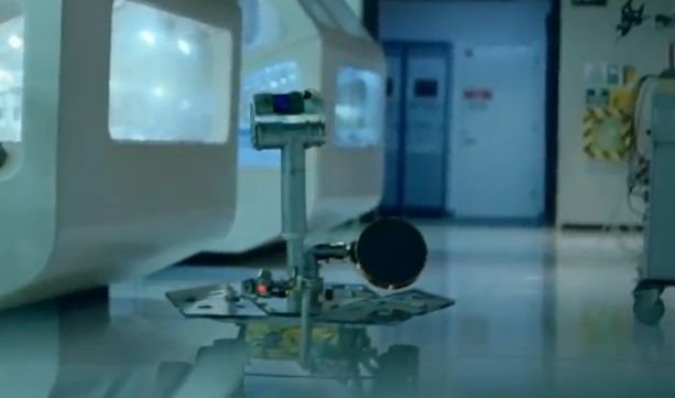
Star of Mars stage and Earth screen
Opportunity, ostensibly, can be seen roving through a couple of the new series of General Electric commercials, part of the corporate giant's latest "Brilliant Machines" advertising campaign. This is a "screen grab" from one of them. Although Opportunity "speaks" in a distinctly male voice - and the MERs were deemed in the beginning to be of the feminine persuasion - the commercials have created a buzz among robot geeks on the Internet for their entertainment value.General Electric
Going on the hunt for the major contact or boundary depends on how long the newberry campaign takes, said Squyres. "We've looked for one and haven't seen it yet. The problem with a hunt like that is that it's open ended. You can spend a lot of time looking and not finding it. And we need to get moving. We have to make some decisions about what else we're going to do after we finish up the newberry campaign, and those decisions have not been made yet."
Even as Opportunity is wheel deep in its textbook-writing studies on Matijevic Hill, Solander Point is beckoning. There is a "growing interest" in getting the rover on the road south, Arvidson acknowledged. "We may make a couple more measurements, but we are beginning to wrap up the Matijevich Hill campaign."
Of course, Arvidson added, as Squyres has before said: "There's always the possibility that we could find something in what we're doing during our wrap-up that could lead us to stay and wind up at Greeley Haven for next winter."
But one doesn't get the feeling that's likely. Matijevic Hill, which is titled toward the bowl of Endeavour, is only about 3 meters high. "The exposure is interesting, but limited," said Arvidson. Plus, Solander Point would be an ideal place for Opportunity to winter.
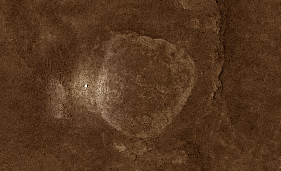
Endeavour Crater's west rim
There is "a growing interest" in getting Opportunity back on the road, said Ray Arvidson, MER deputy principal investigator, in late January. The team has already selected Solander Point as the ideal place for the rover to spend the next Martian winter, which can be seen here to the south of its current location. This graphic was put together with an image taken by the HiRISE camera onboard MRO.NASA / JPL-Caltech / University of Arizona
"It has beautiful, beautiful slopes," noted Arvidson. "There are meters and meters of stratigraphic section there, a much thicker stratigraphic section of this ancient Noachian crust. And the cool thing is that it's all tilted north. So we can have a great time crawling around on the northerly slope and not be immobile for the winter."
In addition, the trek across Botany Bay promises more scientific treasures on the way to Solander Point. "There are large exposures gypsum we think, based on CRISM data, not as veins but as bedrock," said Arvidson, who is also a co-investigator on the MRO spectrometer. "So we may be driving across Botany Bay to find the lowest part of the Burns Formation exposed."
As the MER Update goes into production for posting, the rover team is considering its options. "We have to make some smart decisions about what our priorities are," said Squyres. "We want to get to Solander Point before winter and do that with enough safety margin. It's a long drive to get down there, and we'll want to do science on the way too."
"It's been a great run," said Callas. "Opportunity is in great health, especially for its age, and I'm looking forward to the 10th anniversary." Although always optimistic, Squyres remained cautious and tempered on the subject. "Solander Point is 2 kilometers away and nothing is promised after 9 years on a 90-sol mission," he said. "Every day is a gift." Nevertheless, Opportunity's future looks bright and preparations are already being made for next January's big 10th anniversary. The National Air & Space Museum on the Smithsonian Mall, for one, is working on an exhibition that will be on display for six months, and there are other murmurings blowing in the wind. Stay tuned.

Remembering Spirit
This poemster was written by Stuart Atkinson (words) and illustrated by Glen Nagle, both of UMSF.com. The images are courtesy NASA / JPL-Caltech / Cornell.Let’s Go Beyond The Horizon
Every success in space exploration is the result of the community of space enthusiasts, like you, who believe it is important. You can help usher in the next great era of space exploration with your gift today.
Donate Today