
 Explore Worlds
 Find Life
 Defend Earth


A.J.S. Rayl • May 03, 2012
Mars Exploration Rovers Update: Opportunity Begins to Wrap Winter Science, Mission Celebrates Month 100
As winter began to retreat in the southern hemisphere of the Red Planet, Opportunity was commanded to finish up her science assignments in April in preparation for leaving its refuge, and the Mars Exploration Rover (MER) mission rolled through its 100th month of exploration.
One hundred months Opportunity has been driving around Meridiani Planum, Mars. That’s 97 months beyond its three-month primary mission. Wow.
Mars Exploration Rover
NASA / JPL-Caltech / Maas Digital
On Mars, mere survival would be a huge accomplishment, but this rover has turned its first 100 months into an adventure story with all the right stuff to warrant a banner headline of acknowledgement. From bouncing to a landing inside a crater making “the world’s first 300 million mile hole-in-one,” as Steve Squyres, principal investigator described it, and then opening her eyes to find the evidence for past water it had come looking for, Opportunity drove on to become the first robot to inspect its own jettisoned heat shield, the first to find meteorites on Mars, the first drive into a crater, the first robot to be caught by and escape the grip of a life-threatening sand dune, the first to survive the eye of a global dust storm, and so much more.
Yet, there were no bells or whistles or fanfare for this ‘100’ milestone, like there was for say The Simpsons’ 100th episode or any number of other ‘100’ achievements. No notice or press release from NASA, and no Tweet went viral.
In fact, MER’s 100-month milestone went all but unnoticed even by team members who continue to work with Opportunity every day, and whose responsibilities have only intensified because the mission has endured beyond all expectation and so many of the MER crew are now doing double-duty on other missions, including Mars Science Laboratory, which is to deliver Curiosity, the next-gen bigger, faster, stronger rover to Mars in August.
The MER team members interviewed who realized or were reminded of the MER mission’s 100-month milestone responded in kind: “Wow.”
One hundred months of roving Mars. It is a milestone to be sure. But there is just no time to stop, no purpose to resting even for a minute on past laurels. There’s a big crater and an ancient Martian world to uncover, and more science ‘gold’ gleaming in the rim, and everyone is ready to rove on.
NASA/JPL-Caltech/Cornell/ASU
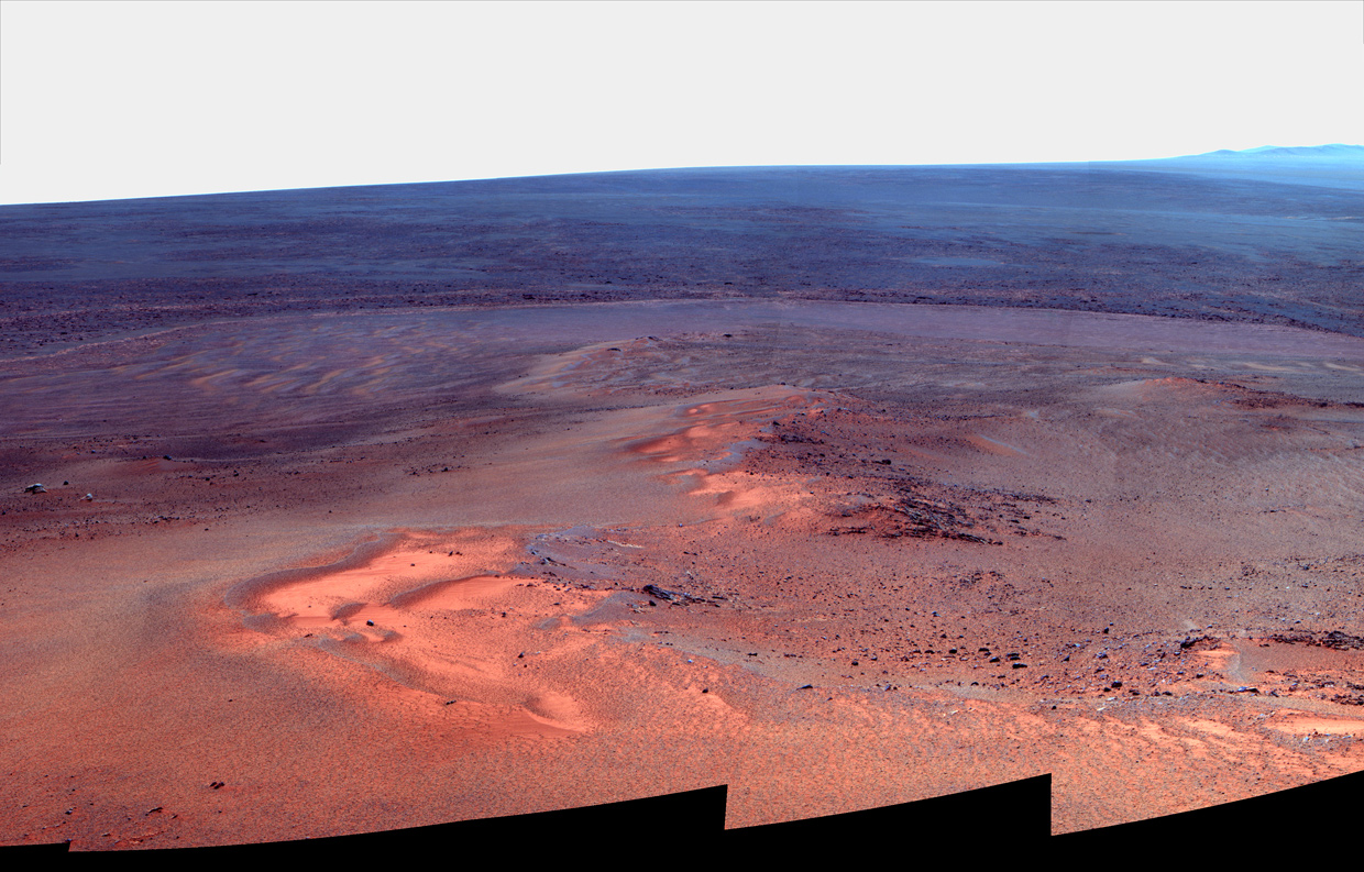
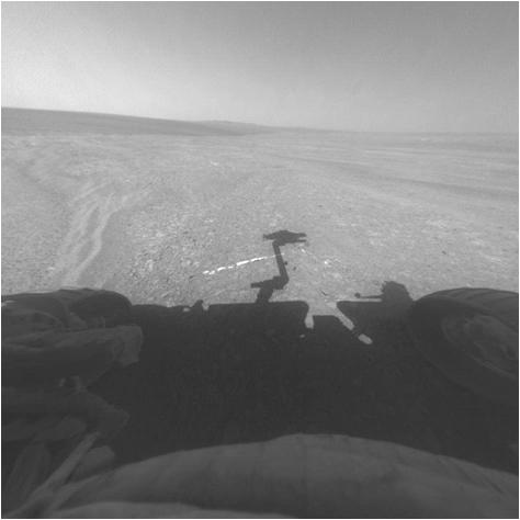
The View from Greeley Haven
The rover took the pictures for this false color mosaic in mid-January 2012 with its Panoramic Camera (Pancam). The picture shows the windswept vista northward (left) to northeastward (right) from Opportunity's parked position. The rover hunkered down for its fifth Martian winter on a gentle slope on an outcrop named Greeley Haven, in honor of Ron Greeley, MER science team member and professor at ASU, who passed away unexpectedly last October. The view, which is part of the Greeley Panorama under construction now, includes sand ripples and other wind-sculpted features in the foreground and mid-field. The northern edge of the Cape York segment of the rim of Endeavour Crater forms an arc across the upper half of the scene.Opportunity pulled into Greeley Haven in January of this year and has been parked there since, working and waiting out its fifth Martian winter. Located on the northern end of Shoemaker Ridge, the bedrock "spine" that defines Cape York on the rim of the 22-kilometer (14-mile) diameter Endeavour Crater, the haven offered Opportunity a gentle, 15-degree northern slope where it could angle the solar arrays to soak up as much of the winter Sun as possible. It was named in honor of Ron Greeley, of Arizona State University (ASU), a MER science team member and much loved planetary scientist and mentor, who passed away unexpectedly last October.

NASA/JPL-Caltech/M. Howard
Simulated image of Opportunity parked at Greeley Haven
Michael Howard, the creative force behind the Midnight Mars Browser software put together this simulated image showing Opportunity's approximate position and orientation at Greeley Haven. The rover pulled into this winter refuge in January and has been working here ever since.Despite the brutally cold temperatures, this is the first time Opportunity has had to park for the winter, unlike her twin. Spirit, which landed a little further south of the Martian equator on the other side of the planet, had to park and cling to life every Martian winter, and it was the last Martian winter that took Spirit’s life.
The MER team had been cautiously confident from the outset that Opportunity would be able to work through this, its fifth, harsh winter. Once again, the rover showed her legendary MER mettle. "It was a month of staying the course and finishing up measurements," reported Ray Arvidson, deputy principal investigator of Washington University St. Louis, who is overseeing the winter science campaign.
It will still be a while before spring takes full command at Meridiani Planum, but "winter is in our rear view mirror," announced John Callas, MER project manager at the Jet Propulsion Laboratory (JPL), the NASA center the rovers call home.
Winter solstice had just passed when April dawned on Meridiani Planum, and perhaps by way of celebration, Mars whipped up a few small gusts of wind to clear some of the thick coating of dust from the rover's the solar arrays. Multiple dust gusters throughout the month would help Opportunity energetically bid adieu to the season, enabling the rover to not only metaphorically shake off winter, but be empowered to labor on. And work the robot field geologist did, devoting the most of the past month to completing its winter science assignments.
"The dust cleaning events are one of the nice pieces of news this past month," said Bill Nelson, chief of the rover engineering team at JPL. "There is a little bit of a lag after winter solstice before external temperatures start to come up, so we should begin to see some [temperature] increases in May. Even so, with the dust cleanings, the rover's energy level is looking very good right now."
With Martian spring right around the corner and the rover’s power levels rising, the prospects for Opportunity's continued exploration look as bright ever almost. The rover is a centenarian [in rover years] after all. Still, this robot field geologist remains in "as good of health as one might expect," said Nelson, "and not confronting any new issues."
The issues that popped up in March – a sudden stall in the rover's robotic arm when an instrument failed to achieve ground contact as programmed, and the subsequent discovery in follow-up images that the rover's left front wheel had moved downward by a few millimeters (1 centimeter or 0.39 inch) – were "resolved" early in April, Nelson said.
NASA/JPL-Caltech/S. Atkinson.
Opportunity's wheel drop
This animation, courtesy of Stuart Atkinson, shows the movement of Opportunity's left front wheel. This apparent "settling" occurred sometime between the rover's Sols 2894 and Sol 2899 (Mar. 15 and 20, 2012). As it turned out, it was "a terrain-interaction" issue, according to chief rover engineer Bill Nelson, of JPL, and the rover was and remains "just fine.""We routinely check for motion," Nelson informed. "We don't usually expect it, but we always check, and when motion is detected, we investigate, even if it's only a few millimeters."
So, even though nothing appeared to be operationally wrong with Opportunity's arm and the left front wheel appeared to have settled just a few millimeters, a group of the team's engineers went to work immediately investigating the stall and the "wheel drop." The rover was ordered to continue the work it could do without using her arm.
Before the end of the first week of April, after a week and a half of diagnostic testing, the rover engineers determined that both events were basically caused by "terrain-interaction” issues. "These anomalies had nothing to do with anything going wrong with Opportunity," Nelson said. “The rover is fine and is stable.”
The very next sol or Martian day, Opportunity was back to using her arm and working full steam ahead to make up for lost time on the close-up examination of the bedrock on which it is parked. Talk among team members, meanwhile, turned to roving on.
Engineers and scientists alike are now eager, anxious even to get the rover back on the road. There are tentative plans to have Opportunity "bump" or turn and move a short distance to 'open up' its foreground workspace and add to the winter's close-up imaging study of the bedrock that forms Greeley Haven and the northern end of Shoemaker Ridge. Still, Callas confirmed the team is "getting close to wrapping this campaign up.”
NASA/JPL-Caltech/Cornell/ASU
Me and my shadow
Opportunity used the Pancam to snap this image during the late afternoon on her Sol 2888 (Mar. 9, 2012). Some of the pictures that the rover has acquired during rare late afternoon photo sessions have been likened to the black and white photography of the renowned photographer Ansel AdamsOpportunity focused on three primary studies during the winter science campaign: 1) radio science, a study that will allow scientists to better deduce the make-up of Mars' core, and which actually required that the rover remain stationary; 2) a full-scene, 360-degree, color panorama of the rover's surroundings, also aided by the rover's extended stay in its winter haven; and 3) an exhaustive study of the bedrock on which it is parked, which is the northern end of Shoemaker Ridge at Cape York, to determine its composition and glean as much as possible about the geologic history of the Endeavour Crater area.
Now, as April turns to May, as winter gives way to spring, Opportunity has achieved its main science objectives at Greeley Haven, and then some. Although, it has not yet returned any big new discovery or surprises from its work this winter and may not, the rover has packed in a lot of solid scientific research destined to enrich planetary science textbooks.
In analyzing data as it comes in, the MER scientists are confident that Greeley Haven, for example, is pretty much exactly what they expected it to be, according to Arvidson. "It's similar to other outcrops we've seen on Cape York and is definitely impact breccia that's been all jumbled up," he said. "All of Cape York seems to be held up by these impact breccias, which is not surprising, because it's the rim of a huge crater."
The Greeley Panorama, essentially done and downlinked, is in "post," as they would say in Hollywood. "It is now being very laboriously calibrated and map projected," confirmed Planetary Society President Jim Bell, of ASU, the lead scientist for the stereo panoramic cameras (Pancams) onboard the MERs.
The first real look at the lushest, most detailed panorama of a Martian landscape that the mission has produced to date may be presented to the world in a couple of weeks, Bell said. "It's going to take a while, because we took a bunch of special calibration measurements before starting to characterize all the dust on the lenses" [deposited during the global dust storm of June 2007]. "It will take some time to slog through it all and we're working on it,” he explained. More than that, this one is personal. "Ron was a colleague and friend of mine, and I want to spend the extra time to make this really beautiful,” Bell added.

NASA/JPL-Caltech/D. Bouic
Opportunity Adams
Near sunset on sol 2847 (Jan. 27, 2012), Opportunity gazed to the east-southeast and the distant line of peaks that mark the far rim of Endeavour Crater, capturing this scene reminiscent of the American west photography of Ansel Adams. UMSF.com member Damien Bouic rendered it here in glorious Martian color. The setting Sun throws very long shadows from the low-standing ridge that the rover, is in turn, standing on. In fact, Opportunity's shadow is visible, a small, blurry speck standing on the ridge's shadow.The radio science research – Opportunity's prime directive this winter – could really only be completed with the rover in a more or less stationary position for an extended period of time. The team had plans for Spirit to do the study after the last Martian winter, but that was not to be.
This winter, everything came together for Opportunity to take on the research. Two to three times a week for the last four months, the rover has regularly turned its high gain antenna (HGA) toward Earth and established a 2-way radio link with the Deep Space Network (DSN) radio telescopes, and then tracked the dynamics of Mars’ spin axis by recording Doppler shifts.
Opportunity will be moving on soon, but the four months of data it acquired have turned out to be "better than anticipated," according to the study's principal investigator, Bill Folkner, of JPL. Once the data is all downlinked, he and his and team will scrutinize the Doppler shifts and then back-calculate the planet’s interior density as a function of the depth needed to produce the spin axis dynamics.
Late last month, Folkner reported that he had run the simulations to determine that he would have enough data by the end of March to improve the estimate of the precession rate of Mars by a factor of two. That new precession rate will effectively throw out about half of the Mars interior models considered reasonable before Opportunity's efforts, he noted, and add to planetary science knowledge. The rover's continued radio science work in April now gives Folkner enough additional data to test for systematic errors in the work.
Beyond the radio science, the Greeley Pan, and the up-close examination of the local bedrock, Opportunity also sent home a few unexpected little gifts for Earthlings this winter – a collection of landscape pictures taken several times over the course of the season in the low light of late Martian afternoons. While the rover has taken these images in color and using all 13 filters of its stereo Pancam, they are hauntingly reminiscent of the black and white landscapes of the American west taken by environmentalist-photographer Ansel Adams.
NASA/JPL-Caltech/MSSS
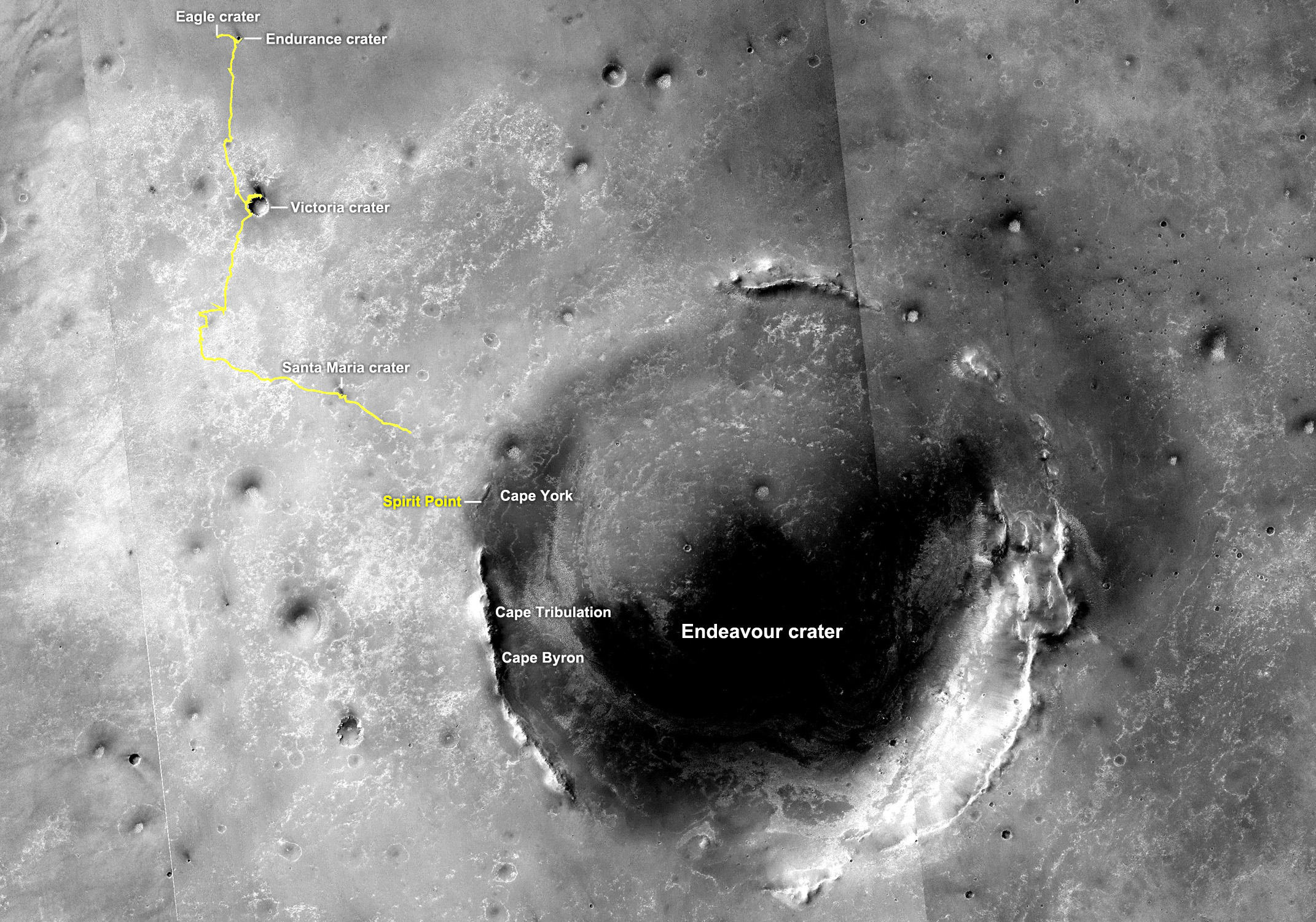
Path to Endeavour Crater
The yellow line on this map shows the course Opportunity charted from the place where it landed in January 2004, inside Eagle Crater, at the upper left end of the track, to a point about 3.5 kilometers (2.2 miles) away from the rim of Endeavour Crater."There's some fun science in these low light images that you can't do when the Sun is high in the sky, or can't do as well – you can see, for example, great textural information," Bell pointed out. “So, the folks on the team studying dunes and ripples are really interested scientifically in these low light images, because they can get an enormous amount of detail in the undulating landscapes we're looking at around us," he said.
Opportunity Adams hasn’t been able to pull out her stereo Pancam to take these late afternoon shots very often. “It's been a relatively rare opportunity," Bell noted. In fact, the rover has only had the chance to take these images three times, on Sols 2840 (January 19, 2012), 2847 (January 26, 2012), and 2888 (March 9, 2012). "But people have been watching for that opportunity and the rover engineers have been very supportive of that as well," he said.
It's easy to see why. The photographs are stunning. As much science as the images may boast, when viewed simply as postcards from Mars, they beg to be accompanied by the words: 'Wish you were here.'
For some explorers or would-be explorers or just interested human beings looking at an alien, distant planet, these images pack an emotional, deeply humbling wallop that words could never adequately describe.
"From our perch on Greeley Haven, looking out onto the plains from where we drove up along the crater rim, with the Sun at our back and the shadows of the rovers in front of us –," Bell began by way of description – "well, some of these views are spectacular.”
They would have to be to draw comparison to a heralded artist like Ansel Adams. "No one person, however, is responsible for these pictures,” Bell said. “An enormous amount of time and energy go into these images. It's a huge team effort, and I'm lucky to be part of that big team."
Now, as the Martian breezes escort May to Meridiani Planum, Opportunity's work at Greeley Haven is winding down. For weeks now, the scuttlebutt among team members has been that Opportunity will rev her engines and rove onward sometime in June, as early as four to five weeks from now. "But that was based on the old assessment, before we had these dust-cleaning events," Callas noted. A MER ops team is currently working on a new assessment, he said, and "if power levels continue to improve, my expectation is we might move forward on that."
Theoretically then, Opportunity could be pulling out of Greeley Haven in as little as two weeks. Whether it's two weeks or six weeks, the rover will likely drive back to the Bench first, to find and study another gypsum vein, like the vein dubbed Homestake, which it found last December. Gypsum is a clear and present sign of past water, and the scientists have their hopes set on finding one bigger than Homestake, a vein they can clean off and really check out thoroughly by grinding into it.
NASA/JPL-Caltech
Approaching Homestake
This view from the front hazard-avoidance camera on Opportunity shows the shadow of the rover's arm falling near a bright mineral vein informally named Homestake, near the edge of the Cape York segment of the western rim of Endeavour Crater. The vein is Opportunity examined the vein, which is about the width of a thumb and about 18 inches (45 centimeters) long, last November. The science team found it to be rich in calcium and sulfur, possibly the calcium-sulfate mineral gypsum.As fate would have it, the science team's paper on Opportunity’s gypsum discovery at Homestake is slated to be published in the journal Science May 4th. For a science mission to Mars, is there any cooler to toast Month 100 of the Mars Exploration Rovers’ three-month tour?
Opportunity from Meridiani Planum
NASA/JPL-Caltech/UA
Orbital view of Greeley Haven
Greeley Haven is an outcrop near the northern tip of the Cape York segment of the western rim of Endeavour Crater. It provides a north-facing slope of 15 degrees or more to aid electric output from Opportunity's solar array. It also presents geological targets of interest for investigating during months of limited mobility while the rover stays on the slope. This image, covering an area about 2,000 feet (about 600 meters) wide, indicates the location of Greeley Haven on Cape York. The base image of the map is a portion of an image taken by the High Resolution Imaging Science Experiment (HiRISE) instrument on the Mars Reconnaissance Orbiter, on July 23, 2010.There was no April fooling this year, either on Mars and or on Earth, not to speak of anyway. Opportunity was busy working and the rover engineers were busy investigating the anomalies that occurred or were otherwise discovered on Sol 2899 (March 20, 2012).
It began when the IDD or robotic arm stalled when the rover attempted to place one of its instruments on the ground as commanded. Then, while viewing before-and-after images to figure out why that stall occurred, the rover ops team discovered a "downward movement" of Opportunity's left front wheel, a "wheel drop" as it was identified.
The wheel drop occurred, they determined, sometime between the rover's Sol 2895 and Sol 2899 (March 16 and March 20, 2012), but whether or not it had anything to do with the IDD stall, they had no idea. First things first.
The attending rover planners commanded Opportunity to re-orient herself and on Sol 2910 (March 31, 2012), she did. Using the technique the team calls a Quick Fine Attitude (QFA), the rover re-established her attitude by measuring her position in relationship to the Sun, and then taking a series of images with her Hazard camera (Hazcam) to describe exactly where she is, and specifically how she's positioned.
NASA/JPL-Caltech/UA
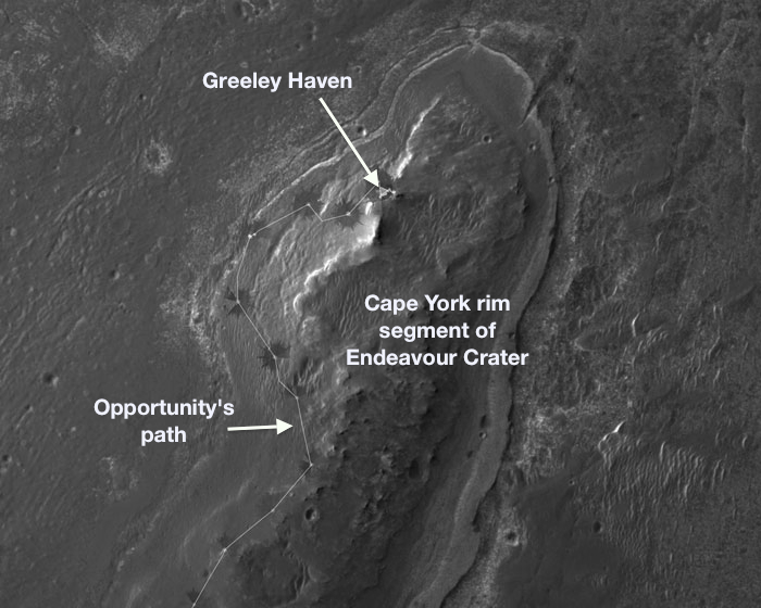
Cape York neighborhood
This image taken from orbit shows the path Opportunity drove in the weeks after arrival at the rim of Endeavour Crater. The sol number (number of Martian days since the rover landed on Mars) are indicated along the route, with Sol 2674 corresponding to August 2, 2011 and Sol 2688 corresponds to August 16, 2011. The rover officially drove into the rim area of the crater at a place called Spirit Point, on its Sol 2681 (August 9, 2011). The base image of the map is a portion of a picture taken by the High Resolution Imaging Science Experiment (HiRISE) instrument onboard the Mars Reconnaissance Orbiter on July 23, 2010.Comparing these new images to images collected just after the anomalous wheel drop, the engineers saw no more movement. Good news. Nevertheless, they decided to have the rover "stabilize" her left-front wheel in coming sols by spinning and wiggling it, movements that should kick out or compress any loose material under the wheel, as well as relax any tension in the rover's suspension.
On April 1st, just hours after the winter solstice passed (March 30, 2012), Mars whipped up a small wind gust that cleared a little more dust from Opportunity's solar arrays, bumping energy production from around 305 watt-hours to 321 watt-hours. You could almost hear the rover saying 'Life is good.'
"The dust-cleaning events have been small, but they keep adding up and it's going in the right direction," said Callas.
The skies over Endeavour Crater remained hazy though and Opportunity returned an atmospheric opacity or Tau of 0.521. Her solar array dust factor, however, the gauge by which the team determines how much of the photon fuel of the Sun the robot is able to actually convert to energy, is slowly but steadily getting better, moving to 0.506 at the top of April.
NASA/JPL-Caltech
Opportunity working Greeley 3D
Opportunity took this image with her Pancam, and MER poet Stuart Atkinson rendered it in 3D. For more of Atkinson's words and pictures, visit his Road to Endeavour blog.While the engineers continued investigating the March 20 anomalies, Opportunity was standing down from using her IDD. That gave her the chance to spend some additional quality time this past month to play tourist again, to pull out her Pancam and snap away, recording the views of the Martian landscape that she was drinking in, near and far. "We've been taking a big 13-filter mosaic of the foreground around us on the assumption that we'll probably be driving sometime within maybe a month or so," said Bell, and the rover spent more time on that imaging project, as well as remote sensing of more distant places so far away they will forever remain rover dreams.
NASA / JPL-Caltech
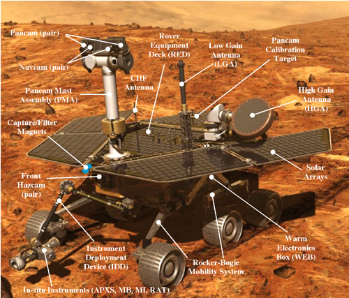
Mars Exploration Rover parts
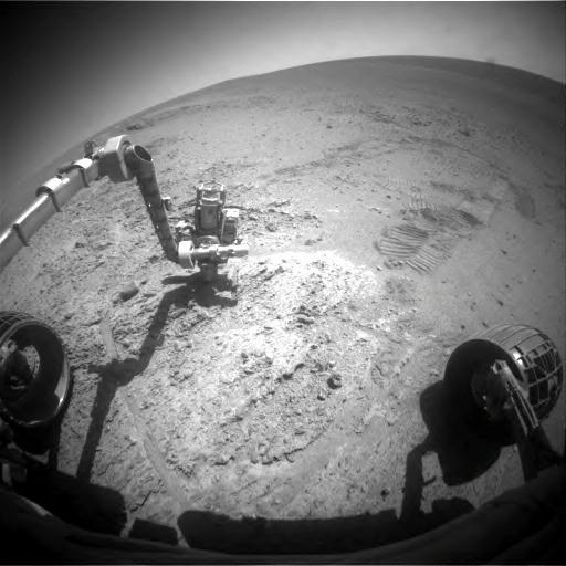
This labeled, simulated image of a rover on Mars shows the structure of the MER model. Designed as robot field geologists, each rover sports a body that protects "vital organs;" a brain or computer to process information; temperature controls or internal heaters, a layer of insulation, and more; a neck, head, and neck or mast for the cameras that give the rovers a human's 20/20 view; eyes and other "senses" in the form of cameras and instruments inform the rovers information about their environments; an arm to extend their reach; and wheels and "legs" for mobility; energy sources in batteries and solar panels; and a sophisticated communications system for "speaking" and "listening."Turned out, the IDD stall was a case of the rover doing exactly what it should have done. "Our standard procedure in setting up for taking Microscopic Imager (MI) pictures is to do a Mössbauer 'touch' to find the surface, and then the rover flips the IDD around and takes the MI pictures based on where the Mössbauer told us the surface was," explained Nelson by way of background.
Apparently an edge of the Mössbauer caught one of the edges of the "little valley" where the rover was trying to make contact with the ground or execute the "touch." Consequently, it never reached the intended contact point, the IDD stalled, and all motion stopped, Nelson explained. "It left us with a curious circumstance: motion stopped, but the contact plate never tripped. So, we knew that we didn't hit the surface, but we hit something," he said. "We finally imaged enough to figure that scenario out."
On Sol 2914 (April 4, 2012), Opportunity began the wheel stabilization. The rover moved her left front wheel, then wiggled it, and then repeated both movements to stabilize the wheel, and, ostensibly, the rover. "The wheel wiggle was intended to kick out any little rock that might be under there that might have caused any instability," said Nelson, "and everything went well."
With the IDD in its now regular modified stow position, Opportunity turned on her MI and took a picture of the left-front wheel. Although the image is out of focus, which is expected given the MI is a microscopic camera, the picture does show "good contact between the left-front wheel and the terrain," said Nelson.
NASA/JPL-Caltech/Cornell/ASU
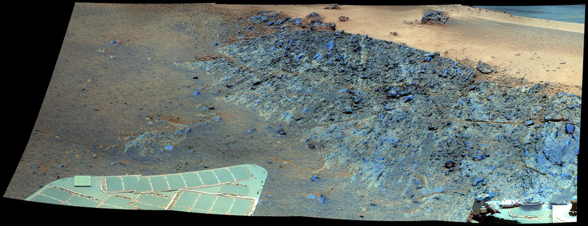
Parking at Greeley Haven
This image, produced in false color to emphasize differences in composition, clearly reveals that the rocks of Greeley Haven stand out in blue-gray tints. In the background at right lies a tan patch of sand. While Opportunity has been parked here for several months, it has been investigating interesting targets on this outcrop using the instruments on its instrument deployment device (IDD) or robotic arm.Opportunity used its other cameras, the Navcams and Hazcam, as well as the Pancam, to take additional diagnostic imaging to further confirm this. "We wanted Navcam images because we can run ground-based Visodom, the motion tracking software package that we have onboard the rovers, and which we can also run it on the ground systems, provided we have the before and after images to work with," Nelson said. "And since the rover had completed the Greeley Pan over time, prior to this 'wheel drop,' we retook those images at the same time of day so we could compare them too."
The team looked for changes in the horizon, as well as the wheel. "One of the concerns was: is this a motion of the wheel or was this a motion of the entire rover?" noted Nelson.
It appears – "almost exclusively" – to have been motion of the wheel, Nelson informed. "Inevitably any motion of the wheel should be reflected in the rover at large. However, in this case, the rover body motion was so slight it's below our ability to measure. It's in the noise," he said. "We can say that the left front wheel moved downhill (toward the right front wheel) by less than 1 centimeter. We can't see the middle wheels, but the right front wheel, and the two rear wheels did not move."
Confident that Opportunity is stable, the investigation of the wheel drop came to an end. "All of the imaging showed that the rover since then has been stable, with no detected motion after the wheel moves and wiggles," said Nelson.
So what happened? What caused the wheel drop?
"Most likely there was some tension in the suspension," said Nelson. "It happens. Or possibly a weakness in the bedrock that eventually let the wheel slip as the IDD was repeatedly moved."
The big concern with this little downward movement of the rover's left front wheel is, perhaps, the obvious: if there is a little motion, could there be more?
What if Opportunity were to slip down her 15-degree perch/ Most likely, she would "merely slide down a maximum distance of less than 1/2 meter (about 18-20 inches)" or "about two wheel diameters," said Nelson. The engineers have no real fear that the rover would overturn here. "The slope is only around 15 degrees and it takes more than 45 degrees to tip, and the suspension is pretty robust," he reminded.
Such a slip would affect the rover's positioning for images and placement of the IDD though – and this team is not interested in losing so much as a minute now that winter is giving way to spring.
NASA/JPL-Caltech/UA
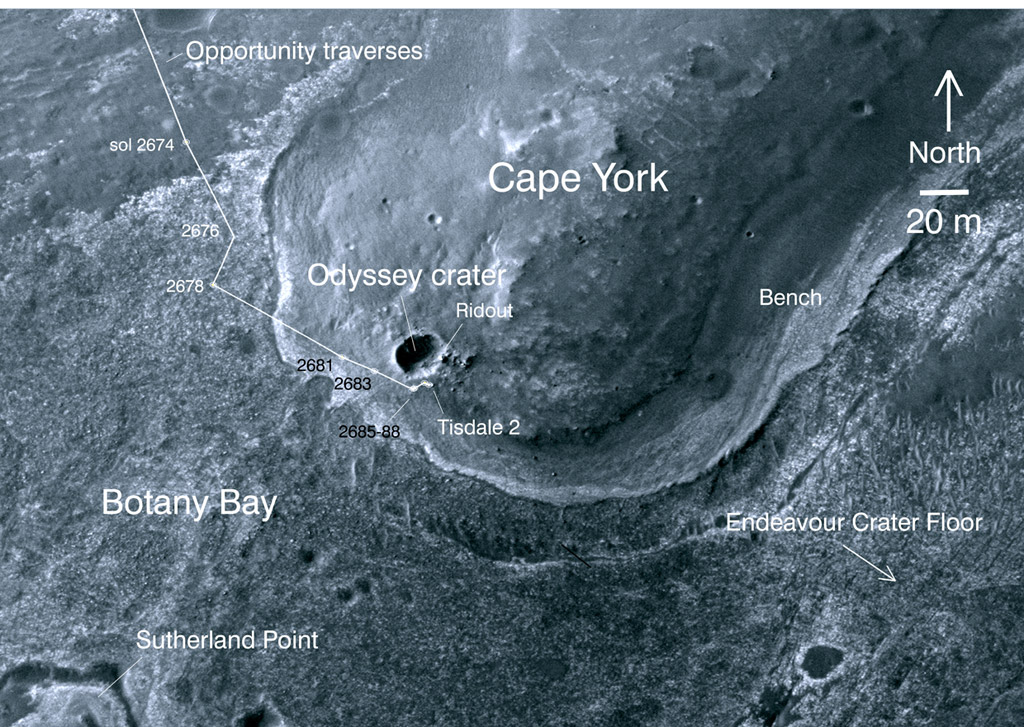
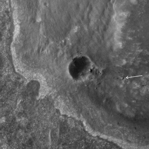
Opportunity at Endeavour, from above
This is part of a larger HiRISE image, taken from the Mars Reconnaissance Orbiter on September 10, 2011. It shows Opportunity sitting on some light-toned outcrops on the rim of Endeavour Crater, near a smaller crater dubbed Odyssey. It's easy to spot the smaller crater in the center of the photo, near the southern tip of Cape York. There's a rectangular object, right about at 3 o'clock, on the eastern rim of Odyssey. That is a large block of rock named Ridout. Opportunity is a bit farther to the east. See arrow in this zoomed-in view.On Sol 2915 (April 5, 2012), Opportunity turned her APXS to the sky and, measured the amount of argon in the atmosphere for a mission long, atmospheric research study, and then in the sols that followed resumed in situ or contact science on Amboy, with the MI and the APXS, both on her IDD.
Opportunity's attention was immediately directed to completing the oversized MI mosaic of the rover's foreground, a project the team began at the beginning of the winter. "The rover has been taking dozens of pictures of the bedrock on which it is parked for this massive MI mosaic, accompanied with APXS measurements on targets we call Amboy 1 through 9," summed up Callas.
The final MI mosaic will be a panel several feet long, comprised of at least 15 or 16 sections in which the sequentially numbered Amboy targets are located and a microscopic view of the rover's winter foreground is presented.
NASA/JPL-Caltech/ S. Atkinson
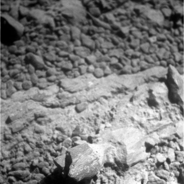
Beneath rover wheels
A world of rocks and ancient Martian history lies in and on the bedrock beneath Opportunity's wheels. The rover has been taking pictures of this world with its Microscopic Imager and creating a database, which scientists will be tapping for years to come.Meanwhile, Opportunity managed to continue the radio science research without interruption, averaging at least two Doppler tracking passes a week throughout April. The rover turned on her high gain antenna and pointed it toward Earth, linking with the DSN on Sol 2912 (April 2, 2012) and on Sol 2916 (April 6 2012); and then completed another pair of tracking passes during the second week of April, on Sol 2918 and Sol 2922 (April 9 and April 13, 2012).
In between, on Sols 2919 and 2920 (April 10 and April 11, 2012), Opportunity got back to the close-up examination of Amboy, the bedrock on which it's parked at Greeley Haven. After taking another suite of MI pictures of Amboy surface targets, each followed with a placement of the APXS for an overnight integration, the schedule became routine. "We've been doing an MI and then two sols of APXS integration, and then well do another MI on a new target and two sols of integration on that new target," said Nelson.
A little more dust from Opportunity's solar panels was whisked away as yet another dust guster blew in on Sol 2920 (April 11, 2012). The rover's energy level subsequently rose to hover between 336 and 342 watt-hours during the mid-month timeframe. The skies still remained hazy with Tau fluctuating between 0.504 to 0.526. The rover's solar array dust factor continued slowly to creep up and thus improve as April wore on, bouncing between 0.525 and 0.535.
Opportunity managed to squeeze in three radio Doppler tracking passes during the third week of April on Sols 2924, 2925, and 2927 (April 15,16, 18, 2012). The rest of the rover's time was devoted primarily to finishing the big MI mosaic. To that end, the rover took more pictures, specifically of the target labeled Amboy7-R13, on Sols 2924 and 2926 (April 15 and 17, 2012), and followed each photo session with an APXS integration.
On Sol 2928 (April 19, 2012), Opportunity took some time to snap Pancam pictures of the dunes, and then put her robotic nose back to the grindstone, taking more foreground MI pictures, again following each with an APXS analysis. That same sol, another dust guster cleared a little more of the rusty red powder coating Opportunity's solar panels, resulting in another 5 to 6 watt-hour increase to the rover's energy. It certainly wasn't a big jump in power, but little by little Opportunity was beginning to shake off her fifth Martian winter and get her game on for spring.
The following sol, 2929 (April 20, 2012), the rover retook one image of Amboy7-R13 because it was "a little out of focus," informed Nelson. Then, Opportunity moved the her MI just a bit, to Amboy8-R14, took some more pictures, checked out the target with the APXS, and then repeated the drill the next sol.
This past week, Opportunity closed out April doing more of the same, pointing her HGA toward Earth on Sols 2931 and 2933 (April 22 and 24, 2012) for the radio Doppler tracking passes; working on finishing the giant MI mosaic of Amboy, the foreground section of bedrock within the rover's reach, following each series of pictures on Amboy9-R15 on Sol 2931 and 2932 (April 22 and 23, 2012) with APXS measurements of the imaged area.
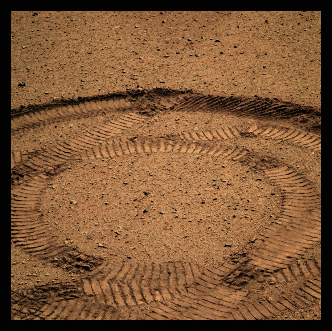
In addition, Opportunity used her Pancam on Sol 2932 to take pictures for the "change detection" experiment. Change detection is the catchphrase MER team members are using for the study of a patch of soil right in front of the rover's right front wheel, which is marked by the vehicle's track pattern, among other little Martian features. The scientists are interested in visually capturing how the wind is changing the surface, so at every opportune moment, the rover turns on her Pancam and takes pictures of that spot.
NASA/JPL/Cornell/ASU
Having fun with science
This image is one of many Opportunity has been taking of this area during the winter months. Scientists have been commanding the rover to continue to take images in order to see what kinds of changes are wrought by the Martian winds, and the rover's tracks present the perfect opportunity to see any ground cover alternations.The plan was for Opportunity to end April doing more Doppler tracking passes, and more work on the Amboy mosaic, and follow-on APXS integrations of the imaged areas for compositional studies. The sequences for Sols 2933 and 2934 (April 24 and 25, 2012) did not get onboard the rover because of "a couple of different problems" at the DSN station, so the rover spent those Martian days in "run-out," said Nelson. "Which means we didn't do much of anything."
The same commands were re-sent and on Sols 2935 and 2936 (April 26 and 27, 2012), and Opportunity conducted one of the last Doppler tracking passes she'll do for a good long while, and worked to finish the MI pictures and APXS analysis of the targets on Amboy. It is possible the rover will conduct a few more radio Doppler passes in May, but, "it will be a few, if any," said Arvidson. "We want to take the time and energy used for the direct-to-Earth transmissions and put it into APXS time," he said.
With the radio science work effectively completed, the MER team has tentative plans to have the rover "bump," or turn and move a short distance in early May to finish the work at Greeley Haven. "Because of Opportunity's broken shoulder joint, we're restricted to the vertical plane just underneath the rover, and we're beginning to run out of interesting places for IDD work," said Arvidson.
"Driving on this outcrop is tough because it's so rough, but we can do a bump," he continued. "The intent is to rotate the vehicle, so we get a new work plane, and that probably will happen within a couple of weeks."
If Opportunity does bump, she would then spend a few sols looking at new targets with her MI and APXS until she is able to drive away, Arvidson added. "That's the overall approach right now." In the meantime, the rover is "collecting data," he said, "and the analysis is kind of ongoing."
The Greeley Panorama is for all intents and purposes done, but Opportunity is still being instructed to re-take a few of the images. "Putting together the massive panorama is an undertaking," said Bell. "There's just a bunch of minutiae that has to be dealt with these large image products and it's slow work." There were some additional complexities with the Greeley Pan. "For example, the HGA was moving during one of the sequences, so it's in different places with different filters," he said, "and we went back and re-shot that and now that has to be inserted," he explained.
"We've been very busy," Bell continued. "However, we have this very nice data set we've been acquiring of the outcrop around us, so if we start by making a small move we'll be able to go some place close by that's very interesting."
In looking forward, the team is also looking back, if only for a moment, at this passing Martian winter. "The new thing this winter is the fact that Opportunity has been stationary and we were able to do the radio science campaign," reflected Callas. "That's a big deal. We haven't been able to do this in past winters with Spirit, because we never had the energy in the wintertime. This winter, with Opportunity, there was a convergence of not having enough energy to drive, but enough energy to do the radio science observations," said Callas.
The rover has her team to thank. "The engineering team did a lot to make the energy numbers work this winter, and I think that is a noteworthy accomplishment this winter," Callas said. "Not only were we able to do the radio science. We know we can always do it when the rover stops driving, but we showed that we can do it in the winter environment when power levels very low."
Previous thinking, back when the team was contemplating having Spirit do the radio science, projections were that the rover would need about 300 watt-hours of available energy to be able to do the radio science, because the rover's radio transmitter sucks a lot of power. "We were able to do it below 300 watt-hours and I give a lot of credit to the team to being invested in figuring out how to do that," acknowledged Callas.
Opportunity’s dogged determination and hard work through the winter – and the successful radio science data that promise to rewrite the planetary science textbooks and the glory of the Greeley Pan – are likely what will most be remembered about this fifth Martian winter.
NASA/JPL-Caltech/Cornell/ASU/S. Atkinson
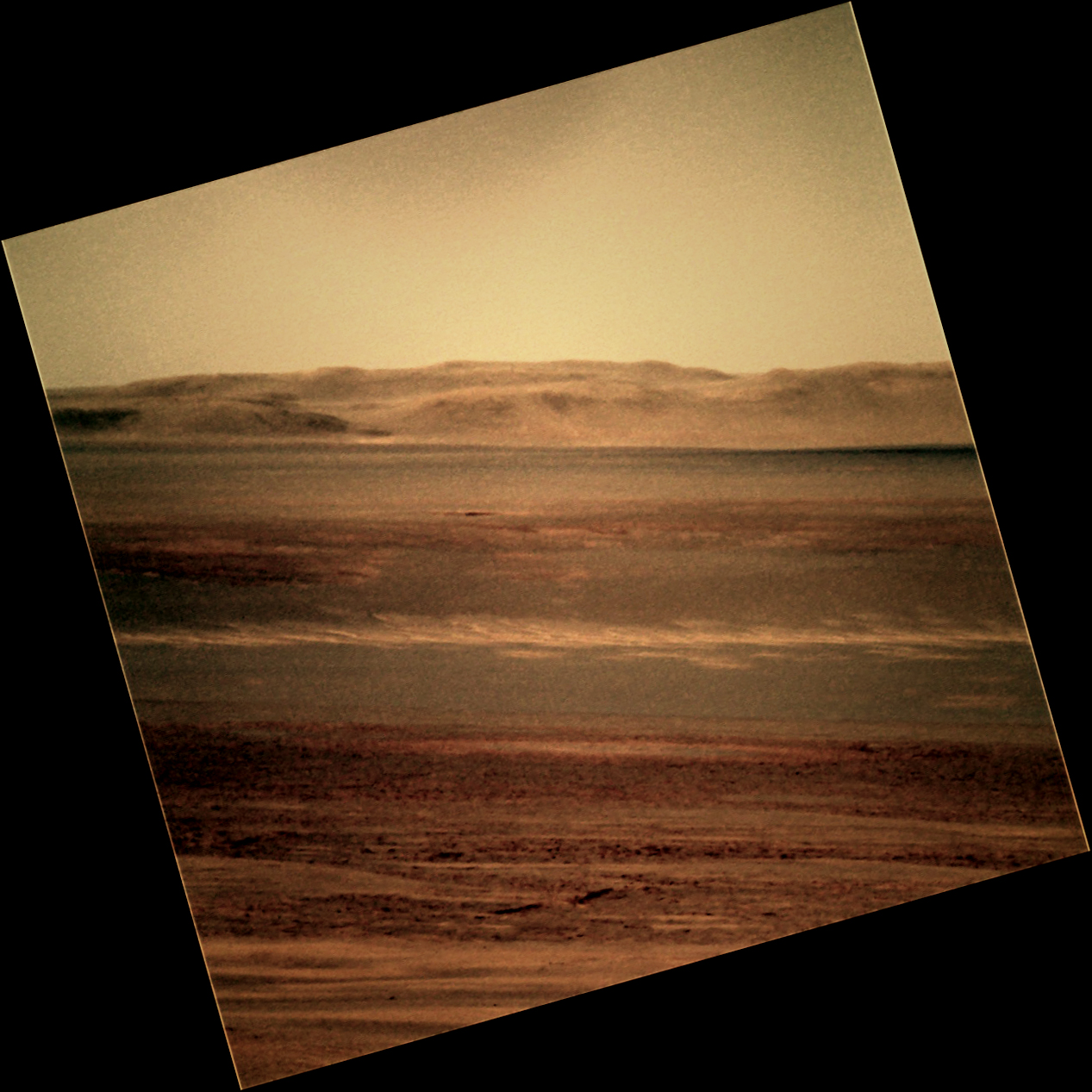
Gazing east
Opportunity took this picture of distant hills while gazing to the east with her Pancam, and Stuart Atkinson rendered it here in this color version. Those hills are more than 20 kilometers away, and so they won't be a destination for this rover, but the ridges and peaks are alluring just the same.The team's energy now is shifting to Opportunity's roving on. "We are really looking forward to driving away to new terrain," Arvidson said, echoing the sentiments of just about everyone.
At April's end, the rover was producing a fairly robust 366 watt-hours of power, and the engineers are JPL are re-assessing the Opportunity’s power condition and running new projections with regard to the earliest safe exit window for the rover.
"I think what will determine things now is how soon we finish the surface science campaign," said Callas. "We've been parked at Greeley Haven for the winter, doing the radio science, looking at Amboy and taking the images for this massive MI mosaic accompanied with APXS measurements, and shooting the Greeley Panorama. When the science team feels they have satisfactorily completed the winter campaign, then we will be in a position where we can start to move, energy permitting."
"We're eager to get going again and so as soon as the surface science is finished and energy allows, we will get roving," assured Callas. "Next month, I should be able to tell you when we're moving – if we haven't moved already."
Once Opportunity does pull out of Greeley Haven, the plan right now calls for the rover to drive back to the Bench. "We will go back to the Bench on a search for a wider [gypsum] vein that will completely fill the APXS field of view and that we would be able to RAT," said Arvidson. "We want to remove any surface coatings and get down to the pure material. That's an important priority."
The MER science team also wants to determine what exactly the Bench is made out of. The two leading hypotheses suggest that the Bench is with the oldest sedimentary rock on Mars with a lot of local Cape York material mixed into it; or more of the same old evaporating sandstones contaminated by surface soil.
"We were moving fast to get to the winter haven in December, and we stopped and made a rock measurement of the Bench on a target called Deadwood, but it's a dirty target, with a lot of sand on it," Arvidson pointed out. "So, in addition to a large vein, we want to get to the Bench bedrock, clean it off with the RAT, and really get at its true composition."
Following the Bench, there's the inward side of Cape York, where the Compact Reconnaissance Imaging Spectrometer for Mars (CRISM) instrument onboard the Mars Reconnaissance Orbiter detected a small bounty of phyllosilicates, a sure sign of past water that is more alkaline, more like water we Earthlings know, in the form of clay minerals known as smectites.
NASA/JPL-Caltech/JHUAPL
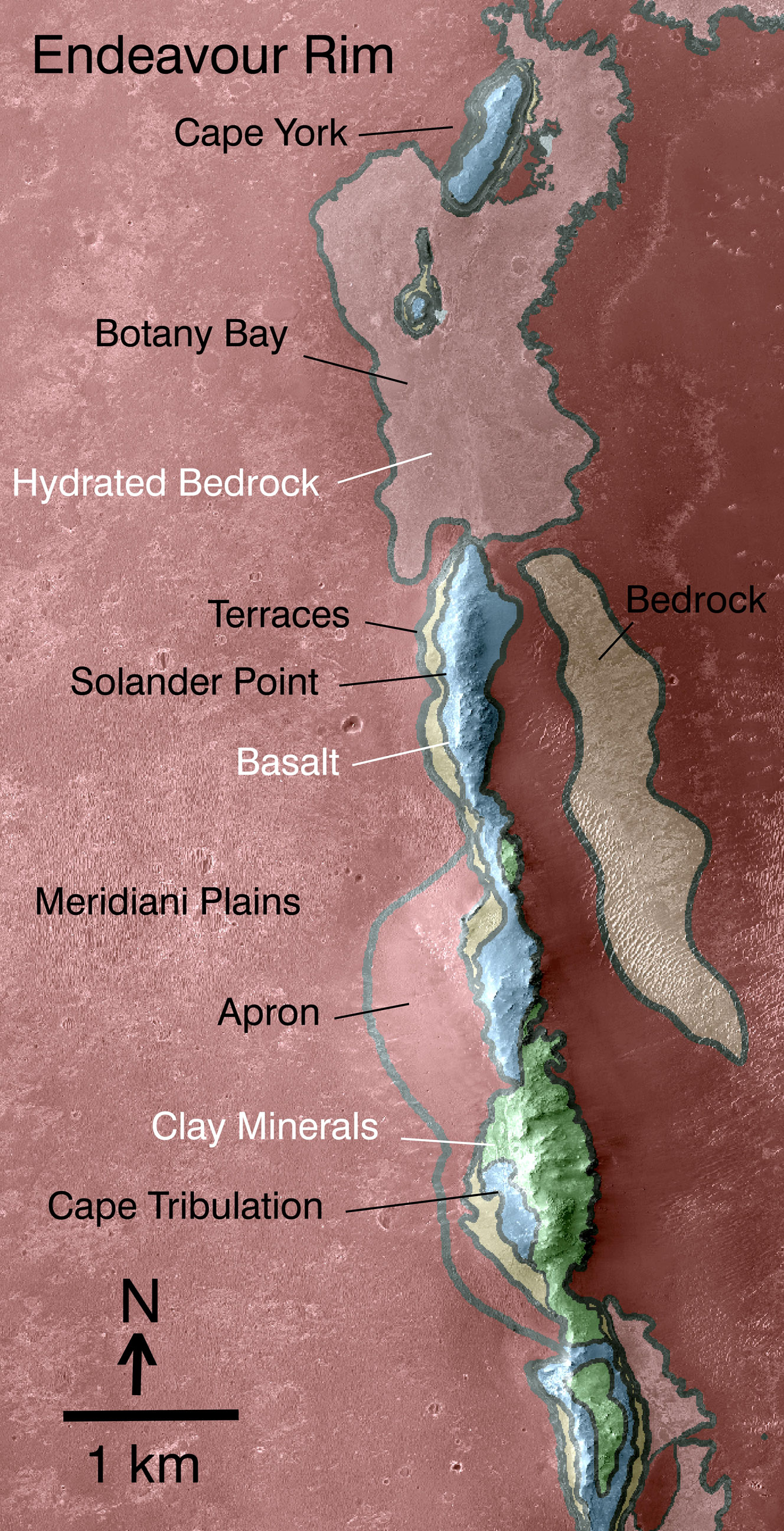
Geologic map, western rim
This map reveals the locations of where some of the geologic riches detected from orbital observations of Endeavour Crater. This crater is about 22 kilometers (14 miles) in diameter. As indicated by the scale bar of one kilometer (0.6 mile), this map covers only a small portion of the crater's western rim. A discontinuous ridge runs north-south, exposing basalt (coded blue) and clay minerals (coded green) believed to be from a time in Martian history before the deposition of sulfates on the portions of the Meridiani Plains region that Opportunity has seen during the rover's first seven years on Mars. This geological map is based on observations by the Compact Reconnaissance Imaging Spectrometer for Mars (CRISM) onboard MRO.As important as finding phyllosilicates is to the MER mission – it's an evidence-for-past-water discovery that would be by most accounts the single most significant scientific discovery on the entire mission – Opportunity didn't have time to search for the smectite before winter, "because the Sun wasn't high enough in the sky and we would have been tilted away from the Sun causing energy issues," remembered Arvidson.
"With the CRISM data, it's hard to tell what's there, but geologically that should be the place where the iron magnesium clay minerals – the smectite – should outcrop," added Arvidson, who is a co-investigator on the CRISM team. "There are no serious mobility limitations there, so we want to at least visit that place to do some reconnaissance imaging, as well as some close-up imaging with the MI, and analysis with the APXS."
And then?
Botany Bay, said Arvidson, the little valley between Cape York and Solander Point where CRISM sees evidence for widespread gypsum not as veins but as exposed rock, is the next likely destination. "That might be the rock that is in contact with the ancient crust underneath. It would make sense," noted Arvidson, who is leading a small team studying the aqueous geochemistry story of the area. “And then Solander Point and Cape Tribulation.”
"But," Arvidson added, “who knows where this vehicle is going to go?"
NASA/JPL-Caltech/Cornell/ASU /S. Atkinson
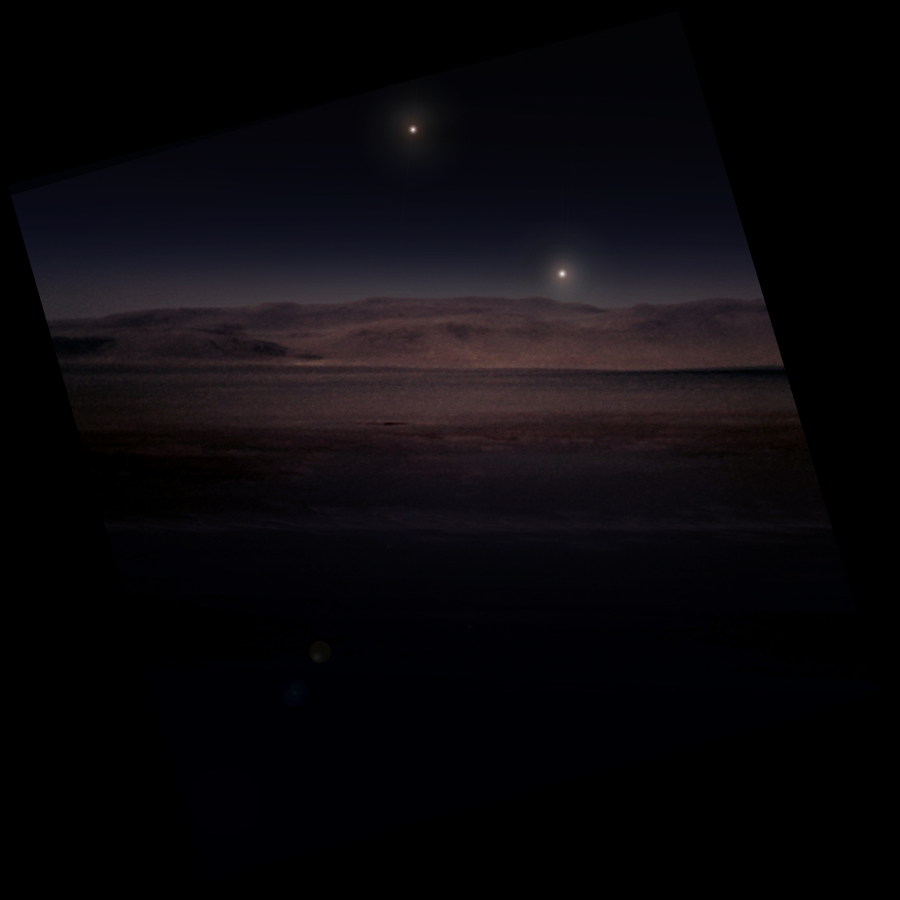
Imaginary starry, starry night
This is just an imaginary view of what Opportunity might be seeing as the Sun sets on Greeley Haven – and a beautiful image to close out this edition of the MER Update. It comes courtesy of Stuart Atkinson. For more of Atkinson's work, please visit his Road to Endeavour blog.Let’s Go Beyond The Horizon
Every success in space exploration is the result of the community of space enthusiasts, like you, who believe it is important. You can help usher in the next great era of space exploration with your gift today.
Donate Today