
 Explore Worlds
 Find Life
 Defend Earth


Emily Lakdawalla • Oct 25, 2013
Noachian, Hesperian, and Amazonian, oh my! --Mars' Geologic Time Scale
You may recall a few weeks ago a couple of blog entries I wrote after falling down a research rabbit hole: one on lunar basins, and one on the Geologic Time Scale on Earth and the Moon. Here comes the next step in my journey back out of that hole: the Martian Geologic Time Scale.
The fun thing about Mars is that there are a lot of events to date. Craters, volcanoes, tectonics, and water- and wind-related processes have all contributed roughly equally to its current appearance, and all have operated throughout Mars' history, with variation in their relative importance over time. Did I call this "fun?" I meant "confusing." But scientists enjoy being confused. Up to a point, anyway.
Scientists seeking answers to our questions about Mars' past have developed a pretty rich story for Mars' chronostratigraphic time scale. The summary I'm writing below comes from the chapter on planetary history written by Ken Tanaka and Bill Hartmann for The Geologic Time Scale 2012.
Just as on the Moon -- and presumably also Earth, though there's no record of it anymore -- there is an early history that was dominated by impacts, including some very large ones. On the Moon, this impact-dominated era was called the Nectarian Period; on Mars, it's called the Noachian Period. They were happening at overlapping times, but they didn't necessarily end at quite the same time.
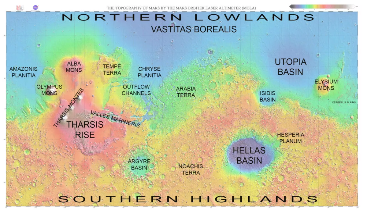
Very early in the Noachian, Mars' northern lowlands formed. Why there is this north-south dichotomy is still not known for sure. A huge impact like the one that created the Moon's south pole-Aitken basin is a very likely explanation, but it's not the only possibility. Regardless of how it happened, it's pretty much the oldest thing we know about Mars' geology: that the northern lowlands formed. Following that, just as on the Moon, large impact basins like Hellas and Argyre and Utopia establish a relative stratigraphy for this time period. But unlike on the Moon, there were a lot of other interesting things happening at the same time. Major volcanism was happening at the Tharsis rise by the middle of the Noachian period, and may have started earlier.
I'm throwing a lot of place names around here, so I made you a map:
By late in the Noachian period, material was being deposited in between older craters. It's hard to tell what made these intercrater plains because everything is so old. There's something that was happening on Mars at this time that was not happening on the Moon: valley networks were forming. I wrote about valley networks a couple of months ago. If you can see valley shapes carving cratered terrain, that means there was material -- sediment -- being carved out of the cratered terrain, washing through those valleys, and getting deposited somewhere. The Noachian intercrater plains are thus very likely water-related, deposits of sedimentary material. But this is admittedly a pretty circumstantial case. We know there was also volcanism happening at the time, and if there was an atmosphere there would have been wind, too. Some Noachian plains could be water-lain sediment, but they don't all have to be.
Recall that on the Moon, the end of the ancient impact-rich Nectarian period (and possibly the end of the Late Heavy Bombardment, if that was actually a thing that existed) is marked by the latest two large impacts -- Imbrium and Orientale. We can name the last three big impacts that happened on Mars: Hellas, Argyre, and Isidis, in that order. But Hellas, Argyre, and Isidis do not mark the stratigraphic boundary between the Noachian and the next period, the Hesperian.
Instead, the end of the Noachian and beginning of the Hesperian is marked by a subtle shift in Mars' geology, away from impacts and water-related erosion and deposition, toward volcanism. Hesperia Planum is an area in Mars' southern highlands where older craters have clearly been obliterated by younger, smooth deposits of volcanic origin. You can even see their smoothness in the low-resolution map of Mars I posted earlier.
Was there a sudden blast of increased volcanic activity to begin the Hesperian? Maybe yes, maybe no. All three major kinds of geology (impact cratering, sedimentary processes, volcanism) were happening in both Noachian and Hesperian time, but their relative importance shifted. Impact craters were happening more rarely, and valley network activity waned. Maybe volcanic activity increased, too -- but maybe volcanic activity just continued at the same pace it had before at the same time that cratering and valley network formation decreased. It's hard to say for sure.
The Hesperian period was originally named for the rocks that make up Hesperia Planum. But its beginning is actually no longer pinned to that; after getting better data from more orbiters, geologists have redefined the start of the Hesperian period using impact crater statistics. So the Hesperia Planum rocks formed in the Hesperian but they're no longer the single marker that defines the Hesperian. I'll come back to Martian crater statistics in a few paragraphs.
As the Hesperian period went on, Mars started producing outflow channels. These are very different beasts from the valley networks. Valley networks look like Earth river systems. Outflow channels are enormous scars from monster floods. They probably aren't related to rainfall, but instead to the sudden, catastrophic release of vast quantities of water from storage either in ice-dammed lakes or underground aquifers.
There is a good stratigraphic marker for Mars' third and most recent major period, the Amazonian. The vast northern lowlands -- the Vastitas Borealis -- mark the beginning of this period. This may be slightly confusing because I mentioned earlier that the northern lowlands have been low for pretty much all of Mars' recorded history. They were, and they likely periodically collected water from this or that channel throughout the Noachian and Hesperian. There may (or may not) have been an ocean inside it at one time or another; the jury is still out on that question. But after all of this happened, the whole floor of the northern lowlands was later filled by smooth deposits that covered up any previously extant cratering or ocean-basin record, and that event marks the beginning of the Amazonian. Curiously, in the Geologic Time Scale, Tanaka and Hartmann decline to suggest what the Vastitas Borealis deposits are, saying only that recent work has overturned a previous suggestion that it's stuff that came out of the Xanthe Terra outflow channels. They say the Vastitas Borealis deposits can be seen filling in the mouths of these channels, so they have to have formed later. What are the Vastitas Borealis? We landed on the stuff, with Phoenix, and we know it tends to be ice-rich, but we still don't know how they originally formed.
Although the Amazonian period has been quieter on Mars than the Hesperian or Noachian were, there has been geologic activity on Mars including both volcanism and outflow channels right through Mars' history. Some things are so recent that there are hardly any craters on some of the surfaces. That implies that Mars is capable of future geologic activity. But any such activity must be very, very rare, because there are still places on Mars that are little changed from the time long ago when planets were getting bombarded by impacts.
The modern chronostratigraphic time scale for Mars is pegged to the number of craters of different sizes that are present on the areas of different deposits. For example, ancient middle-Noachian surfaces will have more than 400 craters larger than 5 kilometers in diameter for every million square kilometers, while surfaces that date to the beginning of the Amazonian period will have only 25 to 67 of them on the same area. (Yes, the Geologic Time Scale is that specific.) On Mars you have to be extremely careful about processes that can modify the apparent age of a surface; but thanks to medium- and high-resolution imaging covering huge areas of the planet, the cratering record provides really excellent relative age dates that allow you to compare the relative timing of events that happened on different parts of the planet.
So here is a schematic diagram of the geologic history of Mars -- oldest on the bottom, youngest at the top. This is a relative time scale -- it tells you the order of things, but doesn't try to pin numerical ages to any of these events. This just lists a few of Mars' historical events -- the record is much more rich than this.
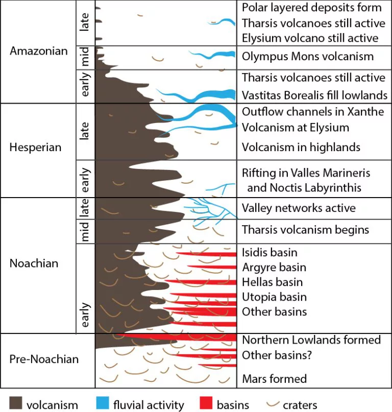
When we look at geologic history of the Moon, it's a punctuated one. The Moon's major events are an impact crater here, a massive pile of mare volcanism there. Many of its significant events happened nearly instantaneously, so they can be neatly ordered. Mars is different. It does have impact basins, which mark instantaneous events. But other stuff, particularly volcanism and fluvial activity, spans huge swaths of Martian history. When did volcanism happen at Mars' Tharsis rise? It happened over a very, very long period of time, beginning in the mid-Noachian and continuing right up until the present day. Any way you slice it, that's billions of years of volcanic activity.
Can we put absolute ages on any of this? Not very well. We can be reasonably confident that Mars and the Moon were getting battered by impact bombardment by the same basic population of impactors at the same time, since the impactors came from outside either system. So it's probably true that the Nectarian and Noachian periods overlap considerably. But since Mars' Noachian era wasn't ended by a last large impact but rather a change in geologic style, the boundaries aren't quite the same. Mars' Noachian period probably ended a couple hundred million years after the end of the Moon's Nectarian period. Give or take a couple hundred million years.
At the recent end of the time scale, one thing that's true on Mars that is not true of the Moon is that we can be confident that Mars geology has happened recently; we've seen change happen on Mars' surface with our own eyes (well, through robot avatars). We have even seen impact craters happen on Mars in before-and-after shots from orbiting cameras, so we're beginning to get actual data on how frequently small impacts happen. That will be invaluable for figuring out how long ago Mars' most recent geologic changes took place.

Tying Mars' crater-count ages to specific ages in years requires you to make informed assumptions about how often impacts occurred at different times in the past. We know that, long ago, impact rates used to be much higher than they are at present, but it's not as simple as a linear decline in the cratering rate. The cratering rate may not even have declined at the same speed for all size impactors. It's headache-inducing. Uncertainty about when impacts of different size were happening at different rates produces pretty huge ranges in estimates for the ages of some of Mars' historical events. The worst is the beginning of the Amazonian period, which might have happened anywhere from 3.5 to 2 billion years ago, depending on whom you talk to.
Which is why I am not even going to try to redraw my schematic time scale with numerical values for the years of events. No matter which years I pick, I will be wrong. I think it's a pointless exercise. I will stick with "Noachian," "Hesperian," and "Amazonian."
The reason I started reading about this stuff in the first place is because I needed to understand what was being written about how Mars' chemistry may have changed over time, and what that means for the scientific context of the rover missions. With the benefit of many years of data from four hard-working Mars orbiters outfitted with thermal- and near-infrared spectrometers, scientists have put together a story that says that ancient (Noachian) Mars had a chemical environment that was a lot like Earth's is today, with abundant water. The water altered rocks at a neutral pH to create clay minerals. Over time, that chemistry shifted to an acidic one that generated sulfate minerals. If this story is true, that shift happened somewhere around (though not necessarily on, and probably before) the Noachian-Hesperian boundary. Spirit landed on Hesperian-age rocks; Opportunity's rocks were slighly older, late Noachian. Both Mars Exploration Rovers found rocks that must have formed in an acid environment. Opportunity has now driven to more ancient rocks, bearing clay minerals. Curiosity is poised to explore rocks that cover the transition from clay-time to sulfate-time.
That entire preceding paragraph is an oversimplification, of course. And now it's time to delve more deeply into the story of Mars' chemical history. Reading a paper about that is what dropped me into the rabbit hole in the first place; it'll be the subject of my next post in this saga.
Let’s Go Beyond The Horizon
Every success in space exploration is the result of the community of space enthusiasts, like you, who believe it is important. You can help usher in the next great era of space exploration with your gift today.
Donate Today