Emily Lakdawalla • Apr 17, 2013
Tides of light and ice: Water and rock made from snowmelt on Mars
There's a new paper by Edwin Kite and four coauthors that is bound to become an important one for people who want to know what ancient Mars' climate looked like -- which, one assumes, includes pretty much anybody who's interested in Mars. It's titled "Seasonal melting and the formation of sedimentary rocks on Mars, with predictions for the Gale Crater mound" (PDF). In it, Kite proposes that much of the sedimentary rock on Mars could have formed during very rare, brief episodes of slight wetness. The paper's conclusion contains a line that I found poetical:
Seasonal melting on Mars is the product of tides of light and tides of ice....
The peaks of these tides infrequently intersect, and melting can occur when they do.
Here is the picture of Mars that comes out of Kite's snowmelt scenario. It's mostly dry, exceedingly dry, and cold. In the snowmelt era, it never rained. As it does today, wind blew dust and sand, building up thick piles in some places. Sometimes, it snowed.
Every couple of tens of thousands of years, in rare locations and under optimal conditions, there were a few years when snowpack near the equator melted for a few days under the high Sun of the equinox. The melting snow seeped into accumulated windblown sand and dust, briefly dissolving highly soluble minerals. The water didn't last long -- perhaps not even a day; and when it evaporated or froze, it had pinned some of that windblown sediment in place with a fine mineral cement.
So, it's possible that most of the layered sedimentary rocks that we see preserve a record only of those brief times when it was briefly wet, leaving much of Mars' past unrecorded. Kite calls this a "wet-pass filter of Mars' climate history."
There is an awful lot to this paper; it has taken me a couple of weeks to read and digest it. It's a paper about a computer model for certain aspects of Mars' climate, and of course models are inherently limited because they don't account for this, that, or the other thing that happens in real life. But any time we try to explain something that we observe in nature, our explanation is a model, a simplification of reality. Some models work better than others. This model seems pretty robust, as models go. Usefully, it makes predictions that Curiosity is able to test.
The snowmelt model
First, let's talk about what's in the model. Spatially, the model is a very simple one; the only parameter that describes position on Mars is latitude. For that reason it's called a one-dimensional model. Also included in the model are orbit parameters like the oval or circular shape of the orbit, the tilt of the rotational axis, and the position of the equinoxes on that elliptical orbit. These orbit parameters change with time, mostly cyclically. On Mars, they vary a lot more than they do on Earth, so their influence on climate is huge.
Then the model has three variables that act like knobs Kite could turn: the pressure of a carbon dioxide atmosphere; the amount of greenhouse warming contributed by gases other than carbon dioxide; and the amount of the surface that is covered by snow. These three numbers are not outputs of the model, they are inputs that Kite varied over a range to explore the behavior of the model. Here's the same list of variables, and how much they were allowed to vary over the full range of latitude:
- Orbital eccentricity: 0.0-0.16 (circular to elliptical; present-day value is 0.09, more elliptical than most. Even at its most extreme eccentricity, Mars' orbit looks like a circle; the effect of eccentricity is to make its distance from the Sun vary by a lot. At present, Mars' orbital distance ranges from about 210 to 250 million kilometers. At most extreme, Mars' orbit ranges from 190 to 260 million kilometers.)
- Orbital obliquity: 0-80 degrees (an astonishing range! Present-day value is a moderate, Earth-like 25.2 degrees of tilt; at most extreme, Mars' axis is nearly horizontal.)
- Solar longitude of perihelion: 0-360 degrees (At present, it is 251 degrees, which is close to the northern winter solstice. This means that Mars is closest to the Sun during northern winter, making northern seasons more temperate and southern seasons more extreme.)
- Atmospheric pressure: allowed to vary from 6-293 millibars. (Present-day value is 6 millibars.) Note: later in Kite's paper, when he uses his model to look at actual Mars topography, pressure is used as a proxy for elevation.
- Greenhouse forcing: 0-15 Kelvins. (Present-day value is a few Kelvins.)
- Fraction of planet surface area with warm-season snow: 0-50%. (Present-day value is quite small, around 1% -- the extent of the polar caps.)
Again, the orbital parameters are known to vary across the given ranges, while the atmospheric pressure, greenhouse forcing, and snow cover are parameters whose actual range is not known. Kite's "phase space" encompassed a reasonably broad range of possibilities.
A couple of words, before we proceed further, on the variations in Mars' orbit. Mars' present-day climate is much, much easier to model than Earth's because it is a much simpler system. Mars lacks the oceans and forests and organic processes like respiration and photosynthesis and decomposition that make Earth so maddeningly complicated. But once you start trying to model Mars' climate over timescales longer than a few hundred years, things get much more complicated.
In the context of this particular work, a weird thing happens when Mars' axis tilts over by more than 40 degrees. At present, with moderate tilt, ice is stable near the poles, making polar caps like we have on Earth. But when the tilt gets high, the sun blasts so much of each hemisphere around the clock for so much of the year, any polar ice is lost. Instead, when Mars has any permanent snow or ice, it's trapped near the equator, not the poles. I was surprised to see in one of Kite's figures that Mars' present-day combination of orbital parameters isn't representative of what might be considered "normal" for Mars. Mars spends more of its time with much higher tilt, in the regime where snow is happier near the equator than near the poles. Here's that figure:

Turning the crank
Kite's model works by calculating the daily temperature cycles over the course of a year for the full range of latitudes over all possible orbital (tilt, eccentricity, perihelion season) conditions. If the temperature gets high enough for melting (273.15 Kelvins minus any greenhouse forcing), the model pins the temperature there because melting buffers the temperature. In the model, the meltwater stays in place, which isn't particularly physically realistic. If nothing else, it would more likely percolate downward, and in fact that percolation is what turns sediment into rock. Kite acknowledges that the actual behavior of the meltwater is something that really needs to be studied further.
Kite repeated the process (of calculating daily temperature cycles over the course of a year for the full range of latitudes over all possible orbital conditions) for a variety of snow cover, pressure, and greenhouse forcing conditions. It's a pretty dizzying range of possibilities to explore.
How to summarize the model results when there are so many variables? Let's ask: when and where does melting happen? The model says that the rare times when conditions are right for melting snow happen almost exclusively during high-axial-tilt periods, when snow is most stable near the equator. They also happen almost exclusively when perihelion (closest approach to the Sun) happens at one of the equinoxes, so that the Sun is high overhead when Mars is closest to the Sun. This one took me a moment to wrap my head around: it's not summertime when melt happens, it's either the spring or autumn equinox. Melting only happens in a "melt season" lasting less than 50 sols. Another way of looking at that: if Mars had a 12-month calendar, the melt season would last less than one month.
The output of Kite's model is a gigantic multidimensional lookup table. The next step is to use that lookup table to predict where melting will occur on an actual Mars with actual Mars topography.
Real Mars
In Kite's model, the main effect of topography is on atmospheric pressure: if your elevation is high, your pressure is lower. That's it. Because latitude is the only spatial variable being explored (longitude and altitude are not described), there's no weather -- no wind, no dust storms. And remember, any meltwater doesn't go anywhere; it's assumed to stay in place.
Kite ran the model for real Mars topography across the full range of orbital parameters using 343 different sets of initial pressure, greenhouse forcing, and snow cover conditions. He found that the results grouped into four main kinds of climates:
- Perpetual desert. Like modern-day Mars, there is a thin, cold atmosphere and no melting on any horizontal surface anywhere, anytime.
- Relatively high atmospheric pressure and low to moderate snow cover gives you occasional snowmelt at high elevations.
- Lots of snow cover makes the model insensitive to topography; you get a broad band of snowmelt at low latitudes. More melt happens at the equator and it grades slowly away toward the poles.
- With moderate to low atmospheric pressure and either low snow cover or low greenhouse forcing or both, the result is a narrow equatorial band of snowmelt at low elevations.
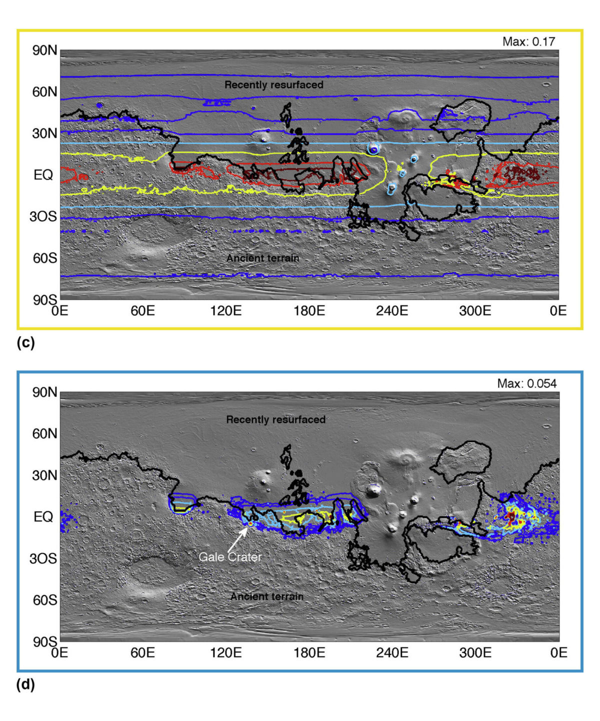
Here is a figure showing where snowmelt happens for the last two climates: broad, low-latitude snowmelt, when there's lots of snow cover; and focused, equatorial snowmelt at low elevations, when there's low pressure and low snow cover.
Can we see evidence for any of these in Martian geology? Yes, you can, and in fact the evidence is what led Kite to develop the model in the first place.
Where are the sedimentary rocks?
Mars has sedimentary rocks, but not everywhere. Kite took advantage of a data set describing where those rocks are, collected by Mike Malin and many others through the course of Mars Global Surveyor's productive photographic mission at Mars. He told me in an email that he took the catalogue and "regressed it against everything I could think of" but no matter what, it always seemed to be latitude that had the strongest control over the distribution of sedimentary rocks. He describes this more rigorously in the paper and explains that he finds the best match between sedimentary rock locations and his paleoclimate model is for the model runs that produce the narrow equatorial band of snowmelt.
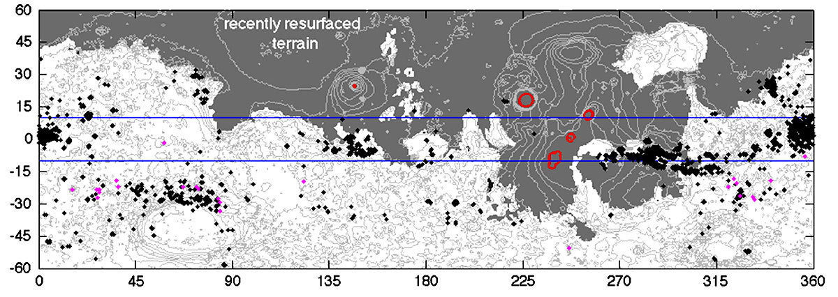
He also points out that while snowmelt at high elevations doesn't match the observed locations of sedimentary rocks, it correlates with the locations where you see "valley networks" on Mars. These are networks of branched channels that suggest widespread availability of liquid water (therefore either rain or widespread snowmelt). They're erosive features -- water took away sediment and left it somewhere else -- so there aren't associated sedimentary rocks in places where there are valley networks. Valley networks are old, older than most of the sedimentary rocks that we can see on Mars. So you could make an argument from Kite's model that the valley networks speak of a time on Mars when there was higher atmospheric pressure permitting snow at high elevations, but the observed low-elevation sedimentary rocks record a later time when conditions were more marginal, with lower atmospheric pressure and lower snow cover.
What does this all mean?
First of all, it implies that the conditions under which sedimentary rocks form on Mars are not like the ones that form rocks on Earth. Here on Earth, most sedimentary rocks were first laid down in seas or ocean basins, places where there was much more water than sediment, and the sediment settled to the bottom and started out its rock existence as a very broad, very flat, infinitely planar layer. On Kite's Mars, the situation was almost the exact opposite: instead of minor sediment settling out of lots of water, you have teeny amounts of water seeping down into thick windblown sediment. Under these conditions, the original topography of the windblown sediment deposits becomes the shape of the original rock "layer." Even if that layer had quite large surface topography, like, say, great big dunes.
And it only happens in special places. Remember that poetical line that I quoted? "Seasonal melting on Mars is the product of tides of light and tides of ice....The peaks of these tides infrequently intersect, and melting can occur when they do." Here's a figure that illustrates that. The "tide of light" is the dark red shaded area on the poles. The "tide of ice" is the dark blue thin equatorial band. Places where the red light and blue ice intersect are colored in green on this map.
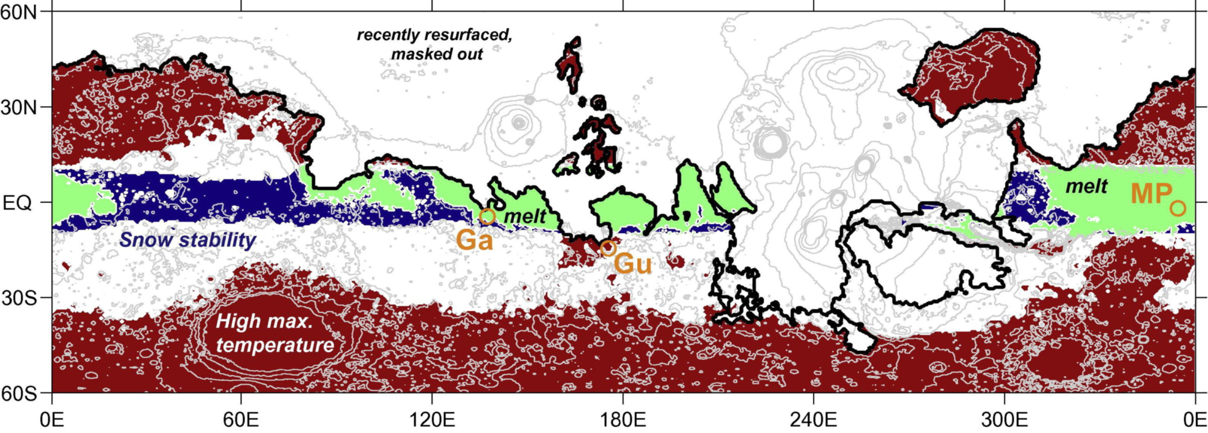
One interesting result of Kite's model is that almost any climate that produces any snowmelt anywhere on Mars produces some snowmelt inside the deep equatorial hole that is Gale crater. That's where Curiosity is now. "Gale would naturally be a place that would sustain sedimentary rock formation for a wide range of climate conditions," Kite writes. Gale's central mound is enormously tall -- five kilometers -- so different conditions prevail at its base than at its peak. It'd be wetter at the lower elevation near the base. "We predict a drying-upward sequence with most aqueous minerals deposited early (at low elevations) and few aqueous minerals deposited late (at high elevations). This is consistent with orbital spectroscopy and...mound topography."
But note that this is not a lake inside Gale, and most -- maybe even all -- of the sediments are not lakebed sediments but are instead windblown sand. "We hypothesize that the Gale Crater mound is an accumulation of atmospherically-transported sediments pinned in place and subsequently reworked by seasonal-meltwater-limited processes." They predict that the "Gale mound is a succession of tens to thousands of closed systems," because it's made of windblown sediment, pinned in place by meltwater cementation. The elemental chemistry should be the same everywhere, because the original sediment source is the homogeneous windblown dust that's all over Mars. But the elements can be mixed and matched into different minerals, depending on the amount of alteration.
Even though the environment being described here is not one that's particularly favorable to microbial life -- either its existence or, if it did exist, its preservation in the fossil record -- I find it geologically exciting. If each of Gale's layers represents a distinct, closed chemical system that formed in isolation from layers below it and without alteration by events that happened later, then Curiosity should be able to read those layers like the pages of a book to tell the story of how Mars' climate changed with time.
Of course, the first rocks Curiosity has explored don't fit this scenario. They are sedimentary rocks that do appear to have formed in an environment where water was not so sharply limited, and moreover, there has been enough water flowing around in those rocks since they formed to make one or even two generations of veins. But that doesn't necessarily falsify Kite's hypothesis. Curiosity is in the lowest-elevation spot in Gale's deep hole in the ground; if water ever pooled anywhere in Gale, it pooled where Curiosity is now. And these very low elevation rocks could've been buried much more deeply in the past; if they got deep enough, the geothermal gradient would've melted any ground ice and made things wet. Kite's model may well match the layered strata that are in the base of the mountain that Curiosity will hopefully eventually set off to explore. We'll find out if and when we get there.
As long and complex as this paper was, it doesn't include some factors that would've been very important for the formation of snowmelt and sedimentary rocks. For snowmelt, the main thing it doesn't include is a general circulation model -- basically, weather. I saw several talks at the recent Lunar and Planetary Science Conference that showed how weather, combined with Mars' topography, would cause ice to form in some locations and not in others; and that will modulate the patterns Kite described.
For sedimentary rocks, the model doesn't allow meltwater to actually move anywhere. Therefore meltwater in Kite's model doesn't do most of the things that liquid water does in real life: flow, erode rocks, pool, collect sediment, et cetera. Because I am a geologist, I found this omission jarring; as far as I'm concerned, the presence of water is only the beginning when it comes to making geology. But the purpose of Kite's paper is not to explain all of Mars; it's to explain under what conditions, and where, Mars' climate might have made liquid water available for geology to use to make sedimentary rocks. Now it's the geologists' turn to take Kite's model, and combine it with what orbiters and rovers have observed, to see if the model can help link clues together to form a coherent story for the history of Mars.
Let’s Go Beyond The Horizon
Every success in space exploration is the result of the community of space enthusiasts, like you, who believe it is important. You can help usher in the next great era of space exploration with your gift today.
Donate Today

 Explore Worlds
 Find Life
 Defend Earth