
 Explore Worlds
 Find Life
 Defend Earth


Emily Lakdawalla • Mar 20, 2013
LPSC 2013: Sedimentary stratigraphy with Curiosity and Opportunity
Oh my goodness, where do I begin?
It's always difficult to write up notes from conferences because they are so jam-packed. But I'm finding this year's Lunar and Planetary Science Conference to be unusually difficult to get a mental handle on. For reasons I can't explain, I feel like presentations this year are much harder to summarize than usual. I've got to try, though!
I spent all day Monday in Curiosity sessions, and yesterday afternoon in an Opportunity one. I mention these together because what the two rovers are doing right now is strikingly similar despite their different locations. Both are attempting to understand the local history of the activity of water in forming and altering layered sedimentary rocks on Mars. The tool that both missions are using is called "stratigraphy."

The science of stratigraphy goes back more than three centuries to Nicholas Steno. Steno developed three principles driving the interpretation of layered, or stratified, rocks: the principle of original horizontality (i.e. water-lain sediments were originally flat-lying); the principle of superposition (that younger rocks necessarily lie on top of older rocks); and the principle of lateral continuity (that sedimentary layers form as continuous sheets). I wrote a post about Steno's principles a couple of years ago; I'd recommend reading it as background to what the rovers are doing right now.
Both the Curiosity and Opportunity teams are trying to develop stratigraphic columns for their parts of Mars. Stratigraphic columns are a graphical representation of the sequence, thickness, color, grain size, and other aspects of the local bedrock, which can be read from bottom to top to tell the local geologic story. I wish I had time to illustrate this entry with Curiosity and Opportunity photos, but it's already taken me so long to write that I don't think I ought to delay any further.
The key talk for the Curiosity stratigraphy was given by Katie Stack. She explained how Curiosity had dropped 20 meters in elevation along its 500-meter traverse, and then described the variation in rock types observed along that traverse. For the first 400 meters, she said, outcrop was "patchy and intermittent"; exposures improved greatly after Curiosity got to the site named Bathurst. That has implications that I'll get to later.

Along the first part of the traverse (the patchy and intermittent outcrop part), Curiosity encountered lots of conglomerates and some sandstones. The conglomerates are, I think, one of the more important discoveries made by Curiosity to date. Becky Williams described the conglomerates exposed in the Goulburn, Link, and Hottah outcrops. She said they were polymict, meaning that the pebbles that they contain are diverse in both shape and color. At Link, she saw rounded pebbles embedded in a sandy sedimentary deposit. At Hottah, she saw "imbricated" stones. Imbricated means that flattish stones are stacked up at an angle to the presumed bed of the flowing water, something that happens when you have rapid water flow.
Williams quanitfied the roundness of the pebbles, showing them to be more than an order of magnitude rounder than anything seen at the Pathfinder landing site. She quantified the size of the pebbles, showing them to have a median grain size of 5 to 10 millimeters and a normally distributed range of grain sizes, similar to river pebbles seen in the Atacama desert. Taken together, all these data give stream depths for the Gale crater conglomerates of between 0.03 and 0.9 meters and flow rates of 0.2 to 0.75 meters per second, which are likely lower limits.
Curiosity left these conglomerates behind before getting to Jake Matijevic, which means, among other things, that they were never checked out with either MAHLI or APXS on the robotic arm. The outcrop was poor from that point until the rover got to Rocknest and entered a beautiful sequence of clearly layered, flat-lying, nicely superposed rocks. Bathurst and Cowles were fine-grained and laminated. Curisoity saw odd, "ropy" and "vuggy" rocks at Rocknest. Shaler is an outcrop of beautifully cross-bedded sands, then came Point Lake, a dark gray rock with abundant empty vugs. (Vugs are holes left by some mineral crystal that has since vanished.) Then came the shelf-forming rock layer of Gillespie, and under that, the Sheepbed unit, which is what Curiosity's wheels are sitting on right now.
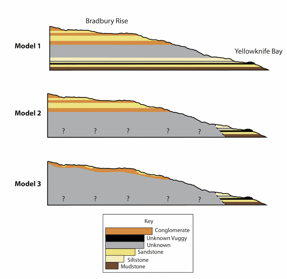
So how to interpret this stratigraphic column? One interpretation is straight Steno: you assume every rock you encounter is part of a laterally continuous rock, a "layer cake" stratigraphy. If you do that you can see a generally coarsening-upward trend, which might make sense if you're building up an alluvial fan over time. However, Stack said, orbital maps suggest that the relationship between Yellowknife Bay and Bradbury Rise isn't so simple.
The thing is, it's unlikely that the initial floor of Gale crater on which these sediments were being deposited was smooth and featureless. It was an eroded surface and had some topography. Then you'd get sediment being deposited in some places but not others, and not necessarily at the same times. A second interpretation of the rocks Curiosity has seen is that there were two distinct sedimentary stacks, one in Yellowknife Bay (finer grained, more obviously layered, lakebed or distal river sediments) and one on the "Bradbury Rise" (conglomerates and sands of the steeper alluvial fan). These two stacks could've been deposited in any relative order -- at the same time, or Yellowknife Bay before the Bradbury Rise, or vice versa. A third interpretation -- which is the one that seemed most in favor among the team -- is that the Yellowknife Bay stuff is nicely behaved layered stratified rocks but that the stuff on Bradbury Rise is a surface veneer on a preexisting hill.
Why does any of this matter? Because it gets to the question of when the habitable environment documented in the Sheepbed mudstones formed. Is it the toe end of the alluvial fan that comes down from the northern rim of Gale crater? If so, it's relatively late in Mars' geologic history, and it postdates the mound of rocks in the center of Gale. Is it, instead, entirely unrelated to that fan? If so, does the Sheepbed unit lie underneath the Gale mound? That would make it the oldest thing around. Did its sediments derive from the Gale mound? Then it's younger than the rocks in the mound, and of indeterminate relative age to the fan.
The only way that Curiosity might be able to answer these relative-age questions is to get moving. But the results of a casual survey I performed of friends on the Curiosity team is that the relative age of the Sheepbed unit might not be easy to figure out, even when (if?) Curiosity ever does get driving.
Over on the other side of Mars, there is (as Eldar Noe Dobrea said to introduce his talk on Tuesday afternoon) "a perfectly good rover sitting on ancient Noachian clays." He showed that there are smectites -- the same kind of clay minerals seen by Curiosity in the Sheepbed unit -- all over Endeavour crater. However, it developed in the rest of the Opportunity session that the evidence for Opportunity having found those smectites, while suggestive, isn't yet conclusive. But I'm getting ahead of myself.
Opportunity, unlike Curiosity, is traversing all over the place in order to get a good grip on the sequence of stratigraphic units at Cape York, on the rim of Endeavour crater. Larry Crumpler gave a very enthusiastic talk about this, about how Opportunity has essentially been walking along the contacts between sedimentary layers in order to map them out, like any good field geologist. The challenge is that Opportunity only has two functioning science instruments left: the APXS, which can count abundances of major elements heavier than sodium, and Pancam, whose multispectral color imaging can identify different rock units and give inconclusive hints as to what is going on mineralogically to make those rock units distinct.
Opportunity has spent the last many years rolling across the mostly aeolian sulfate sands of the Burns formation. The rim of Cape York is composed of older rocks that clearly underlie the Burns formation; they were raised into their current position by the Endeavour impact event. The Burns formation postdates the impact, so those sands "onlap" the rocks of Cape York.
Intriguingly, there is a thin layer of rock called the Grasberg formation that is basal to the Burns formation (meaning, it's a flat layer that underlies Burns everywhere and so formed before it) whose composition has "nothing in common" with Burns, Crumpler said. It's not a sand; it's a very fine-grained material (so fine that the Microscopic Imager can't see the grains), and it's harder than the soft Burns formation. It has "lots of alkalis and chlorine" and is "very similar to Clovis rocks" that Spirit saw at the Columbia Hills. Crumpler suggested maybe it was an airfall material (so, made of volcanic ash, maybe). Whatever it is, it's not a windblown sandstone.
Next down in the sequence is the suevite breccia of Shoemaker Ridge. That's an impact breccia (a rock made up of busted-up angular bits of rock broken in a major impact). This rock is probably but not necessarily associated with the formation of Endeavour crater. Below that is Whitewater Lake.
But what is Whitewater Lake? It's very fine-grained, and there's nothing about its texture (at least, nothing that Opportunity is capable of seeing) that tells us how it formed in the first place. Its fine-grainedness means that if it is an impact-derived sediment, it didn't have anything to do with the formation of Endeavour crater, because it's too close; sediment so close to the crater would be a breccia like Shoemaker Ridge. Therefore, it has to be older than Endeavour, which makes it very old indeed.
Steve Squyres and Barbara Cohen and Ray Arvidson all argued that Whitewater Lake is where the clay signal seen from orbit is coming from. But there was a puzzling lack of iron observed by APXS, meaning that their case, while strong, is still only circumstantial. So orbital data suggests that Opportunity is sitting on clay minerals, but Opportunity has not yet conclusively proven that. No matter what, Squyres said, Opportunity is sitting on "the most habitable environment that it's seen" throughout the mission. The Whitewater Lake rock is very old, and records an age before Endeavour crater.
Another thing that remains mysterious even after all of Opportunity's hiking around the outcrop is what the "newberries" are made of. Whitewater Lake is absolutely full of these round things that look a lot like the "blueberries" of the Burns formation, but they are absolutely not made of hematite. At least, not entirely. Rocks full of newberries are indistinguishable in composition from rocks mostly lacking them. I asked Matt Golombek how that can be, and he explained to me that these berries have a rind to them (the team likes to call them "crunchy on the outside and soft in the middle"), and that the rind likely has a distinct composition (enriched in iron) but that the interior does not. They will be trying a couple of tricks with the rock abrasion tool and APXS to try to figure out the story of the newberries.

There was one last enigmatic thing that Squyres mentioned during his talk. Whitewater Lake, and Shoemaker Ridge above it, are both shot through with calcium sulfate veins. But there's another spot with some intriguing boxwork veins, and preliminary APXS results show that it has a "very interesting composition," but Squyres was mum on what that was, only that it was "exciting."
Opportunity is wrapping up work on this spot. The rover will spend solar conjunction (which is most of April) examining Boxwork with the APXS, then will head south to the next bit of Endeavour crater rim, where the orbital signal of clay minerals is much stronger.
Squyres closed his talk by musing on the concretions found now in two totally distinct units at Meridiani and also in the Columbia hills and now at Gale crater, too. Concretions are really rare on Earth. You could land a hundred spacecraft on Earth and the odds you'd find concretions in two places would be really low. Yet they seem to be everywhere we find layered sediments on Mars. "Mars is trying to tell us something," Squyres said. "I don't know what it is, because it's speaking Martian."
I had a conversation later in the day with Matt Golombek about this. He said that what Mars is telling us with all these concretions and several generations of veins is that water has moved through its rocks, more than once. Since both concretions and veins mean that there's fluid that's dissolved some mineral from one place and redeposited it in a different place (or at least in a different way within the same rock), I asked Matt if that implied that these wet periods were brief -- you have a rock that's fairly unstable to being saturated, you saturate it, stuff goes into solution, you dry it out, stuff comes out of solution, and that's where you sit. Matt didn't really say yea or nay to my explanation but he did say it spoke to a lot of in-place alteration of rocks. He said that there's no conclusive proof yet that any of these clay minerals were ever originally exposed at the surface; they could've been formed as alteration products on deeply buried rocks. Which would disconnect the questions of the clay chemistry and the Martian climate.
It's all very complicated. I do think it's very exciting that we have two rovers exploring such similar-yet-different environments in two places on Mars -- the two missions will feed back into each other. And maybe Opportunity's continuing mobility will eventually inspire the Curiosity team to pick up anchor and start doing the kind of survey work that Opportunity is doing so capably, albeit with a much more limited instrument suite.
Let’s Go Beyond The Horizon
Every success in space exploration is the result of the community of space enthusiasts, like you, who believe it is important. You can help usher in the next great era of space exploration with your gift today.
Donate Today