
 Explore Worlds
 Find Life
 Defend Earth


Emily Lakdawalla • May 05, 2010
Morphology and mineralogy on Mars
The Planetary Geomorphology Working Group of the International Association of Geomorphologists (there's a mouthful for you) has an interesting feature on their website, a "planetary geomorphology image of the month." It's intended for an audience of its members, though, so the geological lingo can be a little bit beyond the reach of the public. I thought it'd be fun to take the most recent entry -- which demonstrates how you can combine the power of different types of data to tease out a rich story of the past history of one spot on Mars -- and "translate" it for the lay audience. The original was written by Bethany Ehlmann, a grad student at Brown University.
What high-resolution photos of the Martian landscape, combined with data from a longer-wavelength part of the electromagnetic spectrum, can tell us about Mars environments
The past decade of high-resolution orbital imaging of Mars has revealed gullies, dunes, fresh impact craters, polar layered deposits, and views of stacked, layered rocks. High-resolution imaging really began in 1997 with the Mars Orbiter Camera on Mars Global Surveyor, which achieved resolutions as high as 1.5 meters per pixel (and, on rare occasions, even higher). In 2003, Mars Global Surveyor was joined by the High Resolution Stereo Camera (HRSC) on Mars Express, which didn't have quite as high resolution (maxing out at 2.3 meters per pixel) but which had both color and stereo capability. And in 2007, Mars Reconnaissance Orbiter arrived, bearing the Context Imager (CTX) (6 meters per pixel, black-and-white) and the High-Resolution Imaging Science Experiment (HiRISE, up to 0.25 meters per pixel, with some color). These imagers have permitted detailed studies of how wind, ice, and water have shaped the development of Mars' landscapes.
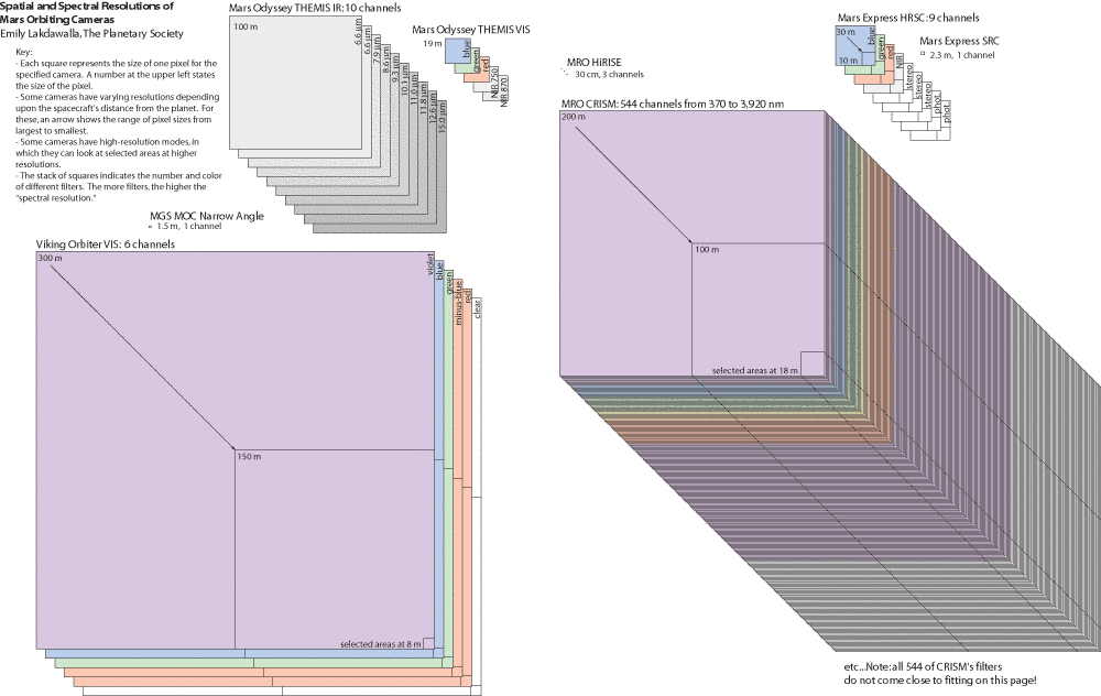
Equally important has been a different type of instrument: orbiting visible and near-infrared imaging spectrometers. As I've explained before on this blog, an imaging spectrometer typically does not have the sharp spatial resolution of the cameras I just mentioned. But what they lack in spatial resolution, they achieve in spectral resolution; they split the light that is reflected or emitted from Mars' minerals into dozens or even hundreds of tiny wavelength slices and measure the brightness of each spot on Mars at each wavelength. If you plot the intensity of the radiation on the Y axis and the wavelength on the X axis of a graph, you get what spectroscopists call a "spectrum" and what everybody else in the planetary science business refers to as a "squiggly line." They're squiggly lines to those of us who can't read them, but to spectroscopists they are rich with information about precisely what materials are present at every spot across Mars.
So, over the last five years, a new generation of imaging spectrometers including Mars Express' Observatoire pour la Minéralogie l'Eau les Glaces et l'Activité (OMEGA, which has a spatial resolution of 300meters per pixel) and Mars Reconnaissance Orbiter's Compact Reconnaissance Imaging Spectrometer for Mars (CRISM, 18 meters per pixel) has produced a vast store of squiggly lines that spectroscopists have read to discover numerous previously unseen minerals on Mars' surface. They include minerals like clays, sulfates, and carbonates, which rarely or never form directly from volcanic processes; they must have been made through alteration of primordial minerals, usually with the help of water in one form or another.
Now, with several years of work on the image data and the spectral data, scientists are beginning to explore what they can learn by merging the two data sets. The high-res images give you morphology, or the shape of the landscape; the spectral data let you identify minerals. Following are just a few ways that combining morphology and mineralogy has revealed more about ancient Mars.
Water on Mars: Change through time
Pretty much everyone agrees that Mars has seen liquid water flow across its surface at some point in its history. But there's still pretty poor understanding of how long such liquid flow may have lasted. Was it episodic -- just an occasional, catastrophic event, or did liquid water persist in rivers and seas as it does now on Earth? And was it local or global?
Let's look at one specific location. In and around the Nili Fossae of Mars, erosion and deposition have shaped the landscape. Channels have been incised into the bedrock in some locations; the material dug from those channels has been deposited inside craters, filling them up, and has also built fans and deltas much like those we see in Earth river systems. These events unfolded in the middle part of Mars' geologic history. It happened after a big asteroid or comet slammed into the planet to form the Isidis basin, which lies near Mars' equator and takes a good-sized bite out of the topographic boundary that divides its southern highlands from its northern lowlands; but it happened before lava flowed out onto the surface in the Syrtis Major region. Isidis is southeast of Nili Fossae; Syrtis Major is southwest.

Let's zoom in on a 40-kilometer-diameter crater in the region, which has been filled by a pile of sediment more than a kilometer thick.

CTX images of the center of the crater show that this thick pile of sediments has been eroded by a channel system that drained through a gap in the crater wall to the northwest. The CTX images also show that the layered materials within the crater have varying brightness, suggesting that the composition of the fill might change as you wander down the sequence of rock layers. Now overlay a CRISM image of the same region. The way that the CRISM instrument scans Mars' surface results in the distinctive bowtie shape of its spectral maps.

When you examine how the CRISM spectral data relates to the brightness of the layers, you can see that bright rocks are thin layers that contain kaolinite (Al2Si2O5(OH)4), a white, chalky mineral. Dark rocks are more massive and contain a clay mineral called smectite; further, you can tell (or, I should say, spectroscopists can read the squiggly lines to tell) that it is a particular "flavor" of smectite that contains iron and magnesium. Here's that chemical formula: (Fe, Mg)3(Si,Al)4O10(OH)2.
An aside on mineral formulae: have you ever seen a chemical formula that had a comma in it before? They're very common in writing formulas for minerals. When a mineral crystal is forming from a rock melt or a watery solution, it's just about as likely to incorporate an ion of iron as it is to pick up an ion of magnesium; the crystal structure doesn't care, because they both behave pretty much the same chemically and have similar-sized ions that fit into the same spots within crystal lattices. The amount of iron versus magnesium in any given mineral crystal depends mostly on the original abundances of those elements in the environment where the crystal formed. Similarly, the crystal may also pick up an ion of aluminum rather than silicon.
OK, so dark layers have smectite and bright layers have kaolinite. What does that tell us? If you compare these compositions to the rocks in the rest of the region, you find that smectite is actually pretty common. The massive, smectite-bearing rocks that fill this crater got their source material from nearby; it was transported there by the usual processes of erosion and deposition.
The kaolinite is another story. There's no regional deposit of kaolinite; it's unique to those thin, bright layers within the crater fill. So the mineral map from CRISM has told us something important: some event had to happen to change the existing smectite minerals in the crater fill rock into kaolinite, after the smectite had already filled the crater. How did this change happen? Here's why I bothered to include those chemical formulae. Remember that the smectite was already there, and it had a formula of (Fe, Mg)3(Si,Al)4O10(OH)2. When the smectite was altered, the new mineral that was formed was kaolinite, Al2Si2O5(OH)4. Can you examine those formulae and tell me what's different? Notice that the smectite has a bunch of elements -- particularly magnesium and iron -- that do not exist in the kaolinite.
This suggested to Bethany (who published a paper about it) that leaching was involved. A layer of smectite-bearing rock was exposed to the surface for a long time, during which it was occasionally gently wetted. Gently, because the rock wasn't eroded; the water just altered it in place. As water seeped into the rock, it liberated ions of magnesium and iron, taking them away and downward, leaving behind new minerals depleted in magnesium and iron. The process of deposition of smectite-bearing material, exposure and leaching had to be repeated for each bright layer of kaolinite to form.
Then things changed. The environment shifted into one that produced more intense erosional activity, and the northwestern rim of the crater was breached. With the water now seeking a much lower level, it had the erosive power to carve into the pile of sediments that had filled the crater. With only the photographs, it would have been challenging to identify these three separate episodes of different types of watery activity -- deposition, alteration, and canyon erosion. Mineralogy gave a necessary clue to what happened in the middle of the story.
You can see that combining photographs with mineralogical maps in this way could be of major help to the drivers on a long-distance Mars rover. Mineralogy is the goal for Opportunity's kilometers-long trek across Meridiani Planum: the rim of Endeavour crater contains the same kinds of iron/magnesium smectites that mineralogists found in Nili Fossae. Mineralogy is also a major driver for the landing site selection process for Mars Science Laboratory, the next great Mars rover set for launch in 2011.
What's next? Next is combining the beautifully detailed images with the mineralogical maps with high-resolution topographic information. HRSC, CTX, and HiRISE are all doing repeat imaging of the same spots on Mars (HRSC does it all at once, while CTX and HiRISE have to pass over the same spot twice to get the second view); from such repeat observations you can derive information on the 3-D structure of the landscape. Topography will help geologists understand what's up and what's down -- where stuff is being eroded from, and where it can be carried to. The work of putting all these different data sets together is just beginning!
There are lots more "images of the month" on the IAG website. Let me know if you have any requests for future translations!
Let’s Go Beyond The Horizon
Every success in space exploration is the result of the community of space enthusiasts, like you, who believe it is important. You can help usher in the next great era of space exploration with your gift today.
Donate Today