
 Explore Worlds
 Find Life
 Defend Earth


Emily Lakdawalla • Feb 23, 2010
Cassini at Enceladus: Baghdad's Glowing Canyon
The Cassini mission released a pile of images today from the super-close flyby of Enceladus that happened on November 21. I did a trio of posts on the raw images from that flyby (1, 2, 3), but now the images are enriched by professional processing plus added information from another of Cassini's instruments, CIRS. CIRS stands for the Composite Infrared Spectrometer; it looks at the icy worlds of the Saturn system in the long-wavelength part of the spectrum where the cold bodies glow thermally. Enceladus' south polar sulci -- otherwise known as the "tiger stripes" -- are some of the hottest things around, and CIRS has no trouble seeing them glowing away.
First, though, I have to post what'll probably be one of the most-reproduced photos from the Cassini mission. Just to be ornery, I'm posting it in the orientation in which I originally made my own version, with Enceladus' surface down and its plumes firing into the sky. (The official version is posted with north to the top, so the jets fire downward.) While I usually am a stickler for keeping north to the top, there's something about the flipped version that makes me feel like it's a frame from a feature film in which we are in a space ship, rocketing toward those jets.

Cassini's flyby took it to within 1,606 kilometers (more than triple Enceladus' diameter -- this was not among the closest flybys) of the surface, over a point located very close to the south pole. Thus Cassini was able to stare right down the throat of Baghdad Sulcus with its optical instruments. All the optical instruments -- that includes the cameras, CIRS, and the Ultraviolet Imaging Spectrometer (UVIS) -- share the same boresight, so when one is staring at something, the others can ride along. So they turned the spacecraft to align CIRS' slit-shaped viewfinder perpendicular to the trend of Baghdad Sulcus and panned the optical deck along the fissure, snapping camera images all the while.

The high-resolution mosaic image along Baghdad Sulcus is really spectacular. I added a scale bar to this image that I hope is correct.

Just after its near-south-polar flyby of Enceladus on November 21, 2009, Cassini snapped the four photos that were used to compose this mosaic image along Baghdad Sulcus, one of the four main "tiger stripes" that cross Enceladus' south pole.
At the end of the Baghdad Sulcus segment shown here, a distinct branching pattern of fractures can be seen forking away from the central rift. The main fissure and the branching rifts slice through a complex system of quasi-parallel, rope-like, rounded ridges each as large as a kilometer (half a mile) across and hundreds of meters (yards) in height. At scales of tens to hundreds of meters (tens to hundreds of yards), a fine network of small parallel cracks are pervasive, slicing through the valley walls of Baghdad as well as through the ropey ridges. Near the very top of the mosaic, the ropey terrain transitions to a distinctly different zone in which a complicated network of fractures subdivides a broad plain into complex polygonal patterns created by tectonics.
Image: NASA / JPL-Caltech / SSI / blame any scale bar errors on Emily LakdawallaAt the end of the Baghdad Sulcus segment shown here, a distinct branching pattern of fractures can be seen forking away from the central rift. The main fissure and the branching rifts slice through a complex system of quasi-parallel, rope-like, rounded ridges each as large as a kilometer (half a mile) across and hundreds of meters (yards) in height. At scales of tens to hundreds of meters (tens to hundreds of yards), a fine network of small parallel cracks are pervasive, slicing through the valley walls of Baghdad as well as through the ropey ridges. Near the very top of the mosaic, the ropey terrain transitions to a distinctly different zone in which a complicated network of fractures subdivides a broad plain into complex polygonal patterns created by tectonics.
What do the CIRS data look like? I found it easiest to study what was going on by making a blink gif:
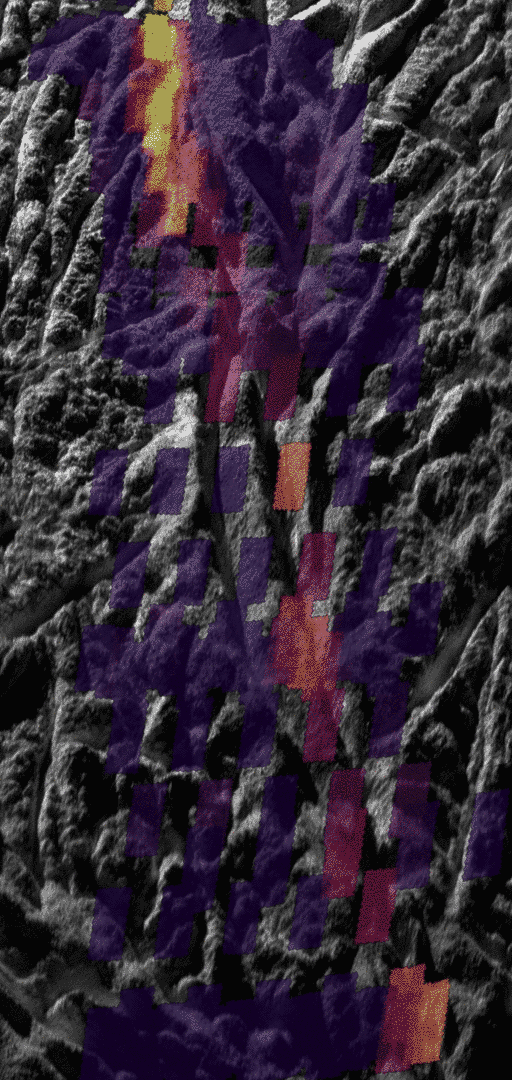
The temperature data gathered by the Cassini Composite Infrared Spectrometer (CIRS) shows how the surface along Baghdad Sulcus glows at an infrared wavelength of 10 to 16 microns. The thermal instrument has much lower resolution than the camera, so measurements appear as large colored rectangles atop the more detailed photo. The smallest features on the thermal map measure less than 1 kilometer across. The best previous map showed details no smaller than about 5 to 9 kilometers across.
The brightest colors in the map do not correspond directly to higher temperatures, but rather to a combination of higher temperatures and larger areas of warm surface material. The intensity of heat radiation increases as the color shades from violet to red to orange to yellow. No internal heat was detected in the darkest violet regions. Uncolored regions were not mapped by Cassini's composite infrared spectrometer instrument.
While the heat appears to emanate mostly from the main Baghdad tiger stripe, some of the fractures branching off or parallel to it also appear warmer and active to varying degrees, though this needs to be confirmed by further analysis. The total amount of infrared energy and the relative amounts given off at different wavelengths show that the highest temperatures along Baghdad Sulcus are limited to a region no more than tens of meters across. Most of the heat measured by the infrared spectrometer probably arises from the warm flanks of the active fractures, rather than their central fissures. The narrow central fissure is probably even warmer than the 180 Kelvin (minus 140 degrees Fahrenheit) detected -- possibly warm enough for liquid water in the fractures to be the source of the observed jets.
Image: NASA / JPL-Caltech / GSFC / SwRI / SSIThe brightest colors in the map do not correspond directly to higher temperatures, but rather to a combination of higher temperatures and larger areas of warm surface material. The intensity of heat radiation increases as the color shades from violet to red to orange to yellow. No internal heat was detected in the darkest violet regions. Uncolored regions were not mapped by Cassini's composite infrared spectrometer instrument.
While the heat appears to emanate mostly from the main Baghdad tiger stripe, some of the fractures branching off or parallel to it also appear warmer and active to varying degrees, though this needs to be confirmed by further analysis. The total amount of infrared energy and the relative amounts given off at different wavelengths show that the highest temperatures along Baghdad Sulcus are limited to a region no more than tens of meters across. Most of the heat measured by the infrared spectrometer probably arises from the warm flanks of the active fractures, rather than their central fissures. The narrow central fissure is probably even warmer than the 180 Kelvin (minus 140 degrees Fahrenheit) detected -- possibly warm enough for liquid water in the fractures to be the source of the observed jets.
The closer they look at Enceladus, the warmer they find those fractures to be. Early last year, I wrote an article for Sky & Telescope on Cassini's views of the icy moons, particularly Enceladus; at the time, the hottest temperature that John Spencer (who's on the CIRS team) could guarantee existed was 145 Kelvin. The difference between 180 Kelvin and 145 is huge -- think about it; it's like the difference between a snowy cold winter day and a blazing hot summer day. In fact, 180 Kelvin is well above the melting temperature of water mixed with abundant ammonia. Put another way, if you have ice and there is any ammonia in it, if you start heating it past 170 Kelvin, you'll start sweating off a mixture of ammonia with water. So temperatures of 180 Kelvin at Enceladus' surface make me much more ready to believe that there is some liquid (not sure how much) close to the surface than I have ever been before.
Have I mentioned how happy I am that this mission has just been extended another seven years?
Let’s Go Beyond The Horizon
Every success in space exploration is the result of the community of space enthusiasts, like you, who believe it is important. You can help usher in the next great era of space exploration with your gift today.
Donate Today